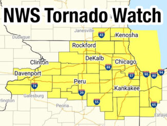
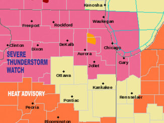
SEVERE THUNDERSTORM WATCH IN EFFECT UNTIL 4PM
SEVERE THUNDERSTORM WATCH OUTLINE UPDATE FOR WS 394 NWS STORM PREDICTION CENTER NORMAN OK 855 AM CDT SUN MAY 29 2011 SEVERE THUNDERSTORM WATCH 394 IS IN EFFECT UNTIL 400 PM CDT FOR THE FOLLOWING […]
Scattered thunderstorms are expected to increase, especially south of Chicago and east of I-55. Thunderstorms are most likely between noon and 3:00 p.m. There was a tornado warning in Livingston County near Pontiac and Dwight, […]
TODAY SUNRISE: 5:32 AM SUNSET: 8:24 PM Chicagoland weather radar shows severe thunderstorms devleoping at 2:15 PM. A large line of storms moving east is developing from Milwaukee to northwest Illinois and growing in intensity […]
URGENT – WEATHER MESSAGE NATIONAL WEATHER SERVICE CHICAGO IL 404 AM CDT THU JUL 28 2011 OGLE-LEE-DE KALB-KANE-DUPAGE-COOK-LA SALLE-KENDALL-GRUNDY-WILL- KANKAKEE-LIVINGSTON-IROQUOIS-FORD-LAKE IN-PORTER-NEWTON-JASPER- BENTON- INCLUDING THE CITIES OF…OREGON…DIXON…DEKALB…AURORA… WHEATON…CHICAGO…OTTAWA…OSWEGO…MORRIS…JOLIET… KANKAKEE…PONTIAC…WATSEKA…PAXTON…GARY…VALPARAISO… MOROCCO…RENSSELAER…FOWLER 404 AM CDT THU JUL 28 […]
According to the National Weather Service Chicago Office, we’re looking at a rather narrow window of opportunity to see surface based storms before the storm-diminishing cap regenerates early-mid evening. Surface based convection would mean a […]
A quick thunderstorm brought impressive clouds, but not much lightning and only a short burst of heavy rain in the northwest suburbs of Chicagoland. ComEd reported 68 Active Outages with 2,384 customers affected in Chicagoland […]
An outbreak of severe thunderstorms in the Southern U.S. is expected to continue well into the overnight hours. Severe thunderstorms are bringing strong tornadoes, very large hail, and severe wind gusts across parts of the […]
Severe Thunderstorm Warning BULLETIN – IMMEDIATE BROADCAST REQUESTED Severe Thunderstorm Warning National Weather Service Chicago/Romeoville 531 PM CDT Tue Sep 20 2022 The National Weather Service in Chicago has issued a * Severe Thunderstorm Warning […]
Weather Radar shows a large area of thunderstorms moving from northwest to southeast in northern Illinois heading toward the northwest suburbs, west suburbs, south suburbs and Chicago. UPDATE 10:34 PM — Storms have lost energy, […]
A Severe Thunderstorm Warning for the northwest suburbs was extended Monday night until Tuesday early morning at 12:15 a.m. A few tornadoes and scattered damaging gusts are possible through this evening centered on the southwest […]
WATCH COUNTY NOTIFICATION FOR WATCH 163 NATIONAL WEATHER SERVICE CHICAGO IL 405 PM CDT SAT APR 30 2022 THE NATIONAL WEATHER SERVICE HAS EXTENDED TORNADO WATCH 163 TO INCLUDE COOK COUNTY IN NORTHEAST ILLINOIS COOK […]
Less than 10 minutes left of a NWS Tornado Watch, and the second wave of storms headed northward toward Arlington Heights is dissipating. The NWS Office Chicago stated at 8:25 p.m. that the severe threat […]
A final arc of thunderstorms (a “Second Wave”), currently developing just northeast of the surface low over west central Illinois, will shift northeastward across northeastern IL and northwestern Indiana into early evening Monday, October 11, […]
A thin, but strong line of thunderstorms is moving from west to east, and is expected between 1:30 p.m. and 3:00 p.m. in the northwest suburbs of Chicago. Severe Thunderstorm Warnings have already been issued […]
The weather forecast for Monday and Tuesday includes a Tornado Watch Monday, and a Heat Advisory on Tuesday. A Tornado Watch is in effect from 2:40 PM CDT until 10:00 PM CDT on August 9, […]
©2024 Cardinal News | Apriori, Inc.