
According to the National Weather Service Chicago Office, we’re looking at a rather narrow window of opportunity to see surface based storms before the storm-diminishing cap regenerates early-mid evening. Surface based convection would mean a notably higher tornado threat with impressive 0-1 km shear.
Large hail and damaging winds will be possible with any storms near the low, but the likelihood will be maximized with surface-based convection. The other item of note is that the low-level jet may not arrive until after 6-7 PM, which may modulate (restrain) the tornado potential prior to its nocturnal intensification.
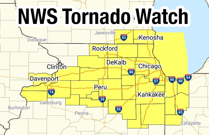
TORNADO WATCH OUTLINE UPDATE FOR WT 25
NWS STORM PREDICTION CENTER NORMAN OK
355 PM CST TUE FEB 27 2024
TORNADO WATCH 25 IS IN EFFECT UNTIL 1000 PM CST
ILLINOIS COUNTIES INCLUDED ARE …
BOONE, BUREAU, COOK
DE KALB, DUPAGE, FORD
GRUNDY, HENRY, IROQUOIS
KANE, KANKAKEE, KENDALL
LAKE, LA SALLE, LEE
LIVINGSTON, MARSHALL, MCHENRY
MERCER, OGLE, PUTNAM
ROCK ISLAND, STARK, WHITESIDE
WILL, WINNEBAGO
Weather Radar shows light precipitation in northwest and north central Illinois.
See also Arlingtoncardinal.com/clouds
A tornado watch has been issued for parts of Illinois, Indiana, Iowa and Wisconsin until 10 PM CST pic.twitter.com/WQEgbAPvnw
— NWS Chicago (@NWSChicago) February 27, 2024
O’HARE FORECAST …
Wind Advisory in effect from February 27, 09:00 PM CST until February 28, 06:00 AM CST
Tornado Watch in effect from February 27, 03:55 PM CST until February 27, 10:00 PM CST
Tuesday Afternoon: Mostly cloudy, with a high near 75. South wind 10 to 15 mph.
Tonight: Rain showers likely before 5am, then snow likely. Some thunder is also possible. Mostly cloudy, with a low around 21. Windy, with a south wind 10 to 20 mph becoming northwest 20 to 30 mph after midnight. Winds could gust as high as 45 mph. Chance of precipitation is 70%. New snow accumulation of less than one inch possible.
Wednesday: Snow likely, mainly before 8am. Cloudy through mid morning, then gradual clearing, with a high near 28. Blustery, with a northwest wind 20 to 25 mph, with gusts as high as 40 mph. Chance of precipitation is 60%. New snow accumulation of less than a half inch possible.
Wednesday Night: Clear, with a low around 17. Blustery, with a west northwest wind 10 to 20 mph, with gusts as high as 30 mph.
Thursday: Sunny, with a high near 44. Breezy, with a south southwest wind 5 to 10 mph increasing to 15 to 20 mph in the afternoon. Winds could gust as high as 25 mph.
Thursday Night: Mostly clear, with a low around 33. Breezy.
Friday: Mostly sunny, with a high near 49. Breezy.
Friday Night: Partly cloudy, with a low around 38. Breezy.
Saturday: Sunny, with a high near 61.
Saturday Night: Partly cloudy, with a low around 48.
Sunday: Mostly sunny, with a high near 68. Breezy.
Sunday Night: A chance of rain. Partly cloudy, with a low around 53. Breezy.
Monday: A chance of rain. Partly sunny, with a high near 66. Breezy.
Monday Night: A chance of rain. Mostly cloudy, with a low around 40.
Tuesday: A chance of rain. Mostly sunny, with a high near 52.
february.chicagoweatherstation.com
Chicago Weather Forecast for your MAC/PC/TABLET includes surrounding suburbs.
^^ MOBILE? USE VOICE MIC ^^
facebook …
Please ‘LIKE’ the ‘Arlington Cardinal Page. See all of The Cardinal Facebook fan pages at Arlingtoncardinal.com/about/facebook …
Help fund The Cardinal Arlingtoncardinal.com/sponsor
AREA FORECAST DISCUSSION …
National Weather Service
Chicago/Romeoville, IL
251 PM CST Tue Feb 27 2024
.KEY MESSAGES…
– Thunderstorms, some strong to severe, expected this evening
– Power-house cold front will rip across the area late this evening with a remarkable temperature dro
P- A quick hit of accumulating snow late tonight into tomorrow morning with a threat for slick morning travel
&&
.DISCUSSION… Issued at 251 PM CST Tue Feb 27 2024
Through This Evening:
We find an adolescent low pressure system that`s taking shape over far northern Missouri. This system is forming along the cold front of a parent low that`s currently traversing central Wisconsin. SPC mesoanalysis resolves strong upper divergence overlaid with some less impressive, albeit present, low level convergence over northern MO. The low has been deepening at a good pace dropping its central pressure from 992 to 990 between 11AM and 1PM. Nearby obs and RAP mesoanalysis data suggest that this low has begun to reel in moisture and instability from the east along a corridor that will shape into the storm`s warm front over the next several hours before moving into northern Illinois.
In our south, efficient low level moisture advection has been evident on satellite for some time. Now we find low 60s dewpoints reaching as far north as the Kankakee River valley. RAP mesoanalysis places 2,000-2,500 J/kg of MUCAPE across areas south of I-80 and around 1,000 J/kg in far north central Illinois. A capping inversion rooted around 850 mb remains in place over most of our area being the strongest in south of the Kankakee River and east of I-55.
Guidance remains in pleasantly good agreement on this low tracking right through the heart of the CWA, specifically along and north of the I-80 corridor. Forcing will be maximized near the low pressure center and in the system`s narrow warm sector. A lot of guidance has been consistently convecting on the northern and northwestern periphery of the low pressure center which equates to areas northwest of I-55. Here we`ll find the cold front of the northern parent low catching up to the mesolow`s warm front and result in strong low level convergence. Here is where we will also see the best potential for surface- based convection with the weakest capping in place (in the vicinity of the I-80 and possibly I-88 corridors). It`s looking rather likely that we`ll go uncapped for a period late this afternoon and early this evening. We`re looking at a rather narrow window of opportunity to see surface based storms before the cap regenerates early-mid evening. Surface based convection would mean a notably higher tornado threat with impressive 0-1 km shear. Large hail and damaging winds will be possible with any storms near the low, but the likelihood will be maximized with surface-based convection. The other item of note is that the low-level jet may not arrive until after 6-7 PM, which may modulate the tornado potential prior to its nocturnal intensification.
Farther south of I-80 and into northwest Indiana, the capping inversion will be harder to break later today and could possibly inhibit CI altogether. However, model soundings have been hanging on to less and less CIN this evening than with previous runs. The HRRR has been trending toward a more aggressive solution in this area since later this morning. Another driver to consider will be a dryline-like feature that will develop in this area this evening. This could help surface based parcels to break through the cap and convect. The density discontinuity doesn`t look quite as impressive as previously forecast, but, again, we`ll be working with a weaker cap. With the much greater instability overhead, robust convection with strong, broad updrafts look very attainable with any surface based storms that do develop in these parts. Should the cap hold, elevated convection isn`t out of the question. However, the environment isn`t nearly as progged for elevated severe storms as areas farther north.
The severe potential looks to wrap up late this evening, though the potential for surface based storms should drop off by 8 or 9 PM at the latest when the low levels become too stable. A stout low level jet will approach our south late this evening which would almost certainly aid in severe convection south of I-80 if it wasn`t expected to arrive just a little too late.
Doom
Tonight and Wednesday…
A truly powerhouse cold front will blast through the region this evening, ushering the severe weather threat east of the area. Temperatures will fall at an exceptional rate tonight as winds flip northwesterly–air temperatures are already in the teens and single digits across the Dakotas and Minnesota, and this is the airmass headed our direction (with just a bit of modification along the way). We`re explicitly indicating temperature changes on the order of 45 to 60 degrees into tomorrow morning which is obviously pretty remarkable.
With the strong baroclinicity involved, am a bit concerned that winds will “pop” during the frontal passage as a zone of 6+ mb/3 hour pressure rises blasts across central Illinois. Wind gusts have been overperforming model guidance immediately upstream, and suspect that will continue given the notable pressure rise/fall couplet and density discontinuity associated with the front. Have elected to hoist a Wind Advisory to cover this potential late this evening/early overnight for much of the forecast area.
In addition to the winds, guidance continues to suggest that a narrow but potentially robust/sharp frontogenetic circulation will mature in the post-frontal airmass overnight tonight as the left exit region of a 150+ upper jet blasts across downstate Illinois and central Indiana. Unfortunately, the placement of this f-gen circulation remains hopelessly unclear, with some model output indicating this sets up across far northwest Illinois into SE Wisconsin, while other guidance is farther south. The multi-model consensus favors this somewhat farther south solution at this time. Regardless, if this f-gen band develops, there`s plenty of instability aloft (near-upright instability with theta-e lapse rates around or less than 0) to support a brief burst of heavier rates as the columns rapidly cools, allowing for a full changeover to snow. Main window for this occurring is about 3 to 8 am, with the best guess that we`ll see a coating to perhaps an inch across the central half of the CWA, although will note there`s a big degree of uncertainty in placement of any snow band tonight. On the high end, a 2 inch amount isn`t out of the question.
Finally, given such a robust temperature fall, there`s some concern for a flash freeze with any lingering wet pavement overnight, particularly across northwest Illinois where there will be less time between precipitation ending and sub- freezing temperatures arriving. Something we`ll also be keeping a close eye on.
Windy/blustery/cold conditions will occur on Wednesday, with morning wind chills either side of 0 degrees in most spots. Temperatures should claw their way towards the mid and upper 20s, but the strong winds will hold wind chills in the single digits and teens all day. Wind gusts could get close to advisory criteria (45+ mph) through the day, although current indications point to winds–on the whole–coming up just shy at this time.
Carlaw
