
An outbreak of severe thunderstorms in the Southern U.S. is expected to continue well into the overnight hours. Severe thunderstorms are bringing strong tornadoes, very large hail, and severe wind gusts across parts of the lower to mid Mississippi Valley, Mid-South and parts of the Southeast. A few long-track strong tornadoes remain possible.
FAA National Airspace
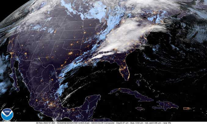
In the Southeast … A line of strong to severe thunderstorms will likely be ongoing at the start of the period later Wednesday morning November 30, 2022 from near the mouth of the Mississippi River northeastward into Georgia. This line is expected to continue moving quickly southeastward across southern Alabama, the Florida Panhandle, and central/southern Georgia through midday.
A sufficiently moist and unstable airmass should be in place ahead of the line across these areas, with weaker instability with northward extent into Georgia. Given the linear convective mode, scattered damaging winds should be the primary severe threat Wednesday morning. Low-level flow is forecast to gradually veer and weaken with time as a southerly low-level jet shifts northward and away from the surface warm sector. This should result in slowly weakening low-level shear through the morning. However, a tornado or two embedded within the line may occur before the low-level flow veers/weakens too much. Convection should diminish in coverage and intensity through the afternoon across southeast Georgia and north Florida as it encounters a less unstable airmass and becomes displaced from the stronger forcing aloft.
Mid-Atlantic/New England… A pronounced mid/upper-level trough initially over the Great Lakes and Ohio Valley will move east-northeastward over the Mid-Atlantic and New England by this evening. A strong cold front will develop eastward across the Mid-Atlantic and Northeast through the day, with rather meager low-level moisture return expected along/ahead of the front. Still, the gradually increasing moisture, favorable low-level convergence along the front, and strong large-scale ascent may support the development of a low-topped frontal band within the larger precipitation shield. Strong wind gusts could accompany any such convective band. But, with surface-based instability forecast to remain negligible, the potential for convectively enhanced gusts appears too limited to include severe wind probabilities at this time.
An upper-level trough will move across the Midwest and Northeast over the next couple of days. An upper low will open into a trough and amplify while it enters the Northwest.
A deep low pressure system currently moving through the Mississippi Valley will continue to focus showers and thunderstorms across the region and points eastward over the next couple of days. The most immediate threats will come from potential severe thunderstorms and excessive rainfall that are forecast for portions of the Lower Mississippi Valley, Southeast and central Gulf Coast tonight. A moderate risk of excessive rainfall leading to flash flooding is in effect over parts of southern Mississippi, southwestern Alabama and far western Florida embedded within a broader slight risk encompassing the Southern Appalachians, Lower Mississippi Valley and Southeast. Training thunderstorms may cause exceptionally heavy rain rates for the aforementioned areas. A moderate risk of severe thunderstorms is in effect over parts of northeastern Louisiana, extreme southeast Arkansas, central and northern Mississippi and northwest Alabama. Strong tornadoes, very large hail and severe wind gusts are forecast overnight. Regional outbreaks of severe thunderstorms and tornadoes are forecast for parts of the Lower Mississippi Valley tonight. Reduced visibility in the evening will add additional danger to those traveling within the affected areas tonight.
Elsewhere, another low pressure system will bring heavy low elevation rain and heavy mountain snow to the Pacific Northwest tonight through Wednesday before shifting its attention to southern Oregon and northern/central California on Thursday. Anywhere between 1-2 feet are likely for the Cascades on Wednesday with isolated higher amounts possible. Parts of northern Washington/Idaho and central/southern Idaho may receive between 4-8 inches through tomorrow. Snowfall will pickup over the southern Cascades, northern California and the Sierra on Thursday with 1-2 feet of snow possible for these areas. An additional 8-12 inches of snow are possible for parts of the Northern Rockies on Thursday. Winter Storm Watches Warnings and Winter Weather Advisories are in effect over much of the Pacific Northwest and western mountain ranges.
Some light to moderate snowfall is forecast to impact portions of the Upper Midwest/Great Lakes through tomorrow as moisture wraps around the low pressure system and interacts with a cold continental airmass flowing into the central third of the country. Winter Weather Advisories and Winter Storm Warnings are in effect from southern Minnesota to the western Upper Peninsula of Michigan. The departing cold front in the East will shift winds out of the northwest leading to the development of lake effect snow bands downwind of the Lower Great Lakes where 6-12 inches may fall on Thursday. Temperatures will be above average across the East Coast through Wednesday afternoon when the cold front will pass and drop temperatures. The Great Plains begin to warm up beneath upper high pressure on Thursday.
Kebede/NWS Weather Prediction Center College Park MD
+++++++++++++++++
CONUS = Continental United States
SOURCE: NOAA/NWS Weather Prediction Center
AIR PRESSURE MAP SOURCE: Windy.com (air pressure)
Get updates from The Cardinal ALL NEWS FEEDS on Facebook. Just ‘LIKE’ the ‘Arlington Cardinal Page (become a fan of our page). The updates cover all posts and sub-category posts from The Cardinal — Arlingtoncardinal.com. You can also limit feeds to specific categories. See all of The Cardinal Facebook fan pages at Arlingtoncardinal.com/about/facebook …
Help fund The Cardinal Arlingtoncardinal.com/sponsor
SOURCES:
Short Range Forecast Discussion NWS Weather Prediction Center College Park MD
Google Maps
The Maritimes — New Brunswick, Nova Scotia, and Prince Edward Island


