
Weather Radar shows a large area of thunderstorms moving from northwest to southeast in northern Illinois heading toward the northwest suburbs, west suburbs, south suburbs and Chicago.
UPDATE 10:34 PM — Storms have lost energy, but there is one more round due thorough the area after midnight, but the storm strength is uncertain at this time.
The first cell looks at 8:30 p.m. to be passing just south of Arlington Heights (or at least central and north Arlington Heights). Most of Arlington Heights is only getting rain and distant rumbling thunder from this cell. There is additional development heading our way behind the first cell, which looks more likely to affect Long Grove, Palatine, Rolling Meadows and all of Arlington Heights. The additional development at 8:50 p.m. included a cell over Rockford, and a cell near Dubuque, Iowa and southwest Wisconsin — both moving our way from northwest to southeast.
See also Arlingtoncardinal.com/clouds
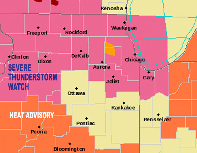
Thunderstorms continue to slowly spread southeast this evening. The highlighted area will see the greatest risk for scattered severe storms over the next two hours or so, with activity gradually shifting south with time. Damaging winds, flooding, & a tornado all remain possible. pic.twitter.com/ikTuVnWoN3
— NWS Chicago (@NWSChicago) July 6, 2022
Severe Thunderstorm Warning including Aurora IL, Naperville IL and Wheaton IL until 9:00 PM CDT pic.twitter.com/NYAUBH8Qq4
— NWS Chicago (@NWSChicago) July 6, 2022
Severe Thunderstorm Warning including Elgin IL, Crystal Lake IL and Carpentersville IL until 8:30 PM CDT pic.twitter.com/DC4K20blIP
— NWS Chicago (@NWSChicago) July 6, 2022
Severe Thunderstorm Warning including Belvidere IL, Woodstock IL and Huntley IL until 8:00 PM CDT pic.twitter.com/EA1jPnRSHD
— NWS Chicago (@NWSChicago) July 5, 2022
According to NWS Chicago, incipient thunderstorm development has been surprisingly sluggish to get going here this afternoon, as there is evidently some impact from dry air entrainment on diminutive updraft pulses. Thunderstorm development is being detected in the vicinity of a lake breeze/lake-enhanced cold front.
Of greater immediate concern, however, is the recent uptick in convective vigor just north of the Wisconsin state line where Geostationary Lightning Mapper (GLM) lightning trends have been solidly upwards over the last half hour.
Deep shear vector orientation is east-southeasterly, roughly parallel to the surface frontal boundary which stretches from near Prairie du Chien, WI to Southern Wisconsin Regional Airport to Schaumburg Regional Airport and to the southern end of the lake.
Expect continued gradual convective amalgamation as a result with activity oozing preferentially south and eastward over the next several hours. While low-level flow is unimpressive (0-1 km shear less than 20 kts), incredible 0-3 km MLCAPE and the presence of enhanced near-surface vorticity in the vicinity of the front suggests there is a tornado potential near any stronger updrafts.
Main threat however will be damaging wind gusts. Main severe threat area through about 8:00 p.m. to 9:00 p.m. is defined well by the current Severe Thunderstorm Watch, roughly along and north of I-88. Additionally, slow storm motions and overall convective orientation suggests an increasing flash flood threat as this activity pushes into northern Illinois.
For LIVE Tornado Warnings for our area and United States, see Arlingtoncardinal.com/tornadowarning or Twitter.com/NWStornado
O’HARE FORECAST …
Tonight: Showers and thunderstorms, mainly before midnight. Some storms could be severe, with large hail, damaging winds, and heavy rain. Low around 70. Northeast wind 5 to 10 mph. Chance of precipitation is 80%. New rainfall amounts between a quarter and half of an inch possible.
Wednesday: A 40 percent chance of showers and thunderstorms, mainly before 10am. Mostly cloudy, with a high near 81. North northeast wind 5 to 10 mph.
Wednesday Night: A 50 percent chance of showers and thunderstorms, mainly after 10pm. Mostly cloudy, with a low around 68. North northeast wind 5 to 10 mph.
Thursday: Showers likely and possibly a thunderstorm. Mostly cloudy, with a high near 82. East wind 5 to 10 mph becoming west southwest in the afternoon. Chance of precipitation is 70%.
Thursday Night: A 40 percent chance of showers and thunderstorms. Mostly cloudy, with a low around 67. North northeast wind 5 to 10 mph.
Friday: A slight chance of showers and thunderstorms. Partly sunny, with a high near 77. Chance of precipitation is 20%.
Friday Night: Partly cloudy, with a low around 64.
Saturday: Sunny, with a high near 78.
Saturday Night: Clear, with a low around 62.
Sunday: Sunny, with a high near 83.
Sunday Night: Partly cloudy, with a low around 66.
Monday: A chance of showers. Mostly sunny, with a high near 87.
Monday Night: Partly cloudy, with a low around 70.
Tuesday: Sunny, with a high near 87.
july.chicagoweatherstation.com
Chicago Weather Forecast for your MAC/PC/TABLET includes surrounding suburbs.
^^ MOBILE? USE VOICE MIC ^^
facebook …
Please ‘LIKE’ the ‘Arlington Cardinal Page. See all of The Cardinal Facebook fan pages at Arlingtoncardinal.com/about/facebook …
Help fund The Cardinal Arlingtoncardinal.com/sponsor
20240105-1435future
