
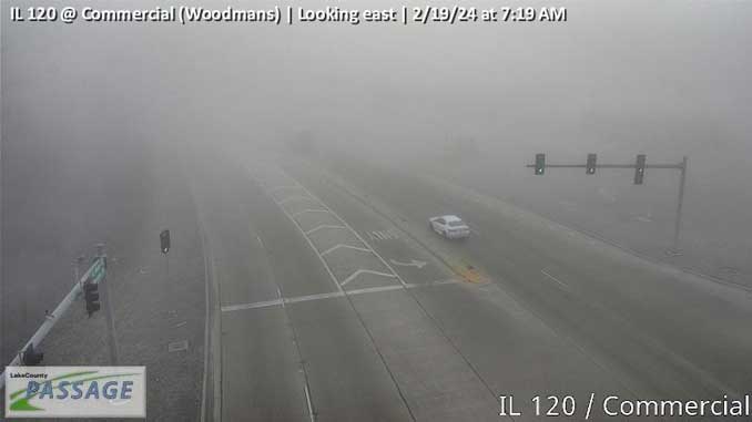
Patchy freezing fog occurred across portions of eastern McHenry, western Lake, and far northern Cook Counties in northeast Illinois Monday morning. Visibility may be reduced to a quarter mile or less in spots. With temperatures below freezing some patchy slick spots may develop, especially where visibility is lowest. Visibility is expected to improve by around 10 am.
Except for low-lying areas, visibility was O.K. near Arlington Heights with a very light fog at sunrise that burned off fast.
In Schaumburg and Streamwood, there were two rollover crashes in Schaumburg and one crash into utility pole Monday morning that were possibly related to weather with frost on the roadway from freezing fog in the air.
About 7:08 a.m., Schaumburg firefighters and paramedics worked at the scene of a rollover crash with injuries at Higgins Rd and Salem Dr Schaumburg. Report of a black Honda rolled over and crashed into a tree. Police first on the scene report the crash is westbound on Higgins Road near the Prince of Peace Church. Police report a female is out of the vehicle and is “OK.”
About 7:36 a.m., Schaumburg firefighters and paramedics worked at the scene of a rollover crash with injuries at Irving Park Rd and Springinsguth Rd Schaumburg. Report of a white Ford Transit involved in a crash with a black Jeep that is on its side. E53 on arrival reported that the crash was in the eastbound lanes at Springinsguth Road with a Jeep on its side.
A fire crew held up the extrication response and requested the second ambulance keep coming to the scene.
Eastbound Irving Park Road backed up past Mercury Drive.
About 9:06 a.m., Streamwood firefighters and paramedics worked at the scene of a vehicle vs pole crash at Woodland Heights Blvd and Sunnydale Blvd Streamwood. A fire crew on arrival reported a vehicle crash into utility pole.
News choppers crews did not share images this morning, and were apparently not in the air this morning.
Weather Radar in northeast Illinois was clear by 9:00 a.m.
See also Arlingtoncardinal.com/clouds
Highs this week start in the 40s and gradually rise into the 50s through mid-week. These are 5-10 degrees above typical values for this time of year. There is a chance of rain Wednesday night into Thursday, mainly south of I-80. #ilwx #inwx pic.twitter.com/MVCgcqvxeS
— NWS Chicago (@NWSChicago) February 19, 2024
O’HARE FORECAST …
Monday (Washington’s Birthday): Mostly sunny, with a high near 49. Calm wind becoming southwest around 5 mph in the afternoon. Winds could gust as high as 10 mph.
Tonight: Mostly clear, with a low around 29. South wind around 5 mph, with gusts as high as 15 mph.
Tuesday: Sunny, with a high near 52. South wind 5 to 10 mph, with gusts as high as 20 mph.
Tuesday Night: Partly cloudy, with a low around 36. South southwest wind 5 to 10 mph, with gusts as high as 20 mph.
Wednesday: Partly sunny, with a high near 55. South southwest wind 5 to 15 mph, with gusts as high as 20 mph.
Wednesday Night: A 20 percent chance of rain. Mostly cloudy, with a low around 40.
Thursday: A 20 percent chance of rain before noon. Mostly cloudy, with a high near 52.
Thursday Night: Mostly clear, with a low around 32.
Friday: Sunny, with a high near 42.
Friday Night: Mostly clear, with a low around 24.
Saturday: Sunny, with a high near 41.
Saturday Night: Mostly clear, with a low around 35.
Sunday: Sunny, with a high near 53.
LAKE TEMPS …
SOUTHERN LAKE MICHIGAN WATER TEMPERATURES
NATIONAL WEATHER SERVICE CHICAGO/ROMEOVILLE IL
902 AM CST Mon Feb 19 2024
LAKE MICHIGAN WATER TEMPERATURES…
CHICAGO SHORE………..37.
CHICAGO CRIB…………35.
MICHIGAN CITY………..36.
SOUTH MID LAKE BUOY…..40.
&&
M IS FOR MISSING DATA THAT IS NORMALLY AVAILABLE.
THE MICHIGAN CITY WATER TEMPERATURE SENSOR IS LOCATED AT
A WATER INTAKE ONE MILE OFFSHORE AND 60 FEET BELOW THE
WATER SURFACE. IT IS READ EVERY DAY OF THE YEAR.
february.chicagoweatherstation.com
Chicago Weather Forecast for your MAC/PC/TABLET includes surrounding suburbs.
^^ MOBILE? USE VOICE MIC ^^
facebook …
Please ‘LIKE’ the ‘Arlington Cardinal Page. See all of The Cardinal Facebook fan pages at Arlingtoncardinal.com/about/facebook …
Help fund The Cardinal Arlingtoncardinal.com/sponsor
Area Forecast Discussion National Weather Service Chicago/Romeoville, IL 606 AM CST Mon Feb 19 2024
.KEY MESSAGES…
– Warming temperatures over the next few days with 50s in store for the middle of the week
– A potential for some rain showers on Thursday, especially east of I-55
&&
.DISCUSSION… Issued at 315 AM CST Mon Feb 19 2024
Clear skies early this morning are about to be interrupted by a blanket of cirrus being advected in from the northwest on the lee of an approaching ridge. Temperatures have been a bit troublesome so far this morning with the area refusing to cool off consistently. A handful of sites, mainly across our northwest, have been down in the upper teens for a few hours now. Most of the area sits in the mid 20s as of around 3 AM. We`ll find ourselves in the upper teens/lower 20s on our way out the door this morning. Luckily, a calm wind means there`s not much of a wind chill factor to account for. It`s possible that some patchy fog could develop across our south as we approach daybreak, but nothing widespread or terribly dense is anticipated. Temperatures this afternoon should be similar to what we saw yesterday, perhaps a couple of degrees warmer, with highs forecast to reach the middle to upper 40s. There remains a little bit of snowpack across our far south which should kee Pthis part of the area a tad cooler once again today. Expect filtered sunshine today on account of the cirrus overhead and winds will remain rather light within a broad region of surface high pressure in place.
Just upstream of the cirrus plume, a potent little shortwave is digging over the northern High Plains with a region of circulation evident on water vapor imagery. Models continue to deamplify the wave quite considerably before it works across the Midwest tomorrow. By the time it moves overhead, moisture and forcing look too scarce to produce anything more than some added cloud cover. A second, more subtle shortwave is progged to move over on Wednesday. This one is more moisture-rich than the previous, but a lack forcing and some low level dry air should again keep the area dry. The operational Euro and a handful of its ensemble members have consistently wanted to produce some pockets of light precip, but such solutions are few and far between among guidance.
We`re still looking at Wednesday night and Thursday as being our best potential for seeing precip this week. An organized system of low pressure will trek across the lower Midwest. There is a consistent signal among models that a strengthening southwesterly LLJ atop the storm will stretch and elongate the low pressure center introducing a region of deformation and, in turn, higher preci Pprobs to areas northeast. The question that remains is whether this will begin to take place early enough to drop precip on the CWA before the system is too far off to our east. The Euro, NAM, and Canadian all have a pretty consistent signal that this process will really begin to ramp up right over or just downstream of our CWA. This solution appears to be the fan favorite among various ensembles as well and would favor a mostly dry forecast with areas east of I- 55 seeing the best chance for precip. The GFS, among others, is quicker to strengthen the LLJ and brings widespread showers to the area. While there`s enough support that this solution shouldn`t be discounted just yet, there is a notably stronger signal in favor of the former.
An upper trough axis will move across late Thursday which will pull temperatures back into the 40s for Friday and Saturday after spending the previous few days in the 50s. Broad surface high pressure should keep conditions pretty quiet through the weekend. Pleasantly mild conditions look to return by Sunday with all signs continuing to point toward a warm end to the month.
— Doom/NWS Chicago
