
A Winter Weather Advisory was issued at 3:00 a.m. Monday, January 8, 2024 for much of northern Illinois, effective 8:00 p.m. Monday to noon CST Tuesday, as a result of intensifying conditions forecast for Round 1 snowfall. While the snowfall total forecast for overnight Monday/Tuesday (Round 1) has increased, the snowfall total forecast for Tuesday afternoon/overnight Tuesday/early Wednesday has decreased for the Arlington Heights, Chicago O’Hare area.
The snow-rain line for Round 2 is subject to change, but currently the Round 2 event for Arlington Heights and O’Hare is looking like more of a rain event with some wet snow with less accumulation. Some concern about how a rainfall event on top of 5 inches of snow cover will affect hazards.
ROUND 1 Snow System
Monday 8:00 p.m. through Tuesday 11:00 a.m. … Weather hazards expected… Elevated Snow Risk. Arlington Heights/O’Hare snowfall forecast totals have increased to 5.3 inches (from a forecast issued Sunday of only 2 inches).
Snow will spread across Chicagoland during the mid to late
evening Monday. The snow may be heavy for a few hours, especially along and south of Interstate 55.
There will be a lull in snowfall during a rainy period near Arlington Heights and O’Hare International Airport from about 12:00 p.m. to 5:00 p.m.
ROUND 2 Snow System
Tuesday with increased rainy period 12:00 p.m. to 8:00 p.m. and wet snow period of less than one inch from 6:00 p.m. Tuesday to 5:00 a.m. Wednesday … Limited Non Thunderstorm Wind Risk. Significant Snow Risk. Round 2 snowfall total forecast is highly unpredictable at this point due to the difficulty of tracking the precise Rain/Snow line through northeast Illinois.
Areas, such as McHenry with a total snowfall forecast of about 7.5 inches, won’t experience a snowfall lull between Round 1 and Round 2; and will see a continuous snow period from 8:00 p.m. Monday to 5:00 a.m. Wednesday (33 hours of snowfall with little if any rain).
After ROUND 1 and ROUND 2
Wednesday Night… Limited Snow Risk. Friday and Saturday… Limited Non Thunderstorm Wind Risk. Elevated Snow Risk. Sunday… Limited Excessive Cold Risk.
Heavy wet snow is expected across northwest Illinois Tuesday where several inches are possible which may lead to hazardous and difficult travel. The snow is expected to mix with or change to rain southeast of Interstate 55 during the day, then change back to all snow Tuesday evening. Some low drifting snow will be possible Wednesday morning as northwest winds gust to 30 mph.
Another possible winter storm may affect the area Friday into Saturday bringing accumulating snow and strong winds.
Weather Radar in northeast Illinois was clear at 8:30 a.m.; however, precipitation is appearing in western Iowa and western Missouri. At the United States view, the storm has the comma shape with thunderstorms near Dallas on the south side of the system.
The low was centered over the Texas and Oklahoma panhandles Monday morning about 8:30 a.m.
See also Arlingtoncardinal.com/clouds
Here's a general overview of expected precipitation types, intensities, and timings. To use this slide, find your general area in the inset map and identify the number. Look at the associated line number on the graph at the right. (4/5) pic.twitter.com/EtW8YXoT48
— NWS Chicago (@NWSChicago) January 8, 2024
Round 2 occurs later Tue. AM/midday into the evening w/ focus shifting to areas NW of I-55/94. Some uncertainty regarding whether high snowfall rates will be prolonged in the orange & red-shaded areas, but individuals should prepare for dangerous travel conditions in NW IL. (3/5) pic.twitter.com/YkZrEMbmSc
— NWS Chicago (@NWSChicago) January 8, 2024
After this system departs tomorrow night, another period of gusty snow showers and minor accums psbl Wednesday night, and again Thursday night before a potentially more significant system approaches Fri night. (5/5) pic.twitter.com/c8wieH4vSV
— NWS Chicago (@NWSChicago) January 8, 2024
O’HARE FORECAST …
Monday: Cloudy, with a high near 34. South southeast wind 5 to 10 mph, with gusts as high as 15 mph.
Monday Night: Snow, mainly after 8pm. Low around 32. East southeast wind 10 to 15 mph, with gusts as high as 30 mph. Chance of precipitation is 100%. New snow accumulation of 2 to 4 inches possible.
Tuesday: Snow before 9am, then snow, possibly mixed with rain between 9am and noon, then rain after noon. Steady temperature around 33. Breezy, with an east southeast wind 10 to 20 mph becoming southwest in the afternoon. Winds could gust as high as 30 mph. Chance of precipitation is 100%. New snow accumulation of 1 to 3 inches possible.
Tuesday Night: Rain and snow, becoming all snow after 9pm. Low around 31. Blustery, with a west northwest wind 10 to 15 mph increasing to 15 to 20 mph after midnight. Winds could gust as high as 30 mph. Chance of precipitation is 90%. New snow accumulation of less than a half inch possible.
Wednesday: Mostly cloudy, with a high near 33. Breezy, with a west wind 15 to 20 mph, with gusts as high as 25 mph.
Wednesday Night: Snow likely, mainly after midnight. Mostly cloudy, with a low around 22. Chance of precipitation is 60%.
Thursday: A 20 percent chance of snow before noon. Partly sunny, with a high near 31.
Thursday Night: A chance of snow before midnight, then a chance of rain and snow. Mostly cloudy, with a low around 21.
Friday: Rain and snow likely, mainly after noon. Cloudy, with a high near 33. Breezy.
Friday Night: Snow likely. Cloudy, with a low around 20. Blustery.
Saturday: A chance of snow. Mostly cloudy, with a high near 25. Blustery.
Saturday Night: A chance of snow. Mostly cloudy, with a low around 6. Breezy.
Sunday: A chance of snow. Mostly cloudy, with a high near 13.
LAKE TEMPS …
SOUTHERN LAKE MICHIGAN WATER TEMPERATURES
NATIONAL WEATHER SERVICE CHICAGO/ROMEOVILLE IL
910 AM CST Sun Jan 7 2024
LAKE MICHIGAN WATER TEMPERATURES…
CHICAGO SHORE………..38.
CHICAGO CRIB…………39.
MICHIGAN CITY………..39.
SOUTH MID LAKE BUOY…..43.
&&
M IS FOR MISSING DATA THAT IS NORMALLY AVAILABLE.
THE MICHIGAN CITY WATER TEMPERATURE SENSOR IS LOCATED AT A WATER INTAKE ONE MILE OFFSHORE AND 60 FEET BELOW THE WATER SURFACE. IT IS READ EVERY DAY OF THE YEAR.
january.chicagoweatherstation.com
Chicago Weather Forecast for your MAC/PC/TABLET includes surrounding suburbs.
^^ MOBILE? USE VOICE MIC ^^
facebook …
Please ‘LIKE’ the ‘Arlington Cardinal Page. See all of The Cardinal Facebook fan pages at Arlingtoncardinal.com/about/facebook …
Help fund The Cardinal Arlingtoncardinal.com/sponsor
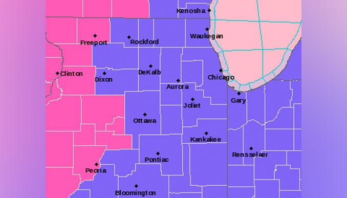
WINTER WEATHER ADVISORY …
URGENT – WINTER WEATHER MESSAGE
National Weather Service Chicago IL
300 AM CST Mon Jan 8 2024
ILZ013-020-021-023-032-103>108-INZ001-002-081800-
/O.NEW.KLOT.WW.Y.0001.240109T0200Z-240109T1800Z/
DuPage-Kendall-Grundy-Kankakee-Livingston-Northern Cook-
Central Cook-Southern Cook-Northern Will-Southern Will-
Eastern Will-Lake IN-Porter-
Including the cities of Naperville, Wheaton, Downers Grove,
Lombard, Carol Stream, Oswego, Yorkville, Plano, Morris,
Coal City, Minooka, Kankakee, Bourbonnais, Bradley, Pontiac,
Dwight, Fairbury, Evanston, Des Plaines, Schaumburg, Palatine,
Northbrook, Chicago, Cicero, Oak Lawn, Oak Park, La Grange,
Calumet City, Oak Forest, Lemont, Orland Park, Park Forest,
Joliet, Bolingbrook, Plainfield, Mokena, Channahon, Manhattan,
Wilmington, Crete, Peotone, Beecher, Gary, Hammond, Merrillville,
Portage, Valparaiso, and Chesterton
300 AM CST Mon Jan 8 2024
…WINTER WEATHER ADVISORY IN EFFECT FROM 8 PM THIS EVENING TO
NOON CST TUESDAY…
* WHAT…Wet snow expected. Total snow accumulations of 2 to 5
inches. Winds gusting as high as 30 mph.
* WHERE…Portions of central and northeast Illinois and northwest
Indiana including the Chicago Metro Area.
* WHEN…From 8 PM this evening to noon CST Tuesday.
* IMPACTS…Plan on slippery road conditions. The hazardous
conditions could impact the Tuesday morning commute.
* ADDITIONAL DETAILS…Snowfall rates of 1 to 2 inches per hour
are possible for a brief period late tonight. Visibilities under
one half mile are possible. Additional light snow accumulations
are expected Tuesday night.
PRECAUTIONARY/PREPAREDNESS ACTIONS…
Slow down and use caution while traveling.
In Illinois, the latest road conditions for Illinois can be
obtained on the internet at www.gettingaroundillinois.com. In
Indiana, the latest road conditions for Indiana are available by
calling 1-800-261-7623.
