
Current weather and news playlist (Also available at the top of CARDINAL NEWS front page: let it play, or use menu control, upper right ≡).
▷ NEWS PLAYLIST ≡
NEWS PLAYLIST after the Weather from Monday morning, August 14, 2023 …
1 man in critical condition, 3 others injured in Gold Coast shooting
1:40 on CBS Chicago
3 arrested after attacks on Lakefront Trail near Oak Street Beach
0:46 on CBS Chicago
Washington Park Mass Shooting: 18-year-old dead, 3 people injured
0:24 on CBS Chicago
4 people shot in busy area on Near North Side, Chicago police say
1:35 on ABC 7 Chicago
Woman stabbed at United Center on night of Lil Durk concert
0:43 on ABC 7 Chicago
Woman stabbed outside United Center in Chicago
0:21 on CBS Chicago
Mayor Johnson selects Larry Snelling as next Chicago police superintendent
2:20 on ABC 7 Chicago
Chicago Mayor Brandon Johnson chooses Larry Snelling as next CPD superintendent
2:15 on CBS Chicago
Naperville gun dealer appeals to US Supreme Court to lift assault weapon ban
0:58 on FOX 32 Chicago
Man allegedly lures minors near Chicago elementary school, police warn
1:52 on ABC 7 Chicago
Pritzker signs new bill preventing advertising of firearms
1:42 on CBS Chicago
Witnesses tackle driver who hit 5-year-old boy in crosswalk
1:50 on ABC 7 Chicago
Popular car show in Dolton abruptly cancelled
0:57 on FOX 32 Chicago
Firefighter remains hospitalized after basement fire on Northwest Side
0:21 on CBS Chicago
[LIST ABOVE: Most recent videos on the CARDINAL NEWS playlist Monday morning, August 14, 2023 at publishing time for this article. Always over 150 Chicagoland news videos are available in the video playlist (upper right ≡ menu). Works well to listen to the video playlist in the background, too.]
O’HARE FORECAST …
Flood Watch
Beach Hazards Statement
Hazardous Weather Outlook
[SEE MORE BELOW ADS]
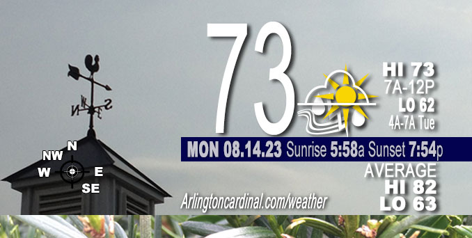
Monday: Showers and possibly a thunderstorm. Some of the storms could produce heavy rain. Temperature falling to around 68 by 4pm. East wind around 10 mph. Chance of precipitation is 90%. New rainfall amounts between a half and three quarters of an inch possible.
Monday Night: Showers and thunderstorms before 4am, then a chance of showers. Some of the storms could produce heavy rain. Low around 62. North wind 10 to 15 mph, with gusts as high as 25 mph. Chance of precipitation is 80%. New rainfall amounts between a quarter and half of an inch possible.
Tuesday: Mostly cloudy, then gradually becoming sunny, with a high near 76. North wind 10 to 15 mph, with gusts as high as 20 mph.
Get updates from The Cardinal ALL NEWS FEEDS on Facebook. Just ‘LIKE’ the ‘Arlington Cardinal Page (become a fan of our page). The updates cover all posts and sub-category posts from The Cardinal — Arlingtoncardinal.com. You can also limit feeds to specific categories. See all of The Cardinal Facebook fan pages at Arlingtoncardinal.com/about/facebook …
Help fund The Cardinal Arlingtoncardinal.com/sponsor
O’HARE FORECAST …
Flood Watch
Flood Watch Flood Watch National Weather Service Chicago IL 320 AM CDT Mon Aug 14 2023
McHenry-Lake IL-Kane-DuPage-Northern Cook-Central Cook-Southern Cook- Including the cities of Buffalo Grove, Oak Park, Elgin, Downers Grove, Wheaton, Calumet City, Lombard, Carol Stream, Park Forest, Woodstock, Gurnee, Oak Forest, Crystal Lake, Evanston, Oak Lawn, Mundelein, Schaumburg, Aurora, La Grange, Palatine, Algonquin, Waukegan, Orland Park, Chicago, Northbrook, Lemont, Naperville, McHenry, Des Plaines, and Cicero 320 AM CDT Mon Aug 14 2023
…FLOOD WATCH IN EFFECT FROM 10 AM CDT THIS MORNING THROUGH THIS EVENING…
* WHAT…Flash flooding caused by excessive rainfall is possible.
* WHERE…A portion of northeast Illinois, including the following areas, Central Cook, DuPage, Kane, Lake IL, McHenry, Northern Cook and Southern Cook.
* WHEN…From 10 AM CDT this morning through this evening.
* IMPACTS…Creeks and streams may rise out of their banks. Flooding may occur in poor drainage and urban areas. Underpasses may be flooded.
* ADDITIONAL DETAILS… – Periods of heavy rainfall will accompany showers and thunderstorms today across northeastern Illinois. Rainfall rates in excess of an inch per hour are likely with the heaviest showers, and this may lead to instances of flash flooding. – http://www.weather.gov/safety/flood
PRECAUTIONARY/PREPAREDNESS ACTIONS…
A Flood Watch for flash flooding means rapid-onset flooding is possible, but not yet certain, based upon the latest forecasts. Flash flooding is a dangerous situation. Persons with interests along area rivers, creeks, and other waterways should monitor the latest forecasts and be prepared to take action should flooding develop.
Beach Hazards Statement
Beach Hazards Statement Coastal Hazard Message National Weather Service Chicago IL 949 AM CDT Mon Aug 14 2023
Lake IL-Northern Cook-Central Cook- 949 AM CDT Mon Aug 14 2023
…BEACH HAZARDS STATEMENT REMAINS IN EFFECT FROM 4 PM CDT THIS AFTERNOON THROUGH TUESDAY EVENING…
* WHAT…High wave action and dangerous currents expected at Lake Michigan beaches. Waves 6 to 9 ft expected.
* WHERE…Lake IL, Northern Cook and Central Cook Counties.
* WHEN…From 4 PM CDT this afternoon through Tuesday evening.
* IMPACTS…Swimming conditions will be life threatening, especially for inexperienced swimmers. For information on swim advisories or bans at Chicago beaches: www. cpdbeaches. com.
PRECAUTIONARY/PREPAREDNESS ACTIONS…
Remain out of the water to avoid dangerous swimming conditions and do not venture out onto piers, jetties, breakwalls, or other shoreline structures.
&&
$$
Hazardous Weather Outlook
Hazardous Weather Outlook Hazardous Weather Outlook National Weather Service Chicago/Romeoville IL 358 AM CDT Mon Aug 14 2023
ILZ003>006-008-010>013-019>021-023-032-033-039-103>108-INZ001-002- 010-011-019-150900- Winnebago-Boone-McHenry-Lake IL-Ogle-Lee-De Kalb-Kane-DuPage- La Salle-Kendall-Grundy-Kankakee-Livingston-Iroquois-Ford- Northern Cook-Central Cook-Southern Cook-Northern Will- Southern Will-Eastern Will-Lake IN-Porter-Newton-Jasper-Benton- 358 AM CDT Mon Aug 14 2023 /458 AM EDT Mon Aug 14 2023/
This Hazardous Weather Outlook is for portions of North Central Illinois…Northeast Illinois and Northwest Indiana.
.DAY ONE…Today and Tonight.
Weather hazards expected…
Limited Thunderstorm Risk…with an associated: Limited Tornado Risk. Limited Hail Risk…up to penny size. Limited Damaging Wind Risk…up to 60 mph. Elevated Flooding Risk. High Swim Risk Lake Michigan Shore
DISCUSSION…
Periods of showers and thunderstorms are expected today from mid morning into this evening. There is a small threat of severe thunderstorms capable of producing isolated tornadoes and damaging winds. In addition, locally heavy rainfall may result in instances of flash flooding, particularly across northeastern Illinois north of I-80.
In the wake of this system, breezy onshore winds are expected to result in large waves and hazardous swimming conditions for Lake Michigan beaches late this afternoon and tonight.
.DAYS TWO THROUGH SEVEN…Tuesday through Sunday.
Tuesday… High Swim Risk Lake Michigan Shore Thursday… Limited Thunderstorm Risk. Sunday… Limited Excessive Heat Risk.
.SPOTTER INFORMATION STATEMENT…
Spotters may be needed later this morning into the afternoon.
GENERAL STORM MOTION OF THE DAY:
Moving toward the east northeast 20 to 30 mph
$$
O’HARE FORECAST …
Monday: Showers and possibly a thunderstorm. Some of the storms could produce heavy rain. Temperature falling to around 68 by 4pm. East wind around 10 mph. Chance of precipitation is 90%. New rainfall amounts between a half and three quarters of an inch possible.
Monday Night: Showers and thunderstorms before 4am, then a chance of showers. Some of the storms could produce heavy rain. Low around 62. North wind 10 to 15 mph, with gusts as high as 25 mph. Chance of precipitation is 80%. New rainfall amounts between a quarter and half of an inch possible.
Tuesday: Mostly cloudy, then gradually becoming sunny, with a high near 76. North wind 10 to 15 mph, with gusts as high as 20 mph.
Tuesday Night: Mostly clear, with a low around 58. North northeast wind around 5 mph becoming calm in the evening. Winds could gust as high as 10 mph.
Wednesday: Sunny, with a high near 82. Southwest wind 5 to 10 mph.
Wednesday Night: Partly cloudy, with a low around 66. Breezy.
Thursday: A 40 percent chance of showers and thunderstorms before 1pm. Mostly sunny, with a high near 83. Breezy.
Thursday Night: Mostly clear, with a low around 62.
Friday: Sunny, with a high near 83.
Friday Night: Mostly clear, with a low around 66.
Saturday: Sunny, with a high near 91.
Saturday Night: Partly cloudy, with a low around 71.
Sunday: Mostly sunny, with a high near 91.
