
NWS radar approximately 5:30 PM to 7 PM Thursday, July 13, 2023. YouTube Tips ⓘ
A surprise Tornado Warning was activated at 6:59 p.m. Thursday, July 13, 2023. By 8:00 p.m. the storm cell was dissipating of Lake County and eastern McHenry County.
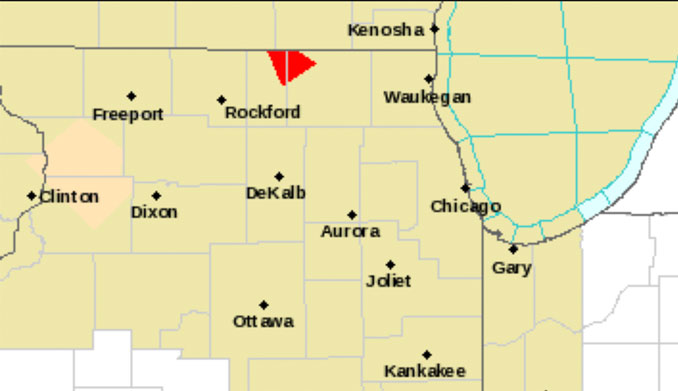
Tornado Warning including Harvard IL, Capron IL and Chemung IL until 7:30 PM CDT ….
Tornado Warning
Severe Weather Statement National Weather Service Chicago/Romeoville 659 PM CDT
Thu Jul 13 2023
McHenry IL-Boone IL- 659 PM CDT Thu Jul 13 2023
…A TORNADO WARNING REMAINS IN EFFECT UNTIL 730 PM CDT FOR NORTHWESTERN MCHENRY AND NORTHEASTERN BOONE COUNTIES…
At 659 PM CDT, a severe thunderstorm capable of producing a tornado was located over Sharon, or 7 miles northwest of Harvard, moving southeast at 15 mph.
HAZARD…Tornado.
SOURCE…Radar indicated rotation.
IMPACT…Flying debris will be dangerous to those caught without shelter. Mobile homes will be damaged or destroyed. Damage to roofs, windows, and vehicles will occur. Tree damage is likely.
Locations impacted include… Harvard, Capron and Chemung.
PRECAUTIONARY/PREPAREDNESS ACTIONS…
TAKE COVER NOW! Move to a basement or an interior room on the lowest floor of a sturdy building. Avoid windows. If you are outdoors, in a mobile home, or in a vehicle, move to the closest substantial shelter and protect yourself from flying debris.
&&
LAT…LON 4243 8852 4233 8873 4249 8882 4249 8863 TIME…MOT…LOC 2359Z 318DEG 14KT 4249 8872
TORNADO…RADAR INDICATED MAX HAIL SIZE…0.00 IN
Weather Radar shows storms in northern Illinois and southern Wisconsin moving northwest to southeast around 7:00 p.m.
See also Arlingtoncardinal.com/clouds
Tornado Warning including Harvard IL, Chemung IL and Hartland IL until 8:00 PM CDT pic.twitter.com/7l9MRJfNUb
— NWS Tornado (@NWStornado) July 14, 2023
Tornado Warning including Harvard IL, Capron IL and Chemung IL until 7:30 PM CDT pic.twitter.com/I5G9xk66el
— NWS Chicago (@NWSChicago) July 13, 2023
Tornado Warning continues for Sharon WI until 7:15 PM CDT pic.twitter.com/GUG8Nti0aA
— NWS Tornado (@NWStornado) July 13, 2023
O’HARE FORECAST …
Tonight: A chance of showers and thunderstorms before midnight, then a slight chance of showers and thunderstorms after 2am. Partly cloudy, with a low around 67. South wind around 5 mph becoming west southwest after midnight. Winds could gust as high as 15 mph. Chance of precipitation is 40%.
Friday: A 30 percent chance of showers and thunderstorms, mainly before 3pm. Mostly sunny, with a high near 86. Southwest wind 5 to 15 mph, with gusts as high as 20 mph.
Friday Night: A 50 percent chance of showers and thunderstorms. Mostly cloudy, with a low around 68. West southwest wind 5 to 10 mph.
Saturday: A 50 percent chance of showers and thunderstorms. Partly sunny, with a high near 85. Southwest wind 5 to 10 mph, with gusts as high as 15 mph.
Saturday Night: Mostly clear, with a low around 66. West wind around 5 mph, with gusts as high as 10 mph.
Sunday: A 30 percent chance of showers and thunderstorms after 1pm. Sunny, with a high near 83.
Sunday Night: A chance of showers and thunderstorms. Partly cloudy, with a low around 64. Chance of precipitation is 40%.
Monday: A chance of showers after 1pm. Mostly sunny, with a high near 80.
Monday Night: Mostly clear, with a low around 61.
Tuesday: Sunny, with a high near 81.
Tuesday Night: A chance of showers. Partly cloudy, with a low around 65.
Wednesday: A chance of showers. Mostly sunny, with a high near 84.
Wednesday Night: A chance of showers. Mostly cloudy, with a low around 68.
Thursday: A chance of showers. Partly sunny, with a high near 84.
LAKE TEMPS …
SOUTHERN LAKE MICHIGAN WATER TEMPERATURES
NATIONAL WEATHER SERVICE CHICAGO/ROMEOVILLE IL
ISSUED BY NATIONAL WEATHER SERVICE MILWAUKEE/SULLIVAN WI
913 AM CDT Thu Jul 13 2023
LAKE MICHIGAN WATER TEMPERATURES…
CHICAGO SHORE………..69.
CHICAGO CRIB…………68.
CHICAGO BUOY…………70.
WILMETTE BUOY………..69.
WAUKEGAN BUOY………..68.
WINTHROP HARBOR BUOY….65.
MICHIGAN CITY………..64.
MICHIGAN CITY BUOY……70.
SOUTH MID LAKE BUOY…..66.
CENTRAL MID LAKE BUOY…65.
NORTH MID LAKE BUOY…..63.
&&
M IS FOR MISSING DATA THAT IS NORMALLY AVAILABLE.
THE MICHIGAN CITY WATER TEMPERATURE SENSOR IS LOCATED AT A WATER
INTAKE ONE MILE OFFSHORE AND 60 FEET BELOW WATER SURFACE. IT IS READ
EVERY DAY OF THE YEAR.
Area Forecast Discussion National Weather Service Chicago/Romeoville, IL 636 PM CDT Thu Jul 13 2023
.SHORT TERM… Issued at 151 PM CDT Thu Jul 13 2023
Through Friday night…
Key Messages:
* High uncertainty in shower/storm chances tonight through Friday morning. * Chances for showers/storms largely restricted to the far northern parts of the CWA this evening through Friday morning. * Better chance for more widespread convection Friday late afternoon evening.
A lot of uncertainty in the forecast through tonight but it does appear as though we will become unstable enough to get a few thunderstorms. The uncertainty lies primarily in the forcing later this afternoon into the early evening. While the focus for forcing may be best to the north and west of the area with some decent 850mb WAA and possibly a bit of a surface troughing but we could see some storms/showers sneak into the northern parts of the area by the early to mid evening. CAMs suggest high levels of uncertainty with the HRRR essentially not showing anything while the NAM-4km and WRF- ARW showing some activity across the northern parts of the area through the evening. The forcing in this scenario is quite uncertain as to whether it will be enough but current diurnal cu and some showers/storm development in IA and WI suggest it will likely not take much to give us a few storms, as even outflows may be enough.
Later overnight the scenario changes a bit. The 850mb jet and an UL shortwave while weak may be enough to bring enough UVM to bring some storms late overnight into the early morning. However the better chances may be closer to the mid morning hours when confluent flow in the low levels may be enough to bring some showers/storms especially if we see enough moisture transport (which is a bit more uncertain). Elevated instability will be available despite not being the greatest timing so we could see some storms. This continues through the morning hours and while the corridor for best chances remains fairly small located in far northern IL, along the IL/WI border, several models support these chances though there remains uncertainty on how long it may last. In the CAMs the HRRR is really the only model showing the better potential for the early morning chances migrating to the more narrow area of potential though some additional models has the narrower band of showers/storms. Given the plausibility of what we see in the HRRR we have some po Ppotential through Friday morning and even into the afternoon but the uncertainty brings us nothing more than chances. There should be a break in the potential by the mid afternoon across far northern IL.
Right as the convection over the northern IL is pushing out/ending we will begin watching the southwest part of the area for developing storms. A decent UL shortwave may largely be the trigger for this convection. CAMs do not project much organization to this convection and deep layer shear largely being below 30 kts should prevent much in the way of any severe weather chances but there should be plenty of instability to work with. The convection should persist through a decent portion of the night given the continual shortwave activity. With at least modest instability lingering through the overnight period, storm chances may persist and linger into the early morning before likely pushing out by mid morning Saturday.
aidan.kuroski
july.chicagoweatherstation.com
Chicago Weather Forecast for your MAC/PC/TABLET includes surrounding suburbs.
^^ MOBILE? USE VOICE MIC ^^
facebook …
Please ‘LIKE’ the ‘Arlington Cardinal Page. See all of The Cardinal Facebook fan pages at Arlingtoncardinal.com/about/facebook …
Help fund The Cardinal Arlingtoncardinal.com/sponsor
20240105-1435future
