
Live breakdown with multiple tornado warnings in effect in southern Wisconsin! Severe weather event is underway. This is a live, in-depth breakdown of the severe weather event already in progress. YouTube Tips ⓘ
The National Weather Service Milwaukee put out a forecast about 4:15 a.m. Wednesday morning, October 12, 2022 that residents in central and southern Wisconsin should expect a few stronger storms with gusts to 40 MPH, small hail, and brief heavy downpours. At about 11:28 a.m. a Tornado Warning was issued for an area including Concord, Dousman, Helenville, Johnson Creek, Ottawa, Rome, and Sullivan.
A debris signature was detected on radar southeast of La Grange, Wisconsin almost half way between LaGrange and Elkhorn, Wisconsin.
Several additional Tornado Warnings were issued — all were “radar indicated.” Areas included the following communities, beginning with the most recent …
Kenosha WI, Racine WI and Waukesha WI
Milwaukee WI, West Allis WI and Wauwatosa WI
Mequon WI and Thiensville WI
Waukesha WI, New Berlin WI and Brookfield WI
Whitewater WI, Elkhorn WI and Lake Geneva WI
Oconomowoc WI, Hartland WI and Delafield WI
Johnson Creek WI, Dousman WI and Rome WI
FOLLOWING ARE RELATED TWEETS FROM OLDEST TO NEWEST …
415AM | Showers and thunderstorms continue to impact central and southern Wisconsin early this morning, with the potential for a few stronger storms. #wiwx pic.twitter.com/pLM15lCSNF
— NWS Milwaukee (@NWSMilwaukee) October 12, 2022
Tornado Warning including Johnson Creek WI, Dousman WI and Rome WI until 12:00 PM CDT pic.twitter.com/65muLWn58w
— NWS Milwaukee (@NWSMilwaukee) October 12, 2022
Tornado Warning including Oconomowoc WI, Hartland WI and Delafield WI until 12:00 PM CDT pic.twitter.com/IsYuiBQ1jo
— NWS Milwaukee (@NWSMilwaukee) October 12, 2022
Tornado Warning including Whitewater WI, Elkhorn WI and Lake Geneva WI until 12:15 PM CDT pic.twitter.com/cH5jhbCa69
— NWS Milwaukee (@NWSMilwaukee) October 12, 2022
Tornado Warning including Waukesha WI, New Berlin WI and Brookfield WI until 12:15 PM CDT pic.twitter.com/gGH9ZIKill
— NWS Milwaukee (@NWSMilwaukee) October 12, 2022
Tornado Warning including Mequon WI and Thiensville WI until 12:30 PM CDT pic.twitter.com/2zhAoL3wct
— NWS Milwaukee (@NWSMilwaukee) October 12, 2022
Tornado Warning including Milwaukee WI, West Allis WI and Wauwatosa WI until 12:45 PM CDT pic.twitter.com/JSYo1SweZC
— NWS Milwaukee (@NWSMilwaukee) October 12, 2022
Tornado Warning including Kenosha WI, Racine WI and Waukesha WI until 1:00 PM CDT pic.twitter.com/Ws1D5QIDWB
— NWS Milwaukee (@NWSMilwaukee) October 12, 2022
LIVE ALERTS ON TORNADOES FROM THE NATIONAL WEATHER SERVICE …
@NWStornado …
A Severe Thunderstorm Warnings were also issued for northern Lake County and McHenry County, where both Severe Thunderstorm Warnings indicated the development of a tornado was possible.
SEVERE THUNDERSTORM WARNING REMAINS IN EFFECT UNTIL 130 PM CDT FOR NORTHEASTERN LAKE COUNTY…
At 106 PM CDT, severe thunderstorms were located along a line extending from 7 miles southeast of Racine to Winthrop Harbor to near
Gurnee to near Mundelein, moving east at 35 mph.
HAZARD…Locally 60 mph wind gusts.
SOURCE…Radar indicated.
IMPACT…Expect damage to roofs, siding, and trees.
Locations impacted include…
Waukegan, North Chicago, Gurnee, Mundelein, Zion, Grayslake, Libertyville, Lake Forest, Lindenhurst, Beach Park, Gages Lake, Park City, Round Lake Park, Winthrop Harbor, Lake Bluff, Grandwood Park, Green Oaks, Wadsworth, Venetian Village and Third Lake.
This includes… College of Lake County, Great Lakes Naval Training Center, Lake County Fielders Baseball, Lake County IL Fairgrounds, Lake Forest College, and Six Flags Great America.
Including the following interstates…
I-94 between mile markers 1 and 16.
I-294 between mile markers 1 and 16.
TORNADO…POSSIBLE
HAIL THREAT…RADAR INDICATED
MAX HAIL SIZE…<.75 IN WIND THREAT...RADAR INDICATED MAX WIND GUST...60 MPH Storm Prediction Center Outlook …
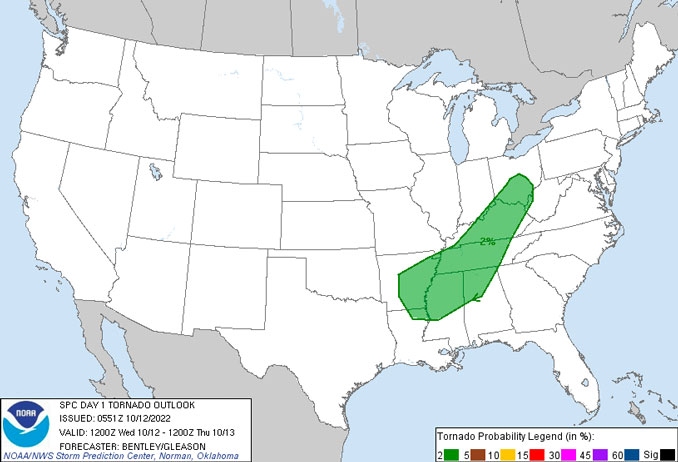
The Day 1 Convective Outlook from the NOAA Storm Prediction Center did not indicate a possibility of tornadoes in Wisconsin between 7:00 a.m. and 7:00 p.m. Wednesday, October 12, 2022.
Possible tornadoes were indicated for Louisiana, Arkansas, Alabama, Mississippi, far northwest Georgia, Tennessee, Kentucky, far southern Indiana, southern Ohio, and far west West Virginia in the alert issued12:51 a.m. Wednesday, October 12, 2022.
A “squall line” refers to a linearly-oriented zone of convection (i.e., thunderstorms). Squall lines are common across the United States east of the Rockies, especially during the spring when the atmosphere is most “dynamic.” A “bow echo” or “bowing line segment” is an arched/bowed out line of thunderstorms, sometimes embedded within a squall line. All these terms fall under the more generic term Quasi-Linear Convective System (QLCS). Bow echoes, most common in the spring and summer, usually are associated with an axis of enhanced winds that create straight-line wind damage at the surface. In fact, bow echo-induced winds/downbursts account for a large majority of the structural damage resulting from convective non-tornadic winds. Transient tornadoes also can occur in squall lines, especially in association with bow echoes. These tornadoes, however, tend to be weaker and shorter-lived on average than those associated with supercell thunderstorms. Severe squall lines and bow echoes are quite common in the Ohio Valley, including Kentucky. A sequence of WSR-88D Doppler radar images and discussions from some squall line/bow echo events across Kentucky and south-central Indiana are available to complement this document. Detailed squall line and bow echo information is given below, including pre-storm environments, and WSR-88D radar reflectivity, velocity, and mesocyclone characteristics.
^^ MOBILE? USE VOICE MIC ^^
facebook …
Please ‘LIKE’ the ‘Arlington Cardinal Page. See all of The Cardinal Facebook fan pages at Arlingtoncardinal.com/about/facebook …
Help fund The Cardinal Arlingtoncardinal.com/sponsor
20240105-1435future
