
Radar indicates severe weather is tracking across southern and central Wisconsin while inbound Chicagoland precipitation images located south of Rockford appear to be building, then diminishing. In other words, unless something develops fast, or the Wisconsin storms turn southeast, we’re going to see weak storms or scattered thundershowers in Chicagoland.
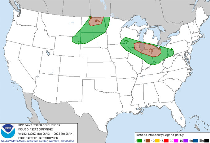
According to the National Weather Service Storm Prediction Center, new storms will intensify by early afternoon over southern Wisconsin and northern Illinois and rapidly become severe. These storms will track across Lake Michigan and into portions of Lower Michigan, and northern Indiana and Ohio during the afternoon. Possibly, a long-lived bowing Mesoscale Convective System (MCS) could result in a swath of considerable wind damage along this corridor. The precise track is uncertain, because recent Convection-Allowing Models (CAM) solutions continue to vary on the details of the track. Chicagoland is included in and Enhanced Area (ENH area) to address this threat.
Along with the damaging winds, the strongest cells may produce large hail and a few tornadoes. Northeast Illinois is an area where there is a 5% probability of a tornado within 25 miles of where a person is located, according to the National Weather Service Storm Prediction Center.
Just before 11:00 a.m. Mesoscale Convective Vortices (MCV’s) — low-pressure centers within an MCS that pull winds into a circling pattern, or vortex — were located in northeast Iowa, according to the National Weather Service. Warm temperatures with an unstable air mass was located to our south and is moving north.
The specific storm target area was uncertain at 11:00 a.m. and the precise path of storm depends on the timing of development. An earlier development over far western Wisconsin would place our
area in the crosshairs, while a later development over eastern
Wisconsin would favor a path entirely outside our area that would target Lower Michigan, according to the National Weather Service office Chicago.
Weather Radar shows at 12:00 p.m. that storms just began to develop with frequent lightning in southwest Wisconsin just just across the Illinois-Wisconsin state line north-northwest of Rockford. The storms are moving west-northwest. Another area of severe weather was passing the Wisconsin Dells moving west-northwest at 12:00 p.m.
The two areas of storms were initially consistent with prognostic storm tracks indicated by the National Weather Service Chicago office at 5:01 a.m. Monday morning. However, the radar image at 12:15 p.m. did not show extension south into Illinois, and the southern area of storms in southwest Wisconsin has weakened.
See also Arlingtoncardinal.com/clouds
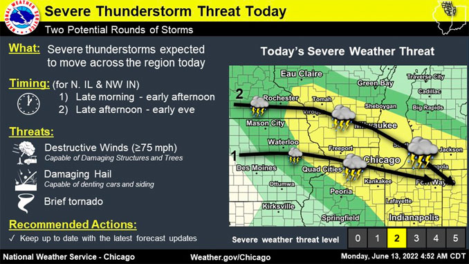
Two rounds of severe storms possible today. The first will be developing while crossing the area very late morning into early afternoon. The second may clip far NE IL and NW IN late afternoon into early eve. Main threat of damaging winds. Large hail, brief tornado also possible. pic.twitter.com/gmnwdQLr99
— NWS Chicago (@NWSChicago) June 13, 2022
Here is a look at the timing and potential coverage of each round of storms today. pic.twitter.com/TlFpd7s2eh
— NWS Chicago (@NWSChicago) June 13, 2022
O’HARE FORECAST …
This Afternoon: A 40 percent chance of showers and thunderstorms, mainly after 2pm. Mostly cloudy, with a high near 85. Southeast wind around 15 mph, with gusts as high as 20 mph.
Tonight: A 20 percent chance of showers and thunderstorms before 10pm. Partly cloudy, with a low around 72. South southeast wind 5 to 15 mph.
Tuesday: Sunny and hot, with a high near 97. Heat index values as high as 104. South southwest wind 10 to 15 mph, with gusts as high as 25 mph.
Tuesday Night: Mostly clear, with a low around 80. South southwest wind 10 to 15 mph, with gusts as high as 20 mph.
Wednesday: A 20 percent chance of showers and thunderstorms after 1pm. Sunny and hot, with a high near 97. South southwest wind 10 to 15 mph, with gusts as high as 25 mph.
Wednesday Night: A 50 percent chance of showers and thunderstorms. Partly cloudy, with a low around 74.
Thursday: Mostly sunny, with a high near 91.
Thursday Night: Mostly clear, with a low around 68.
Friday: Sunny, with a high near 84.
Friday Night: Clear, with a low around 60.
Saturday: Sunny, with a high near 82.
Saturday Night: Mostly clear, with a low around 63.
Sunday: Sunny, with a high near 89.
LAKE TEMPS …
SOUTHERN LAKE MICHIGAN WATER TEMPERATURES
NATIONAL WEATHER SERVICE CHICAGO/ROMEOVILLE IL
900 AM CDT Mon Jun 13 2022
LAKE MICHIGAN WATER TEMPERATURES…
CHICAGO SHORE………56.
CHICAGO CRIB……….62.
CHICAGO BUOY……….61.
WILMETTE BUOY……….59.
WAUKEGAN BUOY……….57.
WINTHROP HARBOR BUOY……….56.
MICHIGAN CITY……….52.
MICHIGAN CITY BUOY………..62.
SOUTH MID LAKE BUOY……….53.
NORTH MID LAKE BUOY……….39.
&&
M IS FOR MISSING DATA THAT IS NORMALLY AVAILABLE.
THE MICHIGAN CITY WATER TEMPERATURE SENSOR IS LOCATED AT A WATER
INTAKE ONE MILE OFFSHORE AND 60 FEET BELOW WATER SURFACE. IT IS READ
EVERY DAY OF THE YEAR.
june.chicagoweatherstation.com
Chicago Weather Forecast for your MAC/PC/TABLET includes surrounding suburbs.
^^ MOBILE? USE VOICE MIC ^^
facebook …
Please ‘LIKE’ the ‘Arlington Cardinal Page. See all of The Cardinal Facebook fan pages at Arlingtoncardinal.com/about/facebook …
Help fund The Cardinal Arlingtoncardinal.com/sponsor
20240105-1435future
