
VIDEO LIVE STREAM OF SNOWFALL WITH NWS CHICAGO AUDIO FROM “NOAA ALL HAZARDS WEATHER RADIO”
Winter Storm Warning Mode Jan. 1-2, 2022 LIVE VIDEO Snow Accumulation, NWS Chicago Audio 162.55 MHz (Part 2 of 2). YouTube Tips ⓘ
Winter Storm Warning Mode January 1, 2022 LIVE VIDEO Snow Accumulation, NWS Chicago Audio 162.55 MHz already showing that over 5 inches of snow fell between 12:00 p.m. and 7:00 p.m. Saturday (Part 1 of 2). YouTube Tips ⓘ
Arlington Heights and nearby communities are forecast to see another 4.5 inches of snow accumulation on top of about 5.0 inches of snowfall that has already fallen Saturday, January 1, 2022. Snow accumulation was about 5 inches at 6:10 p.m. and is almost The snow is dry and fluffy and relatively easy to shovel compared to more dangerous heavy, wet snow. The Winter Storm Warning is expected to continue to be in effect until 6:00 a.m. for Lake County, Illinois; DuPage County; Cook County and Lake County, Indiana.
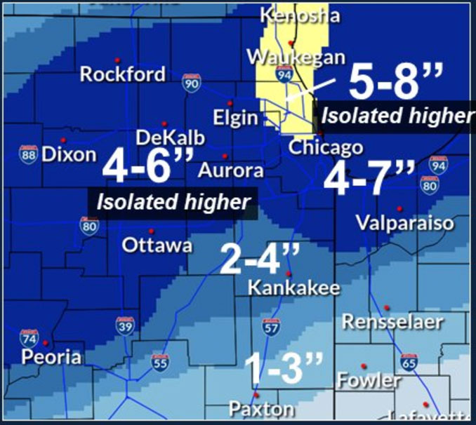
The forecast for storm total snowfall amounts near Lake Michigan haven’t changed materially with 5 to up to 9 inches. Arlington Heights and nearby suburbs may see totals around 9 inches with additional snow coming from northwest Illinois and lake effect snow overnight. However, south of I-80 the forecast accumulation has trended downward where low-quality snow and an incoming dryslot from Missouri are expected to cut into overall total amounts of snow, according to the NWS Chicago office. Forecast soundings south of I-80 later this evening show the southern area losing the better saturation above 600 mb after about 8-9 PM, leaving a saturated lower troposphere that’s all warmer than about -8 C. This suggests precipitation type may begin to transition to light snow and patchy freezing drizzle, further cutting down on totals.
The next concern is still bitter cold air heading into Sunday night. Temperatures are already at a downward trend with at 25°F reading at 6:40 p.m. Saturday. The cold air will conquer, considering weather guidance suggesting clear skies, calming winds, and some snowpack solidly in place in our are that will reflect and release heat energy into the atmosphere. According to the National Weather Service, temperatures could tank into the single digits below zero across interior parts of northern/northwest Illinois. Winds chills of -15°F are also possible. Currently, the lowest outlook is a -4°F Wind Chill around 5:00 a.m. Monday morning.
Weather Radar) shows snow precipitation over much of most of northern Illinois moving from southwest to northeast at 6:10 p.m. Arlington Heights and the northwest suburbs might see a little gap in snowfall in the 7 o’clock hour, according to weather radar. However, snow appears to be building in Ogle County and Lee Coutny and heading our way.
See also Arlingtoncardinal.com/clouds
[4:30 P.M. Sat 1/1] Snow continues and will be heavy at times especially through 9 to 10 p.m. After that point, the occasional heavy snow should focus along the lakefront. Totals up to near 3” have been reported so far in parts of north central Illinois. #ILwx #INWx pic.twitter.com/JigaCNAFZ4
— NWS Chicago (@NWSChicago) January 1, 2022
The combination of accumulating snow, at times heavy rates, the blowing snow, and the falling temperatures have made for hazardous travel conditions that will expand after dark. Use heightened caution if you have to travel. #ILwx #INwx https://t.co/AxOGkZgVt9 pic.twitter.com/KpwEz9mH7G
— NWS Chicago (@NWSChicago) January 1, 2022
[3:47 PM 1/1/2022] Snow continues across the area into this evening and this will at times be heavy, and in open locations be accompanied with some shallow blowing snow. Travel is hazardous across the area seeing snow. #ILwx #INwx pic.twitter.com/8KO9Eofeow
— NWS Chicago (@NWSChicago) January 1, 2022
[3:25 PM 1/1/2022] Steady snow with heavier bursts will continue across the area this afternoon, gradually easing with time tonight. Lake-enhanced snowfall will continue for lake-adjacent areas through the night. Avoid non-essential travel this evening. #ILwx #INwx pic.twitter.com/HEiQbpsjZJ
— NWS Chicago (@NWSChicago) January 1, 2022
O’HARE FORECAST …
Tonight: Snow, mainly before 5am. Patchy blowing snow before midnight. Low around 18. Blustery, with a north northeast wind 15 to 20 mph, with gusts as high as 30 mph. Chance of precipitation is 100%. Total nighttime snow accumulation of 3 to 5 inches possible.
Sunday: Mostly cloudy, then gradually becoming sunny, with a high near 22. Northwest wind 10 to 15 mph, with gusts as high as 20 mph.
Sunday Night: Mostly clear, with a low around 3. Wind chill values as low as -4. Northwest wind around 5 mph.
Monday: Sunny, with a high near 24. Wind chill values as low as -3. South southwest wind 5 to 15 mph.
Monday Night: Mostly clear, with a low around 19. South southwest wind around 10 mph, with gusts as high as 15 mph.
Tuesday: Partly sunny, with a high near 35.
Tuesday Night: Mostly cloudy, with a low around 17.
Wednesday: Mostly cloudy, with a high near 24. Breezy.
Wednesday Night: A slight chance of snow. Mostly cloudy, with a low around 10.
Thursday: A chance of snow. Mostly cloudy, with a high near 16.
Thursday Night: A slight chance of snow. Mostly cloudy, with a low around 0.
Friday: Mostly sunny, with a high near 12.
Friday Night: Mostly cloudy, with a low around 3.
Saturday: A slight chance of snow. Mostly cloudy, with a high near 29.
LAKE TEMPS …
SOUTHERN LAKE MICHIGAN WATER TEMPERATURES
NATIONAL WEATHER SERVICE CHICAGO/ROMEOVILLE IL
905 AM CST Sat Jan 1 2022
LAKE MICHIGAN WATER TEMPERATURES…
CHICAGO SHORE……….43.
CHICAGO CRIB……….42.
MICHIGAN CITY……….42.
&&
M IS FOR MISSING DATA THAT IS NORMALLY AVAILABLE.
THE MICHIGAN CITY WATER TEMPERATURE SENSOR IS LOCATED AT A WATER
INTAKE ONE MILE OFFSHORE AND 60 FEET BELOW WATER SURFACE. IT IS READ
EVERY DAY OF THE YEAR.
january.chicagoweatherstation.com
Chicago Weather Forecast for your MAC/PC/TABLET includes surrounding suburbs.
^^ MOBILE? USE VOICE MIC ^^
facebook …
Please ‘LIKE’ the ‘Arlington Cardinal Page. See all of The Cardinal Facebook fan pages at Arlingtoncardinal.com/about/facebook …
Help fund The Cardinal Arlingtoncardinal.com/sponsor
20240105-1435future
