
The snow accumulation forecast for Arlington Heights and nearby communities is 7.1 inches; however, the combined action of “overperforming” lake effect snow could result in 9 inches of snow accumulation. The highest snowfall rates, associated with a Winter Storm Warning, are expected to occur between 2:00 p.m. and 10:00 p.m. Saturday, New Year’s Day 2022. Forecast snow accumulation totals have decreased about 1-2 inches since the Winter Storm Watch associated with the upcoming winter storm was issued Wednesday evening, but for populations closest to Lake Michigan, enhanced lake snow could bring snowfall accumulation amounts higher than the current forecast.
A Winter Storm Warning was issued Friday afternoon December 31, 2021 and continues to be active Saturday morning, and effective 12:00 p.m. Saturday until 6:00 a.m. Sunday CST.
There are seven primary concerns as the winter storm approaches …
1. Freezing drizzle may develop in far northeast Illinois, which could result in light icing on untreated surfaces. The icing period in Arlington Heights is forecast to last from 7:00 a.m. to 11:00 a.m. while picking up in intensity about 9:00 a.m. Northwest Cook County, northeast Kane County, most of McHenry County (east) and all of Lake County are forecast with the best potential for Freezing Drizzle Saturday morning.
2. There is a slight decrease in forecast snowfall accumulation totals, but hazardous travel conditions are still expected to develop this afternoon through late evening. The forecast for snow accumulation in Arlington Heights is 7.1 inches. Around 1:00 a.m. Saturday, the forecast snow accumulation was 9.3 inches. See #4 (below) regarding lake snow, which could leave us with more than 9 inches of snow anyway.
3. Gusty winds will create potential for some blowing snow — especially west and northwest of I-55 after sunset. Winds gusts ≥25 MPH are forecast for the entire day Saturday, and will exceed 15 to 20 MPH from 12:00 a.m. to 3:00 p.m. Sunday. Winds are forecast to peak over 30 MPH around 3:00 p.m.
4. There is uncertainty regarding the forecasting of the accumulation of snow from lake enhancement. However, snowfall amounts of 5-9″ amounts possible for far northeast Illinois have not been ruled out as of 7:45 a.m.
5. The arrival time of snowfall, currently 12:00 p.m., has trended later and the end time of snow fall has remained the same. Therefore, the duration of snowfall has shortened since the forecast from two days ago. Travel conditions are expected to degrade during early afternoon with about 2.5 inches of snow on the ground with gusty winds in Arlington Heights by 6:00 p.m. (for example).
6. The snow wetness has not been established in the forecast from the National Weather Service — only that the snow will be wetter in a gradient from far west Chicagoland to the lake shore of Lake Michigan. In other words, snow will be fluffier and drier west and wetter and heavier near the lake with a lower snow/water ratio near Lake Michigan. The snow will be wetter near the lake due to additional moisture available from the existence of Lake Michigan water temperatures that are on the warm side for this time of year. Therefore, the heart health risk related to overexertion with hand shoveling is higher, the closer the shoveler is to Lake Michigan.
7. Falling temperatures will drop to 22°F by 3:00 a.m. Sunday, 17°F by 8:00 a.m. Sunday, rise to only 19°F about 12:00 p.m. to 2:00 p.m. Sunday, and then drop the rest of the day to a low of 4°F from 3:00 a.m. to 8:00 a.m. Monday morning. Wind Chill is forecast down to -7°F at 8:00 a.m. Monday, January 3, 2022.
Weather Radar) shows a large area of precipitation approaching from central Illinois and Iowa.
Snowfall accumulation forecast for January 1, 2022 to January 2, 2022 …
Arlington Heights
7.1″ from 12PM Saturday to 5AM Sunday
Antioch
5.8″ from 12PM Saturday to 5AM Sunday
Aurora
4.3″ from 12PM Saturday to 5AM Sunday
Brookfield Zoo
6.2″ from 12PM Saturday to 5AM Sunday
Des Plaines
7.6″ from 12PM Saturday to 5AM Sunday
DeKalb
4.7″ from 9AM Saturday to 5AM Sunday
Dixon
4.7″ from 9AM Saturday to 5AM Sunday
Elgin
4.9″ from 12PM Saturday to 5AM Sunday
Elmhurst
6.6″ from 12PM Saturday to 5AM Sunday
Fox Lake
5.7″ from 12PM Saturday to 5AM Sunday
Gurnee
7.9″ from 12PM Saturday to 5AM Sunday
Harvard
4.7″ from 9AM Saturday to 5AM Sunday
Joliet
4.0″ from 12PM Saturday to 5AM Sunday
Kenosha, Wisconsin
7.8″ from 9AM Saturday to 5AM Sunday
Lake Forest
7.9″ from 12PM Saturday to 5AM Sunday
Lake Geneva, Wisconsin
4.6″ from 9AM Saturday to 5AM Sunday
Lake Villa
6.1″ from 12PM Saturday to 5AM Sunday
Lake Zurich
5.9″ from 12PM Saturday to 5AM Sunday
Long Grove
6.6 from 12PM Saturday to 5AM Sunday
McHenry
5.2″ from 12PM Saturday to 5AM Sunday
Naperville
4.8″ from 12PM Saturday to 5AM Sunday
O’Hare International Airport
7.2″ from 12PM Saturday to 5AM Sunday
Oak Park
7.0″ from 12PM Saturday to 5AM Sunday
Orland Park
5.3″ from 12PM Saturday to 5AM Sunday
Schaumburg
6.0″ from 12PM Saturday to 5AM Sunday
Soldier Field
6.6″ from 12PM Saturday to 5AM Sunday
Vernon Hills
6.8″ from 12PM Saturday to 5AM Sunday
Waukegan
8.0″ from 12PM Saturday to 5AM Sunday
Wheaton
5.3″ from 12PM Saturday to 5AM Sunday
Woodstock
5.2″ from 9AM Saturday to 5AM Sunday
See also Arlingtoncardinal.com/clouds
Winter Storm Warning URGENT – WINTER WEATHER MESSAGE National Weather Service Chicago IL 632 AM CST Sat Jan 1 2022
ILZ006-013-103>105-INZ001-002-012045- /O.CON.KLOT.WS.W.0005.220101T1800Z-220102T1200Z/ Lake IL-DuPage-Northern Cook-Central Cook-Southern Cook-Lake IN- Porter- Including the cities of Waukegan, Buffalo Grove, Mundelein, Gurnee, Naperville, Wheaton, Downers Grove, Lombard, Carol Stream, Evanston, Des Plaines, Schaumburg, Palatine, Northbrook, Chicago, Cicero, Oak Lawn, Oak Park, La Grange, Calumet City, Oak Forest, Lemont, Orland Park, Park Forest, Gary, Hammond, Merrillville, Portage, Valparaiso, and Chesterton 632 AM CST Sat Jan 1 2022
…WINTER STORM WARNING REMAINS IN EFFECT FROM NOON TODAY TO 6 AM CST SUNDAY…
* WHAT…snow, falling heavily at times, with developing blowing snow and dangerous travel expected. Total snow accumulations of 5 to 9 inches are expected. Northeast winds could gust u P to 40 mph Saturday afternoon and evening, especially near the lake.
* WHERE…Portions of northwest Indiana and northeast Illinois.
* WHEN…From noon today to 6 AM CST Sunday.
* IMPACTS…Travel could become very difficult. Blowing snow after sunset Saturday could significantly reduce visibility, especially along the Lake Michigan shoreline.
* ADDITIONAL DETAILS…The heavier snow rates appear most likely between 3 and 11 PM Saturday.
PRECAUTIONARY/PREPAREDNESS ACTIONS…
If you must travel, keep an extra flashlight, food, and water in your vehicle in case of an emergency.
The latest road conditions for Illinois can be obtained on the internet at www.gettingaroundillinois.com.
Freezing drizzle will be possible this morning across portions of northeast IL which could result in a light icing on untreated surfaces, including sidewalks and elevated roads. Take extra caution if out and about this morning once temps dip below freezing. #ILwx #INwx pic.twitter.com/F3V4bw2etT
— NWS Chicago (@NWSChicago) January 1, 2022
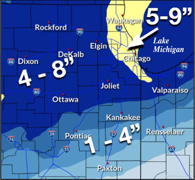
Snowfall Forecast: A swath of 4 to 9 inches of snow is expected to fall across most of northern Illinois and northwestern Indiana with highest amounts across the Chicago metro area. Gusty winds will also lead to some blowing snow, especially after sunset Saturday. #ilwx #inwx pic.twitter.com/RAapdTQ7tJ
— NWS Chicago (@NWSChicago) January 1, 2022
Once snow tapers on Sunday, temps will nosedive with wind chills Monday morning ranging from 0 to -20 F! In addition, ice will likely develop on area rivers with a threat for freeze-up ice jams on the Rock, Fox, and Kankakee rivers. #ilwx #inwx pic.twitter.com/Y8UnBkQ38M
— NWS Chicago (@NWSChicago) January 1, 2022
O’HARE FORECAST …
New Year’s Day: A chance of freezing drizzle before noon, then snow. Patchy blowing snow after 3pm. High near 33. Breezy, with a north northeast wind 15 to 20 mph, with gusts as high as 30 mph. Chance of precipitation is 100%. Total daytime ice accumulation of less than a 0.1 of an inch possible. Total daytime snow accumulation of 2 to 4 inches possible.
Tonight: Snow. The snow could be heavy at times. Patchy blowing snow before midnight. Low around 16. Blustery, with a north northeast wind 15 to 20 mph, with gusts as high as 30 mph. Chance of precipitation is 100%. New snow accumulation of 3 to 7 inches possible.
Sunday: Mostly cloudy, then gradually becoming sunny, with a temperature rising to near 19 by noon, then falling to around 14 during the remainder of the day. North northwest wind 10 to 15 mph, with gusts as high as 20 mph.
Sunday Night: Mostly clear, with a low around 4. Wind chill values as low as -5. West northwest wind 5 to 10 mph.
Monday: Sunny, with a high near 23. South southwest wind 5 to 15 mph.
Monday Night: Mostly clear, with a low around 18.
Tuesday: Partly sunny, with a high near 35.
Tuesday Night: Mostly cloudy, with a low around 16.
Wednesday: Mostly cloudy, with a high near 23.
Wednesday Night: A chance of snow. Cloudy, with a low around 12.
Thursday: A chance of snow. Mostly cloudy, with a high near 19.
Thursday Night: A chance of snow. Mostly cloudy, with a low around 1.
Friday: Mostly sunny and cold, with a high near 10.
LAKE TEMPS …
SOUTHERN LAKE MICHIGAN WATER TEMPERATURES
NATIONAL WEATHER SERVICE CHICAGO/ROMEOVILLE IL
908 AM CST Fri Dec 31 2021
LAKE MICHIGAN WATER TEMPERATURES…
CHICAGO SHORE……….44.
CHICAGO CRIB……….39.
MICHIGAN CITY……….41.
&&
M IS FOR MISSING DATA THAT IS NORMALLY AVAILABLE.
THE MICHIGAN CITY WATER TEMPERATURE SENSOR IS LOCATED AT A WATER
INTAKE ONE MILE OFFSHORE AND 60 FEET BELOW WATER SURFACE. IT IS READ EVERY DAY OF THE YEAR.
january.chicagoweatherstation.com
Chicago Weather Forecast for your MAC/PC/TABLET includes surrounding suburbs.
^^ MOBILE? USE VOICE MIC ^^
facebook …
Please ‘LIKE’ the ‘Arlington Cardinal Page. See all of The Cardinal Facebook fan pages at Arlingtoncardinal.com/about/facebook …
Help fund The Cardinal Arlingtoncardinal.com/sponsor
20240105-1435future
