
Live Blizzard 2022 coverage with Ryan Hall, Reed Timmer, Vince Waelti, and Nicholas Isabella. IMPORTANT: Slide back playback to reach earlier coverage. YouTube Tips ⓘ
Blizzard warnings are activated in Wakefield, Virginia; Caribou, Maine; Northwest Suffolk-Southwest Suffolk, New York; Northern New London-Southern New London-Northeast Suffolk-Southeast Suffolk, New York; Interior Waldo-Coastal York – Coastal Cumberland – Sagadahoc-Lincoln-Knox-Coastal Waldo-Coastal Rockingham, Maine; Boston, Massachusetts; Inland Sussex-Delaware Beaches – Western Monmouth – Eastern Monmouth – Ocean-Atlantic – Cape May – Atlantic Coastal Cape May – Coastal Atlantic – Coastal Ocean – Southeastern Burlington.
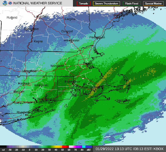
South Hampton, New London, Smithfield, Southhold, Norwich, Long Island, and Boston is likely to experience snowfall rates of 4 inches per hour which will amount to around 2+ feet of snow accumulation. Winds of 50 or 60+ MPH are reported in the Northeast.
A powerful winter storm to produce significant impacts across parts of New England and coastal Mid-Atlantic/Northeast on Saturday, January 29, 2022 with high snow accumulation along the Mid-Atlantic Coast and Northeast Coast of the United States.
According to the National Weather Service, below-average temperatures will expand across the eastern third of the country this weekend before moderating next week; Great Plains and Mississippi Valley warm up into next week.
An area of low pressure, currently off the Carolina coast, will rapidly intensify today, Saturday, January 29, 2022 as it makes its way up the eastern seaboard. Heavy snow and powerful winds will spread from the Mid-Atlantic coast to the Northeast coast throughout the day. The combination of heavy snow rates and strong winds will produce dangerous blizzard conditions across portions of the Mid-Atlantic and New England coasts, from Virginia’s Eastern Shore to eastern Maine, where Blizzard Warnings are in effect. Travel in these areas will be nearly impossible today due to whiteout conditions. Total snowfall accumulations greater than 12″ are expected along much of the Northeast coast with local maxima greater than 24″ across eastern Massachusetts including the Boston metro area. Winter Storm Watches and Warnings are also in effect from the coasts farther inland where accumulating snowfall is also likely. Strong damaging winds will lead to scattered power outages. Very cold temperatures will spread across the eastern third of the country on the backside of the departing Nor’easter. This may exacerbate an already dangerous situation for those without power/heat. The snow and wind will come to an end across northern Maine on Sunday, January 30, 2022.
Elsewhere, Freeze Watches and Warnings are in effect for much of the Florida Peninsula for tonight. Much of the state will remain mostly clear and frigid tonight with the chance for scattered to isolated falling iguanas from trees due to subfreezing temperatures that may temporarily paralyze them. The Great Plains and Mississippi Valley will warm up through the beginning of the work week.
Ryan Hall is gathering video and audio communications from chasers, including Reed Timmer on the dunes in Cape Cod. Video is sent via YouTube, Facebook, Twitter and the multiple channels are combined on Ryan Hall’s channel. Some or all of the storm chasers are communicating with Ryan Hall via Zello — an instant communication app that exchanges short audio messages similar to traditional two-way radios.
Upstream from the Nor’easter, an upper-level impulse will generate windy surface conditions across the Central Plains today. That paired with relatively dry air will lead to an elevated Fire Weather threat. An emerging low pressure system will bring rain and heavy snow to the Pacific Northwest and Northern Rockies on Sunday and continuing across the Northern Rockies into Monday. A closed upper-low may generate scattered showers and thunderstorms across southern Texas and the western Gulf coast Sunday night into Monday.
— NWS Short Range Public Discussion
^^ MOBILE? USE VOICE MIC ^^
facebook …
Please ‘LIKE’ the ‘Arlington Cardinal Page. See all of The Cardinal Facebook fan pages at Arlingtoncardinal.com/about/facebook …
Help fund The Cardinal Arlingtoncardinal.com/sponsor
20240105-1435future
THANKS FOR READING CARDINAL NEWS
