
Wet snow will develop south to north in Chicagoland, breaking a record 287 days since the last measurable snow fall. Chicago broke the record for the latest snow measurable at 0.1 inch or more. This season will likely not break the record for the latest snowfall measuring 1 inch or more, which is January 25, 2013.
UPDATE …
WINTER WEATHER ADVISORY; But Snow Forecast Diminished for Arlington Heights
********************
SNOW STATS
MEASURABLE (0.1 Inches or More)
Normal First Date: November 18
Normal Last Date: April 2
Earliest First: October 12, 2006
Earliest Last: February 28, 1994
Latest First: December 20, 2012
Latest Last: May 11, 1966
MEASURABLE (1 Inch or More)
Normal First Date: December 7
Normal Last Date: March 20
Earliest First: October 19, 1989
Earliest Last: January 18, 1927
Latest First: January 25, 2013
Latest Last: May 3-4, 1907
********************
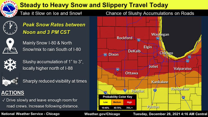
The factors are brewing this morning for the first real accumulating snow for much of northern Illinois and northwestern Indiana later this morning and into the afternoon Tuesday, December 28, 2021. While total snow amounts will generally be in the 1 to 4 inch range, these amounts will fall in about a 2 to 5 hour period today, making for some periods of very low visibilities in moderate to heavy snow and associated travel impacts. Peak snow rates will occur in most areas between 12:00 p.m. and 3:00 p.m. Roads are likely to go from wet to slush to wet snow.
Since the highest accumulation of snow looks to generally be along and north of I-80, the NWS Chicago office opted to add Porter county Indiana into the winter weather advisory. Over the past 48 hours the weather outlook has trended toward larger snow accumulations over a great area in northern Illinois.
Precipitation is expected to develop from south to north across the area through the morning. While, there is a good amount of dry air in the low levels currently, the thinking continues to be that top down saturation will occur rapidly this morning as the influx of deeper moisture quickly shifts into the area. The dry air will set us up for some good evaporative cooling initially as precipitation begins to descend through this dry layer. This will do two things to support some heavy snow today.
First it will cool the column enough to support the precipitation remaining mainly snow as it onsets this morning.
Second, it will aid in strengthening the baroclinic zone overhead, further setting the stage for a strengthening band of low-to-mid level frontogenesis ahead of the approaching warm, and beneath the favorable upper level dynamics associated with the right entrance region of the jet.
Baroclinic Zone
A region in which a temperature gradient exists on a constant pressure surface. Baroclinic zones are favored areas for strengthening and weakening systems; barotropic systems, on the other hand, do not exhibit significant changes in intensity. Also, wind shear is characteristic of a baroclinic zone.
According to the National Weather Service, the window for snowfall will be rather short (2 to 5 hours), especially for areas south of I-80, just south of the current Winter Weather Advisory. While this short duration does not bode well for a lot of accumulation, the fact the snow is likely to fall at a moderate to heavy rate could support a couple of inches of wet snow. The best chance for 2 to 3 inches (locally higher) of snow is north of I-80, and inland from the lake in the current Winter Weather Advisory area. Temperatures should remain locked right around the freezing mark in the lower levels of the atmosphere during the snow, which will support large wet aggregate type snowflakes. Expect slushy accumulations on the warmer paved surfaces, according to the National Weather Service office in Chicago. There might be a significant delay for the beginning of accumulation of snow on streets and sidewalks, compared to grass and lawns.
Conditions should begin to improve south of I-80 by, or shortly after midday, as warmer air leads to a change over to rain or drizzle. This warmer air will work northward into far northern Illinois during the afternoon. By 3 pm this afternoon areas south of I-88 will see a transition over to light rain and drizzle. Total snow amounts of 2 to 3 inches (locally higher) are likely north of I-80/I-88 and inland from the lake, with less than an inch favored far south and right along the lakeshore.
Snow should end in Arlington Heights by about 3:00 p.m. with flurries continuing until 6:00 p.m. at the latest.
— NWS Chicago with CARDINAL NEWS edits
********************
SNOW ACCUMULATION FORECAST
Snow Periods with Accumulation
Arlington Heights
2.1″ from 10AM to 4PM
Antioch
2.8″ from 11AM to 4PM
Aurora
2.2″ from 10A to 3PM
Des Plaines
1.9″ from 10A to 3PM
DeKalb
2.6″ from 9AM to 3PM
Dixon
2.6″ from 9AM to 3PM
Elgin
2.9″ from 10AM to 4PM
Fox Lake
2.9′ from 10AM to 4PM
Gurnee
1.6″ from 10AM to 4PM
Harvard
2.9″ from 10AM to 5PM
Joliet
1.8″ from 9A to 2PM
Kenosha, Wisconsin
0.9″ from 12PM to 5PM
Lake Forest
1.1″ from 10AM to 4PM
Lake Geneva
3.3″ from 10AM to 7PM
Lake Villa
2.6″ from 10AM to 4PM
Lake Zurich
2.8″ from 10AM to 4PM
Long Grove
2.6″ from 10AM to 4PM
McHenry
2.8″ from 10AM to 4PM
Naperville
2.2″ from 10AM to 3PM
Oak Park
1.7″ from 10AM to 3PM
Orland Park
2.1″ from 9AM to 3PM
Schaumburg
2.7″ from 10AM to 3PM
Vernon Hills
2.5″ from 10A to 4PM
Waukegan
1.1″ from 10AM to 4PM
Wheaton
2.4″ from 9AM to 3PM
Woodstock
2.9″ from 10AM to 4PM
*Time period excludes period of snow flurries before and after main snow.
********************
Weather Radar in northeast Illinois was clear at 3:30 a.m., but bands of precipitation that are mostly rain developing and moving northeast. A large area of rain precipitation exists in central Illinois and western and northwestern Illinois — all moving northeast. Initially rain is changing over to snow in south central Wisconsin.
See also Arlingtoncardinal.com/clouds
URGENT – WINTER WEATHER MESSAGE National Weather Service Chicago IL 220 AM CST Tue Dec 28 2021
ILZ003>006-008-010>013-103-104-281630- /O.CON.KLOT.WW.Y.0013.211228T1500Z-211229T0000Z/ Winnebago-Boone-McHenry-Lake IL-Ogle-Lee-De Kalb-Kane-DuPage- Northern Cook-Central Cook- Including the cities of Rockford, Belvidere, Crystal Lake, Algonquin, McHenry, Woodstock, Waukegan, Buffalo Grove, Mundelein, Gurnee, Rochelle, Oregon, Byron, Dixon, DeKalb, Sycamore, Aurora, Elgin, Naperville, Wheaton, Downers Grove, Lombard, Carol Stream, Evanston, Des Plaines, Schaumburg, Palatine, Northbrook, Chicago, Cicero, Oak Lawn, Oak Park, and La Grange 220 AM CST Tue Dec 28 2021
…WINTER WEATHER ADVISORY REMAINS IN EFFECT FROM 9 AM THIS MORNING TO 6 PM CST THIS EVENING…
* WHAT…Slippery travel conditions due to steady snow expected.
* WHERE…Portions of north central and northeast Illinois.
* WHEN…From 9 AM to 6 PM CST Tuesday.
* IMPACTS…Plan on slippery road conditions.
PRECAUTIONARY/PREPAREDNESS ACTIONS…
Slow down and use caution while traveling.
The latest road conditions for Illinois can be obtained on the internet at www.gettingaroundillinois.com.
PRECAUTIONARY/PREPAREDNESS ACTIONS…
Slow down and use caution while traveling.
8:15 AM CST Update: The radar looks menacing but snow is not reaching the ground yet across northern Illinois and northwestern Indiana. This will change toward 10-11 am with the heaviest snow expected between noon and 3 pm. #ilwx #inwx pic.twitter.com/cTcgcaLYty
— NWS Chicago (@NWSChicago) December 28, 2021
Snow develops south to north this AM. Heaviest snow falls this AM south of I-80, and during the 11 am to 3pm timeframe north. Wet snow amounts of 1 to 3” north of I-80, with amounts close to 4” PSBL near WI state line. Snow changes to drizzle mid to late this PM. #ilwx #inwx pic.twitter.com/bI8eaFF3TE
— NWS Chicago (@NWSChicago) December 28, 2021
The area will see its first accumulating snow today. Another quick hitting disturbance will produce another period of wintry weather Wed night. Then, attention turns to the New Year's weekend when the area could see a winter storm move across the region. Stay tuned! #ilwx #inwx pic.twitter.com/oklrCBy5Gq
— NWS Chicago (@NWSChicago) December 28, 2021
O’HARE FORECAST …
Today: Snow before 4pm, then drizzle, possibly mixed with snow. The snow could be heavy at times. Areas of fog after 4pm. High near 37. East wind 5 to 10 mph, with gusts as high as 25 mph. Chance of precipitation is 100%. Total daytime snow accumulation of 1 to 3 inches possible.
Tonight: Drizzle likely, possibly mixed with snow before 7pm, then a chance of drizzle between 7pm and 1am. Areas of fog. Otherwise, cloudy, with a steady temperature around 36. East wind 5 to 10 mph becoming west after midnight. Winds could gust as high as 15 mph. Chance of precipitation is 20%.
Wednesday: A slight chance of rain and snow between 4pm and 5pm, then a slight chance of snow after 5pm. Patchy fog before 7am. Otherwise, mostly cloudy, with a high near 35. West wind around 5 mph becoming north in the afternoon. Winds could gust as high as 10 mph. Chance of precipitation is 20%.
Wednesday Night: Snow likely, mainly before 1am. Cloudy, with a low around 29. North northeast wind 5 to 10 mph. Chance of precipitation is 70%. New snow accumulation of less than one inch possible.
Thursday: Mostly cloudy, with a high near 36. North wind 5 to 10 mph becoming southwest in the afternoon.
Thursday Night: Mostly cloudy, with a low around 29.
Friday: Partly sunny, with a high near 39.
Friday Night: Rain and snow likely after 7pm, becoming all snow after 2am. Cloudy, with a low around 30.
New Year’s Day: Snow likely before 2pm, then rain and snow likely between 2pm and 4pm, then snow likely after 4pm. Cloudy, with a high near 35.
Saturday Night: Snow likely, mainly before 7pm. Mostly cloudy, with a low around 15.
Sunday: A slight chance of snow. Mostly sunny, with a high near 23.
Sunday Night: Mostly clear, with a low around 11.
Monday: Sunny, with a high near 29.
LAKE TEMPS …
SOUTHERN LAKE MICHIGAN WATER TEMPERATURES
NATIONAL WEATHER SERVICE CHICAGO/ROMEOVILLE IL
905 AM CST Sun Dec 26 2021
LAKE MICHIGAN WATER TEMPERATURES…
CHICAGO SHORE……….45.
CHICAGO CRIB……….43.
MICHIGAN CITY……….42.
&&
M IS FOR MISSING DATA THAT IS NORMALLY AVAILABLE.
THE MICHIGAN CITY WATER TEMPERATURE SENSOR IS LOCATED AT A WATER
INTAKE ONE MILE OFFSHORE AND 60 FEET BELOW WATER SURFACE. IT IS READ EVERY DAY OF THE YEAR.
december.chicagoweatherstation.com
Chicago Weather Forecast for your MAC/PC/TABLET includes surrounding suburbs.
^^ MOBILE? USE VOICE MIC ^^
facebook …
Please ‘LIKE’ the ‘Arlington Cardinal Page. See all of The Cardinal Facebook fan pages at Arlingtoncardinal.com/about/facebook …
Help fund The Cardinal Arlingtoncardinal.com/sponsor
20240105-1435future
