
Dangerous Lake Michigan Swimming Conditions
The forecast calls for decreasing clouds this afternoon and falling temperatures to comfortable levels by 8:00 p.m. Thursday night. Following a high of 86°F around 11:00 a.m. and a Heat Index in the mid-90s, Arlington Heights and surrounding communities will see temperatures of 76°F by 8:00 p.m. and 71°F by midnight.
The line of thunderstorms forecast for last night moved into northeast Illinois from northwest to southeast early Thursday morning. At 233 a.m. CDT, severe thunderstorms were located along a line extending from Lake Bluff to near Hampshire to near Kirkland, moving southeast at 50 mph. The storms started diminishing in intensity after passing Madison, Wisconsin into Lake County and McHenry County in Illinois. A Severe Thunderstorm Warning was activated for Madison at 12:45 a.m. A Severe Thunderstorm Warning was activated for Lake County and McHenry County around 1:56 a.m. and for Cook, De Kalb, DuPage, and Kane counties at 2:34 a.m. The storms had significantly diminished by the time they reached Cook County.
There were multiple reports of wind damage in McHenry County and Lake County by 2:30 a.m. Thursday. There was thunderstorm wind damage reported in Crystal Lake, Hebron, McHenry, Wonder Lake in McHenry County; and Antioch, Lake Barrington, Lake Villa, Mundelein, Winthrop Harbor and Zion in Lake County.
Woodstock Fire Rescue District responded around sunrise Thursday, July 29, 2021 to extinguish a fire in a wood enclosure surrounding an incinerator. A lightning strike is suspected to have caused the fire.
In Cook County a tree fell on a house and power lines nearby on Wildwood Court in Streamwood, a large tree fell on Spring Valley Court, a large tree fell and blocked Wolf Road in Mount Prospect, and several tree limbs were reported down in Riverside.
In Kane County a large tree limb was down in Batavia at Millview Drive and Town Avenue, several trees were reported down in East Dundee at Route 25 and Sunset Park Drive, wires on trees with fires were reported east of Maple Park at Route 38 and Schrader Road, and a large tree was down in the roadway in Elgin at Liberty Street and Sherman Avenue.
Arlington Heights firefighters were only dispatched to one storm-related call overnight — an arcing power line ignited a utility pole in the block of 1800 North Chestnut Avenue just north of Hasbrook Park.
REPORTED WIND GUSTS
Chicago Executive Airport 55 MPH
McHenry County College 60 MPH.
Midway International Airport 60 MPH.
DuPage Airport 64 MPH.
The apex of the bow echo which was forecast Thursday afternoon to track northeast of Arlington Heights and surrounding communities, actually tracked west of Arlington Heights. The line of thunderstorms also weakened as the line crossed the Illinois – Wisconsin state line
ComEd reported that 534 customers were without power near Ela Road and Cuba Road, and there were several other outages affecting groups of customers in the range of 60 to 200 customers without power in the northwest suburbs.
Weather Radar) shows OR Weather Radar in northeast Illinois is clear.
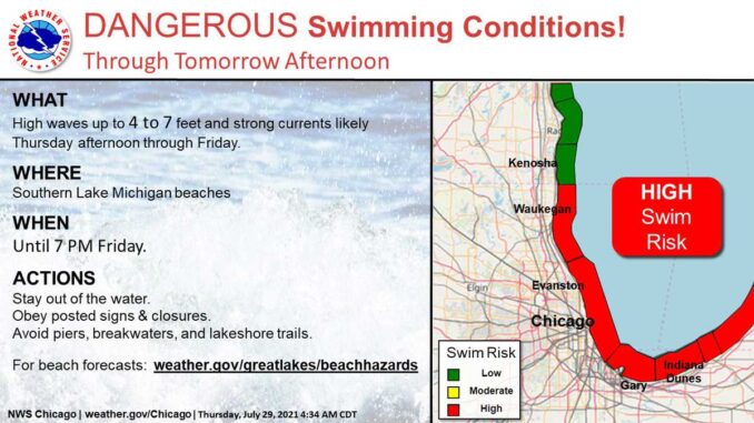
[5:08 AM 7/29] Breezy north to northeast winds behind a cold front will deliver increasing wave action to the southern Lake Michigan beaches where dangerous swimming conditions are expected through tomorrow afternoon. Stay dry when the waves are high! #ILwx #INwx pic.twitter.com/z2sSf7qlkm
— NWS Chicago (@NWSChicago) July 29, 2021
[5:03 AM 7/29] Lingering early-AM showers & storms will clear the area through mid morning. Hot & humid conditions continue south of I-80 where heat indices may near 105 this afternoon along with a potential for a few strong to severe storms. #ILwx #INwx pic.twitter.com/0Yu7FBfaq5
— NWS Chicago (@NWSChicago) July 29, 2021
This Afternoon: Partly sunny, with a high near 87. Northeast wind around 15 mph, with gusts as high as 25 mph.
Tonight: Mostly clear, with a low around 65. North northeast wind 10 to 15 mph, with gusts as high as 25 mph.
Friday: Mostly sunny, with a high near 78. North northeast wind around 10 mph, with gusts as high as 20 mph.
Friday Night: Partly cloudy, with a low around 62. East northeast wind 5 to 10 mph becoming west southwest after midnight.
Saturday: A 20 percent chance of showers and thunderstorms after 1pm. Mostly sunny, with a high near 82. West southwest wind 5 to 10 mph.
Saturday Night: A 20 percent chance of showers and thunderstorms before 1am. Partly cloudy, with a low around 65.
Sunday: Sunny, with a high near 78.
Sunday Night: Mostly clear, with a low around 61.
Monday: Sunny, with a high near 78.
Monday Night: Partly cloudy, with a low around 62.
Tuesday: Mostly sunny, with a high near 81.
Tuesday Night: Mostly clear, with a low around 63.
Wednesday: Mostly sunny, with a high near 82.
LAKE TEMPS …
SOUTHERN LAKE MICHIGAN WATER TEMPERATURES NATIONAL WEATHER SERVICE CHICAGO/ROMEOVILLE IL 907 AM CDT Thu Jul 29 2021
LAKE MICHIGAN WATER TEMPERATURES…
CHICAGO SHORE……….67.
CHICAGO CRIB……….80.
WILMETTE BUOY……….73.
WAUKEGAN BUOY……….69.
WINTHROP HARBOR BUOY……….69.
MICHIGAN CITY……….73.
MICHIGAN CITY BUOY……….M.
&&
M IS FOR MISSING DATA THAT IS NORMALLY AVAILABLE.
THE MICHIGAN CITY WATER TEMPERATURE SENSOR IS LOCATED AT A WATER INTAKE ONE MILE OFFSHORE AND 60 FEET BELOW WATER SURFACE. IT IS READ EVERY DAY OF THE YEAR.
july.chicagoweatherstation.com
Chicago Weather Forecast for your MAC/PC/TABLET includes surrounding suburbs.
^^ MOBILE? USE VOICE MIC ^^
facebook …
Please ‘LIKE’ the ‘Arlington Cardinal Page. See all of The Cardinal Facebook fan pages at Arlingtoncardinal.com/about/facebook …
Help fund The Cardinal Arlingtoncardinal.com/sponsor
20240105-1435future
