
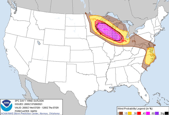
The greatest chance for severe thunderstorms in Arlington Heights and surrounding suburbs are likely from 12:30 a.m. to 3:30 a.m. Thursday, July 29, 2021. Peak winds are likely from 2:30 a.m. to 3:30 a.m. Wind gusts in thunderstorms of 60-70 MPH are possible, but the apex of the bow echo with wind gusts possibly in excess of 75 MPH are expected with uncertainty to pass northeast of Arlington Heights and surrounding suburbs. Storms will be moving from northwest to southeast.
Unstable air overnight ahead of a cold front “cool front” will bring the potential for a complex of severe thunderstorms with damaging winds and possibly a tornado. The greatest chance for severe weather is in McHenry County, Lake County, north and northwest Cook County with a greater chance Wednesday night before midnight Thursday across Wisconsin from northwest Wisconsin to central Wisconsin to southeast and most of east Wisconsin. There is a chance of a tornado in northern Illinois, but the greater chance exists in most of Wisconsin.
There is a good chance of damaging thunderstorm winds overnight in McHenry County, Lake County and extreme northern Cook County. High end wind gusts are also possible in southern Lake Michigan along with water a meteotsunami (high waves driven by air-pressure disturbances often associated with fast-moving weather events, such as severe thunderstorms, squalls, and other storm fronts) or seiche (high waves usually caused by high winds) early Thursday morning. Meteosunami and seiche can happen simultaneously.
One-half inch to an inch of rain is possible in Arlington Heights between midnight and 7:00 a.m. However, storms may build behind the forward flank of thunderstorms which would increase the risk of heavier rains and flash flooding in the northwest suburbs.
Following a high of 85°F from 11:00 a.m. to noon Thursday, cooler temperatures with the associated cold front is forecast to arrive between 12:30 p.m. and 4:00 p.m. Thursday with air temperature at 78°F by 6:00 p.m. and 74°F by 9:00 p.m.
Weather Radar in northeast Illinois was clear at 7:50 p.m. The nearest radar echos at 7:50 p.m. were forming along a line in northern Wisconsin from Green Bay to Wasau to Rice Lake and south of Hayward.
[2:52 PM 7/28] We continue to monitor a potential for severe weather tonight. A line of storms capable of downing trees and powerlines exists, but uncertainty in where the core of strongest winds tracks remains! Main time window ~midnight-5am. #ILwx #INwx pic.twitter.com/k5UgGTJieY
— NWS Chicago (@NWSChicago) July 28, 2021
Here is a *rough* timeline of storm chances tonight. Storm chances will peak in the 1-4 AM window, along with the severe potential. https://t.co/VXboz3xgWn pic.twitter.com/GBatrFJGz5
— NWS Chicago (@NWSChicago) July 28, 2021
A cold front will shift southward Thursday afternoon that will cause high wave action and strong currents through the day on Friday. If you are planning to go to a beach on Thursday or Friday, remain out of the water. #ilwx #inwx pic.twitter.com/KqCOwMnhAZ
— NWS Chicago (@NWSChicago) July 28, 2021
O’HARE FORECAST …
Tonight: Showers and thunderstorms, mainly before 5am. Low around 76. Breezy, with a south southwest wind 10 to 20 mph becoming north northwest after midnight. Winds could gust as high as 25 mph. Chance of precipitation is 80%. New rainfall amounts between a half and three quarters of an inch possible.
Thursday: A 30 percent chance of showers and thunderstorms, mainly before 7am. Partly sunny, with a high near 85. West wind 10 to 15 mph becoming north northeast in the afternoon. Winds could gust as high as 25 mph.
Thursday Night: Mostly clear, with a low around 65. North northeast wind 10 to 15 mph, with gusts as high as 20 mph.
Friday: Mostly sunny, with a high near 77. Northeast wind around 10 mph.
Friday Night: Mostly cloudy, with a low around 63. East northeast wind around 5 mph becoming southwest after midnight.
Saturday: A 30 percent chance of showers and thunderstorms, mainly after 1pm. Mostly sunny, with a high near 82.
Saturday Night: A 30 percent chance of showers and thunderstorms before 1am. Partly cloudy, with a low around 65.
Sunday: Sunny, with a high near 77.
Sunday Night: Mostly clear, with a low around 61.
Monday: Sunny, with a high near 77.
Monday Night: Mostly clear, with a low around 61.
Tuesday: Mostly sunny, with a high near 80.
Tuesday Night: Mostly clear, with a low around 64.
Wednesday: Mostly sunny, with a high near 83.
LAKE TEMPS …
SOUTHERN LAKE MICHIGAN WATER TEMPERATURES
NATIONAL WEATHER SERVICE CHICAGO/ROMEOVILLE IL
905 AM CDT Wed Jul 28 2021
LAKE MICHIGAN WATER TEMPERATURES…
CHICAGO SHORE……….67.
CHICAGO CRIB……….72.
WILMETTE BUOY……….74.
WAUKEGAN BUOY……….74.
WINTHROP HARBOR BUOY……….71.
MICHIGAN CITY……….71.
MICHIGAN CITY BUOY……….M.
&&
M IS FOR MISSING DATA THAT IS NORMALLY AVAILABLE.
THE MICHIGAN CITY WATER TEMPERATURE SENSOR IS LOCATED AT A WATER
INTAKE ONE MILE OFFSHORE AND 60 FEET BELOW WATER SURFACE. IT IS READ
EVERY DAY OF THE YEAR.
july.chicagoweatherstation.com
Chicago Weather Forecast for your MAC/PC/TABLET includes surrounding suburbs.
^^ MOBILE? USE VOICE MIC ^^
facebook …
Please ‘LIKE’ the ‘Arlington Cardinal Page. See all of The Cardinal Facebook fan pages at Arlingtoncardinal.com/about/facebook …
Help fund The Cardinal Arlingtoncardinal.com/sponsor
20240105-1435future
