
CHICAGOLAND DETAILS …
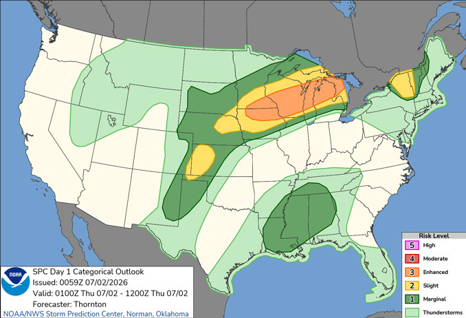
Radar is clear in northern Illinois. There is an outflow-reinforced frontal boundary stretching from central Lower Michigan through central Wisconsin and through northwestern Iowa, also with radar evidence and associated with a Level 3/5 Risk of severe thunderstorms. The frontal boundary continues to serve as a route for episodic clusters of showers and thunderstorms in the central and upper Great Lakes region, which included a supercell that produced a 3-inch hailstone near Fond du Lac, Wisconsin Wednesday afternoon, July 1, 2026.
Areas in Fond du Lac reported golf-ball-sized hail on Wednesday as storms passed through.
One viewer sent us this paw-sitively crazy view.
📸: Amanda Guell pic.twitter.com/cp6eIKdGHC
— Spectrum News 1 Wisconsin (@SpectrumNews1WI) July 1, 2026
Hot and humid conditions will continue through the Independence Day weekend with daily peak heat index values near 100 degrees.
Waves of thunderstorms are expected Thursday evening through the weekend, but with many dry hours.
See also: LIVE STREAMS: Arlingtoncardinal.com/StormChasers
Temperature Outlook …
R 75 95 | F 75 90 | SA 73 87 | SU 70 86
O’HARE FORECAST …
Extreme Heat Warning until July 3, 12:00 AM CDT
Wednesday Night: Mostly clear, with a low around 75. West southwest wind 5 to 10 mph, with gusts as high as 25 mph.
Thursday: A 20 percent chance of showers and thunderstorms before 10am. Sunny and hot, with a high near 95. Heat index values as high as 102. North northeast wind 10 to 15 mph becoming south southwest in the morning.
Thursday Night: A 50 percent chance of showers and thunderstorms, mainly before 4am. Partly cloudy, with a low around 75. Southwest wind 5 to 10 mph, with gusts as high as 20 mph.
Friday: Showers and thunderstorms likely, mainly after 1pm. Partly sunny, with a high near 90. Heat index values as high as 99. Southwest wind 5 to 10 mph, with gusts as high as 15 mph. Chance of precipitation is 70%.
Friday Night: Showers and thunderstorms likely, mainly after 1am. Mostly cloudy, with a low around 73. South southwest wind 5 to 10 mph. Chance of precipitation is 70%.
Independence Day (Saturday): Showers and thunderstorms likely, mainly after 1pm. Partly sunny, with a high near 87. Chance of precipitation is 70%.
Saturday Night: Showers likely and possibly a thunderstorm before 1am, then a chance of showers and thunderstorms after 1am. Mostly cloudy, with a low around 70. Chance of precipitation is 60%.
Sunday: Partly sunny, with a high near 86.
Sunday Night: Mostly cloudy, with a low around 68.
Monday: Partly sunny, with a high near 85.
Monday Night: Partly cloudy, with a low around 68.
Tuesday: Mostly sunny, with a high near 88.
Tuesday Night: Partly cloudy, with a low around 70.
RADAR • Clouds • Temps • NWS CHGO • UV

PHOENIX FORECAST …
Air Quality Alert … OZONE HIGH POLLUTION ADVISORY FOR MARICOPA COUNTY INCLUDING THE PHOENIX METRO AREA THROUGH THURSDAY…
Overnight: Clear, with a low around 75. Calm wind.
Thursday: Sunny, with a high near 102. Calm wind becoming southeast around 5 mph.
Thursday Night: Mostly clear, with a low around 77. West northwest wind around 5 mph becoming calm.
Friday: Mostly sunny, with a high near 106. Calm wind becoming west around 5 mph in the afternoon.
Friday Night: Partly cloudy, with a low around 81. West wind around 5 mph becoming calm.
Independence Day (Saturday): Mostly sunny, with a high near 107. Calm wind becoming west southwest around 5 mph in the afternoon.
Saturday Night: Partly cloudy, with a low around 85. West wind around 5 mph becoming calm in the evening.
Sunday: Mostly sunny, with a high near 108. Calm wind becoming west around 5 mph in the afternoon.
Sunday Night: Partly cloudy, with a low around 85. West wind around 5 mph becoming calm in the evening.
Monday: Sunny and hot, with a high near 110. Calm wind becoming west around 5 mph in the afternoon.
Monday Night: Mostly clear, with a low around 87. West wind around 5 mph becoming calm after midnight.
Tuesday: Sunny and hot, with a high near 112. Light and variable wind becoming west 5 to 10 mph in the afternoon.
Tuesday Night: Mostly clear, with a low around 88. West wind around 5 mph becoming calm after midnight.
RADAR • Clouds • Temps • NWS Phoenix • UV

MIAMI FORECAST …
Overnight: A 30 percent chance of showers and thunderstorms, mainly between 4am and 5am. Partly cloudy, with a low around 79. Calm wind.
Thursday: Showers and thunderstorms likely, mainly after 2pm. Partly sunny, with a high near 90. Heat index values as high as 105. Calm wind becoming southeast 5 to 8 mph in the afternoon. Chance of precipitation is 60%. New rainfall amounts between a quarter and half of an inch possible.
Thursday Night: Showers and thunderstorms likely, mainly before 9pm. Partly cloudy, with a low around 79. Light and variable wind. Chance of precipitation is 60%. New precipitation amounts between a tenth and quarter of an inch, except higher amounts possible in thunderstorms.
Friday: A 30 percent chance of showers and thunderstorms, mainly after 4pm. Mostly sunny, with a high near 91. Heat index values as high as 106. Calm wind becoming southeast 5 to 8 mph in the afternoon.
Friday Night: A 30 percent chance of showers and thunderstorms, mainly after 2am. Partly cloudy, with a low around 80. Southeast wind 3 to 5 mph.
Independence Day (Saturday): Showers and thunderstorms likely, mainly between 2pm and 5pm, then showers likely and possibly a thunderstorm after 5pm. Mostly sunny, with a high near 91. Calm wind becoming southeast 5 to 8 mph in the afternoon. Chance of precipitation is 60%.
Saturday Night: Showers likely and possibly a thunderstorm before 8pm, then a chance of showers and thunderstorms after 2am. Partly cloudy, with a low around 81. Southeast wind around 6 mph. Chance of precipitation is 60%.
Sunday: A 50 percent chance of showers and thunderstorms. Mostly sunny, with a high near 90. Light southeast wind increasing to 5 to 9 mph in the morning.
Sunday Night: A 40 percent chance of showers and thunderstorms after 2am. Partly cloudy, with a low around 81. Southeast wind around 7 mph.
Monday: A 40 percent chance of showers and thunderstorms. Mostly sunny, with a high near 91.
Monday Night: A 20 percent chance of showers and thunderstorms. Partly cloudy, with a low around 81.
Tuesday: A 40 percent chance of showers and thunderstorms. Sunny, with a high near 91.
Tuesday Night: A 30 percent chance of showers and thunderstorms. Mostly clear, with a low around 81.
RADAR • Clouds • Temps • NWS Miami • UV

LAX FORECAST …
Overnight: Patchy fog. Otherwise, cloudy, with a low around 59. Southwest wind around 5 mph.
Thursday: Patchy fog before 11am. Otherwise, cloudy, then gradually becoming mostly sunny, with a high near 72. West wind 5 to 15 mph.
Thursday Night: Patchy fog after 11pm. Otherwise, increasing clouds, with a low around 60. West southwest wind 10 to 15 mph becoming light southwest after midnight.
Friday: Patchy fog before 11am. Otherwise, cloudy through mid morning, then gradual clearing, with a high near 71. South wind 5 to 10 mph becoming west 10 to 15 mph in the afternoon. Winds could gust as high as 20 mph.
Friday Night: Patchy fog after 11pm. Otherwise, mostly cloudy, with a low around 61. West southwest wind 10 to 15 mph decreasing to 5 to 10 mph in the evening. Winds could gust as high as 20 mph.
Independence Day (Saturday): Patchy fog before 11am. Otherwise, partly sunny, with a high near 72.
Saturday Night: Patchy fog after 11pm. Otherwise, cloudy, with a low around 62.
Sunday: Patchy fog before 11am. Otherwise, mostly sunny, with a high near 71.
Sunday Night: Partly cloudy, with a low around 62.
Monday: Partly sunny, with a high near 72.
Monday Night: Partly cloudy, with a low around 62.
Tuesday: Mostly sunny, with a high near 73.
Tuesday Night: Partly cloudy, with a low around 63.
RADAR • Clouds • Temps • NWS Los Angeles • UV

WASH DC FORECAST …
Extreme Heat Warning in effect from July 2, 10:00 AM EDT until July 2, 08:00 PM EDT
Extreme Heat Warning in effect from July 3, 10:00 AM EDT until July 3, 08:00 PM EDT
Overnight: Mostly clear, with a low around 78. Calm wind.
Thursday: Sunny and hot, with a high near 102. Heat index values as high as 110. Light and variable wind.
Thursday Night: Clear, with a low around 81. Southwest wind around 5 mph becoming calm in the evening.
Friday: A slight chance of showers and thunderstorms after 2pm. Sunny and hot, with a high near 104. Heat index values as high as 112. Calm wind becoming west around 6 mph in the afternoon. Chance of precipitation is 20%.
Friday Night: Mostly clear, with a low around 81. Light northwest wind.
Independence Day (Saturday): A chance of showers and thunderstorms after 2pm. Mostly sunny and hot, with a high near 101. Chance of precipitation is 50%.
Saturday Night: A chance of showers and thunderstorms before 2am. Mostly cloudy, with a low around 77. Chance of precipitation is 50%.
Sunday: Showers likely and possibly a thunderstorm after 2pm. Partly sunny and hot, with a high near 97. Chance of precipitation is 60%.
Sunday Night: Showers likely and possibly a thunderstorm before 2am, then a slight chance of showers. Mostly cloudy, with a low around 73. Chance of precipitation is 60%.
Monday: A chance of showers, then showers likely and possibly a thunderstorm after 2pm. Partly sunny, with a high near 91. Chance of precipitation is 70%.
Monday Night: Showers and thunderstorms likely. Mostly cloudy, with a low around 71. Chance of precipitation is 60%.
Tuesday: A chance of showers and thunderstorms. Partly sunny, with a high near 89. Chance of precipitation is 30%.
Tuesday Night: A chance of showers and thunderstorms. Partly cloudy, with a low around 70. Chance of precipitation is 30%.
Baltimore/Washington DC Forecast
RADAR • Clouds • Temps • NWS Baltimore/Washington • UV
O’Hare Weather Forecast Compared to Phoenix, Miami, LA, Wash DC WED JUL 01, 2026 11:53 PM SOURCE: National Weather Service local offices.
