
CHICAGOLAND DETAILS …
Radar is clear in northern Illinois at 11:19 p.m.
Extreme Heat Warning until Friday, July 3, 12:00 AM CDT.
Overnight Monday/Tuesday was a warm low of 79, and Tuesday’s high was about 93.
Dangerous heat wave continues and will begin to dissipate Friday at 12:00 a.m., with daytimes highs in the low to mid 90s and peak afternoon heat indices of 100 to 105 degrees (locally higher).
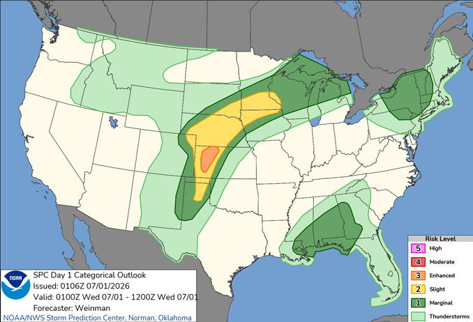
While not a complete wash out, scattered thunderstorm chances increase late Thursday, with a couple of waves of showers and thunderstorms expected Friday into the 4th of July weekend. Some storms may be severe and produce heavy rainfall.
See also: LIVE STREAMS: Arlingtoncardinal.com/StormChasers
Temperature Outlook …
W 78 96 | R 80 96 | F 77 93 | SA 73 85
O’HARE FORECAST …
Extreme Heat Warning until Friday, July 3, 12:00 AM CDT.
Tuesday Night: Mostly clear, with a low around 78. Southwest wind around 10 mph, with gusts as high as 20 mph.
Wednesday: Sunny and hot, with a high near 96. Heat index values as high as 103. South southwest wind 10 to 15 mph, with gusts as high as 25 mph.
Wednesday Night: Mostly clear, with a low around 80. South southwest wind 10 to 15 mph, with gusts as high as 25 mph.
Thursday: Sunny and hot, with a high near 96. Heat index values as high as 102. Southwest wind 10 to 15 mph, with gusts as high as 25 mph.
Thursday Night: A chance of showers and thunderstorms before 4am, then a slight chance of showers. Partly cloudy, with a low around 77. Southwest wind 5 to 15 mph, with gusts as high as 20 mph. Chance of precipitation is 30%.
Friday: A chance of showers before 10am, then a chance of showers and thunderstorms between 10am and 1pm, then showers likely and possibly a thunderstorm after 1pm. Mostly sunny, with a high near 93. Chance of precipitation is 60%.
Friday Night: A chance of showers and thunderstorms, then showers likely and possibly a thunderstorm after 1am. Mostly cloudy, with a low around 73. Chance of precipitation is 60%.
Independence Day (Saturday): A chance of showers and thunderstorms after 1pm. Partly sunny, with a high near 85.
Saturday Night: Showers likely and possibly a thunderstorm before 1am, then a chance of showers. Mostly cloudy, with a low around 70.
Sunday: A chance of showers and thunderstorms after 1pm. Partly sunny, with a high near 83.
Sunday Night: Mostly cloudy, with a low around 68.
Monday: Mostly sunny, with a high near 83.
Monday Night: Partly cloudy, with a low around 68.
RADAR • Clouds • Temps • NWS CHGO • UV

PHOENIX FORECAST …
Air Quality Alert … OZONE HIGH POLLUTION ADVISORY FOR MARICOPA COUNTY INCLUDING THE PHOENIX METRO AREA THROUGH WEDNESDAY, July 1, 2026
Tuesday Night: Clear, with a low around 75. Southwest wind around 5 mph becoming calm in the evening.
Wednesday: Sunny, with a high near 101. Calm wind becoming south southeast around 5 mph.
Wednesday Night: Clear, with a low around 75. West wind around 5 mph becoming calm.
Thursday: Sunny, with a high near 103. Calm wind becoming south southwest around 5 mph in the afternoon.
Thursday Night: Mostly clear, with a low around 78. West wind around 5 mph becoming calm.
Friday: Mostly sunny, with a high near 105. Calm wind becoming west southwest around 5 mph in the afternoon.
Friday Night: Partly cloudy, with a low around 82. West wind around 5 mph becoming calm in the evening.
Independence Day (Saturday): Mostly sunny, with a high near 106. Calm wind becoming west southwest around 5 mph in the afternoon.
Saturday Night: Partly cloudy, with a low around 84. West wind around 5 mph becoming calm in the evening.
Sunday: Mostly sunny, with a high near 109. Calm wind becoming west around 5 mph in the afternoon.
Sunday Night: Mostly clear, with a low around 85. West wind around 5 mph becoming calm after midnight.
Monday: Sunny and hot, with a high near 110. Calm wind becoming west around 5 mph in the afternoon.
Monday Night: Mostly clear, with a low around 86. West wind around 5 mph becoming calm after midnight.
RADAR • Clouds • Temps • NWS Phoenix • UV

MIAMI FORECAST …
Overnight Tuesday/Wednesday: Partly cloudy, with a low around 80. Calm wind.
Wednesday: Showers and thunderstorms likely, mainly after 3pm. Mostly sunny, with a high near 91. Heat index values as high as 105. Calm wind becoming east 5 to 8 mph in the afternoon. Chance of precipitation is 60%. New rainfall amounts between a quarter and half of an inch possible.
Wednesday Night: Showers and thunderstorms likely, mainly before 10pm. Mostly cloudy, then gradually becoming mostly clear, with a low around 80. Light and variable wind. Chance of precipitation is 60%. New precipitation amounts between a quarter and half of an inch possible.
Thursday: Showers and thunderstorms likely, mainly between 2pm and 5pm, then showers likely and possibly a thunderstorm after 5pm. Mostly sunny, with a high near 91. Heat index values as high as 106. Calm wind becoming southeast 5 to 8 mph in the morning. Chance of precipitation is 60%.
Thursday Night: Showers likely and possibly a thunderstorm before 8pm, then a slight chance of showers and thunderstorms after 8pm. Partly cloudy, with a low around 81. East wind 3 to 5 mph. Chance of precipitation is 60%.
Friday: A 40 percent chance of showers and thunderstorms, mainly after 2pm. Mostly sunny, with a high near 91. Light southeast wind increasing to 5 to 9 mph in the morning.
Friday Night: A 40 percent chance of showers and thunderstorms. Partly cloudy, with a low around 81. East wind 5 to 7 mph.
Independence Day: A 40 percent chance of showers and thunderstorms. Mostly sunny, with a high near 90. Southeast wind 5 to 9 mph.
Saturday Night: A 40 percent chance of showers and thunderstorms, mainly after 2am. Partly cloudy, with a low around 81. Southeast wind around 7 mph.
Sunday: A 40 percent chance of showers and thunderstorms. Mostly sunny, with a high near 90.
Sunday Night: A 30 percent chance of showers and thunderstorms. Partly cloudy, with a low around 81.
Monday: A 40 percent chance of showers and thunderstorms. Mostly sunny, with a high near 90.
Monday Night: Partly cloudy, with a low around 81.
RADAR • Clouds • Temps • NWS Miami • UV

LAX FORECAST …
Tuesday Night: Patchy fog after 11pm. Otherwise, partly cloudy early, then becoming cloudy, with a low around 60. West southwest wind 5 to 10 mph becoming light south southwest in the evening.
Wednesday: Patchy fog before 11am. Otherwise, mostly cloudy, with a high near 69. South wind 5 to 10 mph becoming west southwest 10 to 15 mph in the afternoon. Winds could gust as high as 20 mph.
Wednesday Night: Patchy fog after 11pm. Otherwise, cloudy, with a low around 59. West southwest wind 10 to 15 mph decreasing to 5 to 10 mph after midnight. Winds could gust as high as 20 mph.
Thursday: Patchy fog before 11am. Otherwise, cloudy through mid morning, then gradual clearing, with a high near 70. Light and variable wind becoming west southwest 10 to 15 mph in the morning.
Thursday Night: Patchy fog after 11pm. Otherwise, mostly cloudy, with a low around 60. West southwest wind 5 to 10 mph, with gusts as high as 15 mph.
Friday: Patchy fog before 11am. Otherwise, mostly sunny, with a high near 71.
Friday Night: Patchy fog after 11pm. Otherwise, mostly cloudy, with a low around 61.
Independence Day (Saturday): Patchy fog before 11am. Otherwise, partly sunny, with a high near 71.
Saturday Night: Mostly cloudy, with a low around 61.
Sunday: Mostly sunny, with a high near 71.
Sunday Night: Partly cloudy, with a low around 61.
Monday: Mostly sunny, with a high near 72.
Monday Night: Partly cloudy, with a low around 62.
RADAR • Clouds • Temps • NWS Los Angeles • UV

WASH DC FORECAST …
Heat Advisory in effect from July 1, 11:00 AM EDT until July 1, 08:00 PM EDT
Extreme Heat Watch in effect from July 2, 11:00 AM EDT until July 3, 08:00 PM EDT
Overnight: A slight chance of showers before 3am. Partly cloudy, with a low around 73. South wind around 6 mph. Chance of precipitation is 20%.
Wednesday: A slight chance of showers between 1pm and 5pm, then a slight chance of showers and thunderstorms after 5pm. Sunny and hot, with a high near 99. Heat index values as high as 108. Southwest wind 5 to 8 mph. Chance of precipitation is 20%.
Wednesday Night: Mostly clear, with a low around 77. South wind 5 to 11 mph, with gusts as high as 21 mph.
Thursday: Sunny and hot, with a high near 103. Heat index values as high as 109. Southwest wind around 5 mph becoming calm.
Thursday Night: Mostly clear, with a low around 81. South wind 3 to 5 mph.
Friday: A slight chance of showers and thunderstorms after 2pm. Sunny and hot, with a high near 103. Chance of precipitation is 20%.
Friday Night: Partly cloudy, with a low around 80.
Independence Day: A chance of showers and thunderstorms after 2pm. Mostly sunny and hot, with a high near 101. Chance of precipitation is 50%.
Saturday Night: A chance of showers and thunderstorms before 2am. Mostly cloudy, with a low around 76. Chance of precipitation is 40%.
Sunday: Showers likely and possibly a thunderstorm after 2pm. Partly sunny, with a high near 95. Chance of precipitation is 60%.
Sunday Night: Showers likely and possibly a thunderstorm. Mostly cloudy, with a low around 74. Chance of precipitation is 60%.
Monday: Showers likely and possibly a thunderstorm. Partly sunny, with a high near 90. Chance of precipitation is 60%.
Monday Night: Showers and thunderstorms likely. Mostly cloudy, with a low around 72. Chance of precipitation is 60%.
Baltimore/Washington DC Forecast
RADAR • Clouds • Temps • NWS Baltimore/Washington • UV
O’Hare Weather Forecast Compared to Phoenix, Miami, LA, Wash DC TUE JUN 30, 2026 11:17 PM SOURCE: National Weather Service local offices.
