
CHICAGOLAND DETAILS …
Radar indicates precipitation as severe thunderstorms moving southwest to northeast and approaching Rockford at 11:05 a.m. Thursday, June 11, 2026.
Flood Watch in effect from Thursday, June 11, 10:05 AM CDT until June 11, 11:00 PM CDT
Other watches and warnings are likely to be activated during the day on Thursday, June 11, 2026.
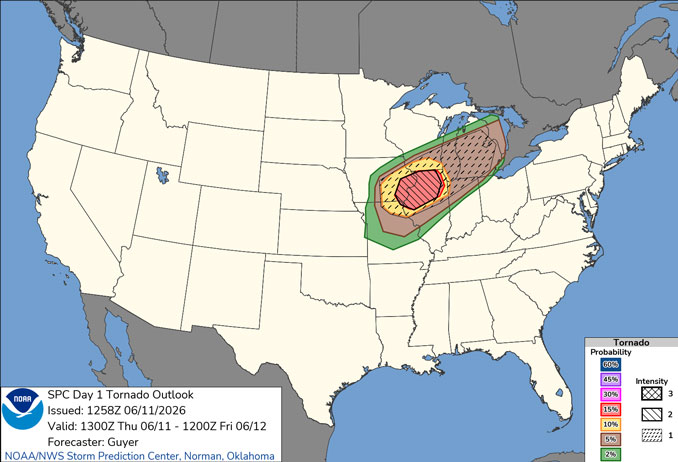
Another round or two of severe storms are expected today with the period of greatest threat between 4 and 11 PM. All hazards (tornadoes, destructive winds, destructive hail) are possible across the entire area.
In particular, there is a threat for strong to intense tornadoes this evening (4 to 8 PM) especially along and north of Interstate 88. Arlington Heights is at the east edge of the Level 2 Intensity Tornado Probability of 15% zone.
After a dry and cooler day on Friday, there is another threat for severe weather on Saturday.
See also: LIVE STREAMS: Arlingtoncardinal.com/StormChasers
O’HARE FORECAST …
Flood Watch
Flood Watch in effect from Thursday, June 11, 10:05 AM CDT until June 11, 11:00 PM CDT
Thursday: Showers and thunderstorms likely before 4pm, then a slight chance of showers and thunderstorms after 5pm. Partly sunny, with a high near 81. Breezy, with a south wind 10 to 20 mph, with gusts as high as 30 mph. Chance of precipitation is 70%. New rainfall amounts between a tenth and quarter of an inch, except higher amounts possible in thunderstorms.
Thursday Night: Showers and possibly a thunderstorm before 10pm, then a slight chance of showers between 10pm and 11pm. Low around 58. Breezy, with a south wind 15 to 20 mph becoming west 10 to 15 mph after midnight. Winds could gust as high as 35 mph. Chance of precipitation is 100%. New precipitation amounts between a quarter and half of an inch possible.
Friday: Sunny, with a high near 78. West wind 10 to 15 mph, with gusts as high as 25 mph.
Friday Night: Clear, with a low around 64. Southwest wind 5 to 10 mph, with gusts as high as 15 mph.
Saturday: Mostly sunny, with a high near 84. Southwest wind 10 to 15 mph, with gusts as high as 30 mph.
Saturday Night: Showers and possibly a thunderstorm. Low around 61. Chance of precipitation is 80%.
Sunday: Mostly sunny, with a high near 72.
Sunday Night: Mostly clear, with a low around 57.
RADAR • Clouds • Temps • NWS CHGO • UV
O’Hare Weather Forecast for THU JUN 11, 2026 10:36 AM SOURCE: National Weather Service local offices.
STORM PREDICTION SUMMARY…
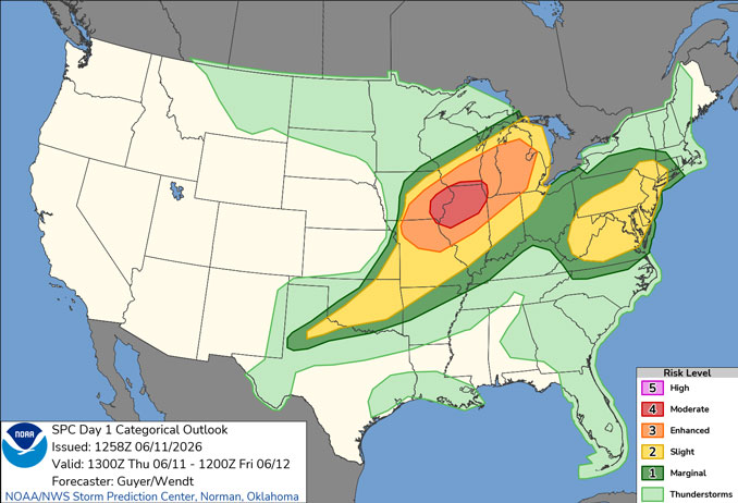
Widespread severe thunderstorms are expected across parts of the Midwest and Great Lakes region, including Iowa, northern Missouri, northern Illinois and southern Wisconsin to Lower Michigan and northern Indiana. This includes the potential for widespread/intense damaging winds, large hail, and tornadoes, some of which may be strong.
Midwest/Great Lakes… Portions of the region have been upgraded to a Moderate Risk. Another very active day with widespread/intense severe storms is expected regionally. A consequential severe risk is already ongoing this morning across Iowa/far northern Missouri, and will continue east-northeastward and become more prominent regionally during the day. A well-organized/eastward-accelerating bowing cluster of storms, now supported by an apparent MCV, has had a history of. measured severe-caliber wind gusts overnight and in the predawn hours from southeast Nebraska into southern Iowa. A similar severe risk should continue east-northeastward through midday across eastern Iowa/far northeast Missouri toward northern Illinois, with more of a surface-based/tornado risk potentially unfolding relatively early today aside from a continued prominent damaging wind threat.
Scenario is supported by a robust southwesterly low-level jet/moisture transport, even with some diurnal weakening of the low-level jet possible. Also influential is a prominent/increasingly neutral-tilt-shortwave trough and jet streak crossing the Corn Belt, notably strong features by mid-June standards.
Convective overturning/outflow from last evening’s MCS are still residual factors evident this morning in observational data/supplemental 3D mesoanalysis across far eastern Iowa, far northeast Missouri into central Illinois. This is sampled by the 12z observed sounding from KILX/Lincoln, IL. These residual factors may somewhat southward-focus the peak/most-intense severe weather later today, with more uncertainty progressively northward in general proximity to Lake Michigan latitudinally, including parts of Wisconsin/Michigan. The timing/residual impacts of this morning’s MCS across Iowa/northern Missouri into northern Illinois and severe potential in its wake near the surface low and front, and/or to its (MCS) north-northeast are a bit less uncertain. That said, mass response/fluxes related to the dynamic shortwave trough/speed max will be notable and consistent with heightened severe-potential even if outflow/cloud debris exists and sub-regional areas of destabilization are sub-optimal.
Details of later-afternoon severe potential is somewhat contingent on how the morning MCS further evolves, but a window for redevelopment in its immediate wake will probably exist. This will lead to a renewed round of severe storms as development occurs near the cold front, and perhaps preferentially favors prior outflow, with a damaging wind and tornado risk continuing eastward this evening as the low-level jet re=intensifies and as storms gradually grow upscale toward Lake Michigan and across Illinois/Indiana/Lower Michigan.
