
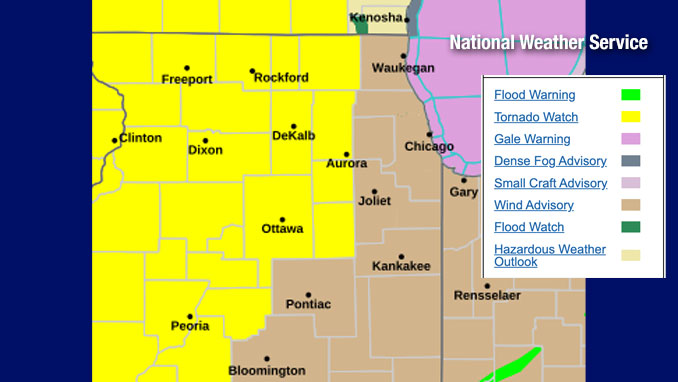
The NWS Storm Prediction Center indicates Arlington Heights and the surrounding communities outside the initial Tornado Watch are at significant risk of tornadoes. We’ll see if the NWS Chicago activates a Tornado Watch to include the rest of northeast Illinois later this afternoon.
Some thunderstorms Thursday afternoon may become severe. There is also a threat for tornadoes between 5 and 9 PM CST, especially along/west of I-39. A Tornado Watch was issued at 1:45 p.m. for many counties in Illinois, Iowa and Wisconsin but excludes Lake, Cook, Will, Kankakee, and Livingston County in northeast Illinois.
LIVE – TORNADO COVERAGE THU APR 2 2026 – Storm Chasers On The Ground…
Strong gusty south winds, gusting at times up to 45 to 50 mph are expected this afternoon, even outside of thunderstorms. A Wind Advisory for all of northern Illinois at 10:36 p.m. and is in effect until 7:00 p.m. Thursday.
There is another threat for severe weather Friday and Saturday, though the threats are conditional on placement of boundaries and system arrival timing.
Weather Radar at 2:15 p.m. shows precipitation with embed thunderstorms moving southwest to northeast.
Clouds show a flow from the southwest with some clearing in east Iowa and much of Missouri.
See also Arlingtoncardinal.com/clouds
O’HARE FORECAST …
Thursday Afternoon: Showers and possibly a thunderstorm. High near 69. Windy, with a south wind 20 to 30 mph, with gusts as high as 45 mph. Chance of precipitation is 90%. New rainfall amounts between a quarter and half of an inch possible.
Thursday Night: Showers and thunderstorms likely, mainly before midnight. Mostly cloudy, with a low around 47. Breezy, with a south southwest wind 20 to 25 mph decreasing to 15 to 20 mph after midnight. Winds could gust as high as 40 mph. Chance of precipitation is 70%. New rainfall amounts between a quarter and half of an inch possible.
Friday: Mostly cloudy, with a high near 57. West wind 5 to 10 mph becoming east in the afternoon.
Friday Night: Showers and possibly a thunderstorm. Low around 42. East northeast wind 10 to 15 mph becoming south after midnight. Winds could gust as high as 20 mph. Chance of precipitation is 100%.
Saturday: A 50 percent chance of showers, mainly before 1pm. Mostly cloudy, with a high near 63. Breezy, with a west southwest wind 15 to 20 mph, with gusts as high as 30 mph.
Saturday Night: Mostly cloudy, with a low around 36.
Sunday: Partly sunny, with a high near 51.
LAKE TEMPS …
Southern Lake Michigan Water Temperatures
National Weather Service Chicago/Romeoville IL
903 AM CDT Thu Apr 2 2026
Lake Michigan Water Temperatures…
Chicago Shore………..44.
Chicago Crib…………44.
Waukegan Buoy………..38.
Winthrop Harbor Buoy….38.
Michigan City………..42.
South Mid Lake Buoy…..38.
&&
M is for missing data that is normally available. Chicago Shore, Chicago Crib, and Michigan City are read every day of the year.
Measured at a depth of 60 ft for Chicago Crib and 30 ft for Michigan City. May not represent surface temperature.
april.chicagoweatherstation.com
Chicago Weather Forecast for your MAC/PC/TABLET includes surrounding suburbs.
^^ MOBILE? USE VOICE MIC ^^
facebook …
Please ‘LIKE’ the ‘Arlington Cardinal Page. See all of The Cardinal Facebook fan pages at Arlingtoncardinal.com/about/facebook …
Help fund The Cardinal Arlingtoncardinal.com/sponsor
