WIND GUSTS OVER 40 MPH 5:00 PM TO 10:00 PM TUESDAY
WIND ADVISORY in effect from February 12, 2:00 PM CST until February 13, 3:00 AM CST
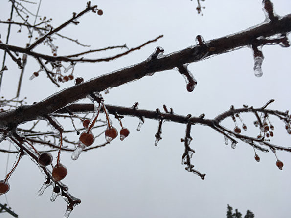
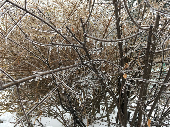
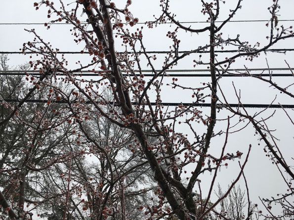
The Winter Weather Advisory was upgraded with an Ice Storm Warning overnight. Overnight there have been several small crashes and some transformer fires or lines down and lines down on trees. “Ice accretion” was measured as a crunchy snow-ice mix at 0.25 inch at 7:40 a.m. in Arlington Heights. High winds are forecast to begin about noon Tuesday and peak to 41 MPH from 5:00 p.m. to 11:00 p.m. and then taper off gradually to 17 MPH gusts about 5:00 p.m. Wednesday
Weather Radar (also nexrad.chgowx.com) shows precipitation moving southwest to northeast and ending over Arlington Heights by 7:30 a.m.
Julie Gammicchia shared this shocking video from southwest side of Chicago with us. Scenes like this could be repeated this afternoon & tonight as strong winds develop, taking a toll on power lines & tree limbs already weighted down by ice. Avoid downed wires, they could be live! pic.twitter.com/MoqOQB8oLj
— NWS Chicago (@NWSChicago) February 12, 2019
As of 6 AM, here are the official ice accretion measurements from across the area. pic.twitter.com/ZbanAx9lzk
— NWS Chicago (@NWSChicago) February 12, 2019
#Chicago: The rain that continues to fall early this morning in the city has changed over to ice and freezing rain:
-Sidewalks and streets are icy in spots
-Street lights and signs are covered in ice#ILwx @CNshooter @NWSChicago pic.twitter.com/F3opy0VGo6— Captured News (@CapturedNews) February 12, 2019
West winds 20-35 mph w/gusts of 40-50 mph likely late this afternoon & tonight. Power outages likely due to ice covered limbs & power lines. pic.twitter.com/u6bdBTqBeu
— NWS Chicago (@NWSChicago) February 12, 2019
Freezing rain has produced a layer of ice on most surfaces across the Joliet area this evening. #ilwx @NWSChicago pic.twitter.com/OhjusOTO1C
— Joliet Weather Center (@JolietWeather) February 12, 2019
O’HARE FORECAST …
Overnight: Freezing rain. Low around 30. East wind around 15 mph. Chance of precipitation is 80%. Total nighttime ice accumulation of 0.2 to 0.4 of an inch possible.
Tuesday: Drizzle and snow likely before noon, then rain and snow likely between noon and 2pm, then snow after 2pm. Widespread fog, mainly before 11am. Temperature rising to near 34 by 11am, then falling to around 30 during the remainder of the day. Breezy, with a light and variable wind becoming west 20 to 25 mph in the afternoon. Winds could gust as high as 40 mph. Chance of precipitation is 90%. New snow accumulation of less than one inch possible.
Tuesday Night: Snow likely, mainly before midnight. Cloudy, with a low around 17. Breezy, with a west wind 20 to 25 mph, with gusts as high as 40 mph. Chance of precipitation is 70%. New snow accumulation of less than one inch possible.
Wednesday: Partly sunny, with a high near 28. Wind chill values as low as 1. Blustery, with a west northwest wind 10 to 20 mph becoming southwest in the afternoon. Winds could gust as high as 30 mph.
Wednesday Night: Mostly cloudy, with a low around 25. South wind 5 to 10 mph, with gusts as high as 20 mph.
Thursday: A 40 percent chance of showers after noon. Mostly cloudy, with a high near 41.
Thursday Night: A chance of rain showers before 11pm, then a chance of snow showers and freezing rain between 11pm and midnight, then a slight chance of snow showers after midnight. Mostly cloudy, with a low around 19. Chance of precipitation is 40%.
Friday: A chance of snow showers after noon. Partly sunny, with a high near 26.
Friday Night: Mostly cloudy, with a low around 13.
Saturday: Partly sunny, with a high near 27.
Saturday Night: Mostly cloudy, with a low around 19.
Sunday: A chance of snow. Mostly cloudy, with a high near 28.
Sunday Night: A chance of snow. Mostly cloudy, with a low around 13.
Washington’s Birthday: A slight chance of snow. Partly sunny, with a high near 27.
ICE STORM WARNING …
URGENT – WINTER WEATHER MESSAGE
National Weather Service Chicago IL
418 AM CST Tue Feb 12 2019
ILZ008-010>014-019>022-INZ001-002-121500-
/O.CON.KLOT.IS.W.0002.000000T0000Z-190212T1500Z/
Ogle-Lee-DeKalb-Kane-DuPage-Cook-La Salle-Kendall-Grundy-Will-
Lake IN-Porter-
Including the cities of Oregon, Dixon, DeKalb, Aurora, Elgin,
Wheaton, Chicago, Ottawa, Oswego, Morris, Joliet, Gary,
and Valparaiso
418 AM CST Tue Feb 12 2019
…ICE STORM WARNING REMAINS IN EFFECT UNTIL 9 AM CST THIS
MORNING…
* WHAT…Significant icing. Total ice accumulations up to one half
inch.
* WHERE…Portions of northwest Indiana and north central and
northeast Illinois.
* WHEN…Freezing rain should taper off and end early this
morning.
* IMPACTS…Strong westerly winds are expected to develop this
afternoon and continue tonight. These strong winds will
increase the threat of power outages later today and tonight.
* ADDITIONAL DETAILS…Plan on slippery road conditions. The
hazardous conditions could impact the morning commute.
PRECAUTIONARY/PREPAREDNESS ACTIONS…
An Ice Storm Warning means significant amounts of ice
accumulation will make travel dangerous or impossible. Travel is
strongly discouraged. If you must travel, keep an extra
flashlight, food and water in your vehicle in case of an
emergency. Snapped power lines and falling tree branches are also
possible.
The latest road conditions for the state you are calling from can
be obtained by going to www.gettingaroundillinois.com in Illinois
or by calling 1 8 0 0 2 6 1 7 6 2 3 in Indiana.
&&
$$
Hazardous Weather Outlook
Hazardous Weather Outlook
National Weather Service Chicago/Romeoville IL
536 AM CST Tue Feb 12 2019
ILZ003>006-008-010>014-019>023-032-033-039-INZ001-002-010-011-019-
131145-
Winnebago-Boone-McHenry-Lake IL-Ogle-Lee-DeKalb-Kane-DuPage-Cook-
La Salle-Kendall-Grundy-Will-Kankakee-Livingston-Iroquois-Ford-
Lake IN-Porter-Newton-Jasper-Benton-
536 AM CST Tue Feb 12 2019 /636 AM EST Tue Feb 12 2019/
This Hazardous Weather Outlook is for portions of North Central
Illinois…Northeast Illinois and Northwest Indiana.
.DAY ONE…Today and Tonight.
Weather hazards expected…
Elevated Non thunderstorm wind Risk.
Significant Fog Risk.
Elevated Ice accumulation Risk.
Limited Snow Risk.
DISCUSSION…
Freezing rain, snow and some sleet will end early this morning.
Wind whipped snow showers are then expected to develop this
afternoon and continue tonight, potentially depositing some minor
accumulations.
Strong west winds, gusting to between 40 and 50 mph at times, will
develop this afternoon and continue tonight. The strong winds
could down ice covered tree limbs and power lines.
.DAYS TWO THROUGH SEVEN…Wednesday through Monday.
Wednesday…
Limited Non Thunderstorm Wind Risk.
Friday through Monday…
Limited Excessive Cold Risk.
LAKE TEMPS …
SOUTHERN LAKE MICHIGAN WATER TEMPERATURES
NATIONAL WEATHER SERVICE CHICAGO/ROMEOVILLE IL
900 AM CST Mon Feb 11 2019
LAKE MICHIGAN WATER TEMPERATURES…
CHICAGO SHORE……….34.
CHICAGO CRIB……….32.
MICHIGAN CITY……….33.
&&
M IS FOR MISSING DATA THAT IS NORMALLY AVAILABLE.
THE MICHIGAN CITY WATER TEMPERATURE SENSOR IS LOCATED AT A WATER
INTAKE ONE MILE OFFSHORE AND 60 FEET BELOW WATER SURFACE. IT IS READ EVERY DAY OF THE YEAR.
february.chicagoweatherstation.com
Chicago Weather Forecast for your MAC/PC/TABLET includes surrounding suburbs.
^^ MOBILE? USE VOICE MIC ^^
facebook …
GET ALERTS on Facebook.com/ArlingtonCardinal
GET ALERTS on Facebook.com/CardinalEmergencies
GET ALERTS on Facebook.com/ArlingtonHeightsCrime
Get updates from The Cardinal ALL NEWS FEEDS on Facebook. Just ‘LIKE’ the ‘Arlington Cardinal Page (become a fan of our page). The updates cover all posts and sub-category posts from The Cardinal — Arlingtoncardinal.com. You can also limit feeds to specific categories. See all of The Cardinal Facebook fan pages at Arlingtoncardinal.com/about/facebook …
Help fund The Cardinal Arlingtoncardinal.com/sponsor
20240105-1435future