


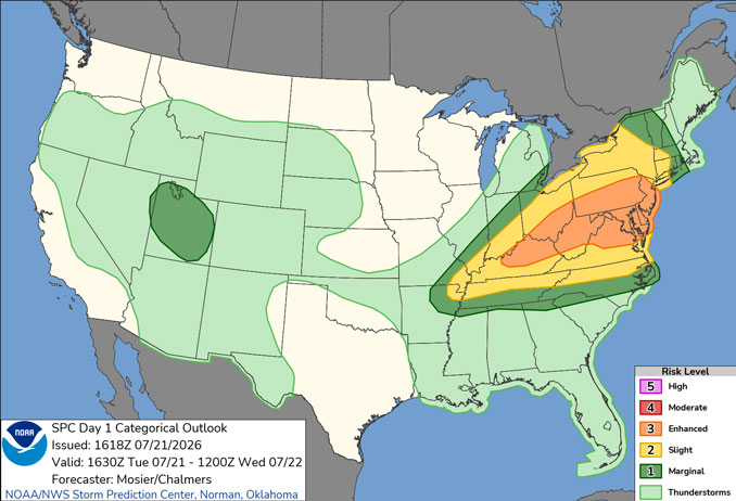
CHICAGOLAND DETAILS …
Radar is clear in northern Illinois at 3:00 p.m.
A cold front will move through the area Tuesday night leading to a period of cooler temperatures tonight through Wednesday night.
Temperatures will begin to drop about 4:00 p.m. and later with a small chance of rain about 7:00 p.m. to 11:00 p.m. The morning low Wednesday morning could hit 59 about 6:00 a.m.
Large waves will make swimming dangerous at all southern shore Lake Michigan beaches through early Thursday morning.
Arlington Heights reached the Good category of the Air Quality Index around 7:00 am. to 9:00 a.m. but quality worsened to Moderate during the day Tuesday. The Air Quality Index is forecast to be in the Good category Wednesday, July 22, 2026.
A trend toward warmer and more seasonable temperatures is expected toward the end of the week — back in the 80s by Friday with no rain in sight Tuesday night until Sunday night.
See also: LIVE STREAMS: Arlingtoncardinal.com/StormChasers
Temperature Outlook …
W 59 74 | R 59 79 | F 62 81 | SA 64 84
O’HARE FORECAST …
Beach Hazards Statement in effect from July 21, 04:00 PM CDT until July 22, 10:00 PM CDT
Tuesday Afternoon: Partly sunny, with a high near 86. Northwest wind around 15 mph, with gusts as high as 25 mph.
Tuesday Night: Scattered showers between 7pm and 11pm. Mostly cloudy, with a low around 59. North wind 10 to 15 mph, with gusts as high as 20 mph. Chance of precipitation is 30%.
Wednesday: Mostly sunny, with a high near 74. North northeast wind around 10 mph.
Wednesday Night: Mostly clear, with a low around 59. North northeast wind around 5 mph becoming calm in the evening.
Thursday: Sunny, with a high near 79. Calm wind becoming east southeast around 5 mph in the afternoon.
Thursday Night: Partly cloudy, with a low around 62.
Friday: Mostly sunny, with a high near 81.
Friday Night: Mostly clear, with a low around 64.
Saturday: Sunny, with a high near 84.
Saturday Night: Mostly clear, with a low around 70.
Sunday: Mostly sunny, with a high near 92.
Sunday Night: A chance of showers. Partly cloudy, with a low around 73.
RADAR • Clouds • Temps • NWS CHGO • UV

PHOENIX FORECAST …
Extreme Heat Warning in effect from July 23, 10:00 AM MST until July 27, 08:00 PM MST
Tuesday Afternoon: A 20 percent chance of showers and thunderstorms after 2pm. Partly sunny, with a high near 101. West wind around 5 mph.
Tuesday Night: A 50 percent chance of showers and thunderstorms, mainly before 9pm. Mostly cloudy, with a low around 85. West northwest wind around 5 mph becoming calm in the evening. New rainfall amounts of less than a tenth of an inch, except higher amounts possible in thunderstorms.
Wednesday: Sunny, with a high near 104. East wind around 5 mph becoming calm.
Wednesday Night: Mostly clear, with a low around 89. Calm wind.
Thursday: Sunny and hot, with a high near 110. Calm wind becoming east around 5 mph.
Thursday Night: Partly cloudy, with a low around 93. Calm wind.
Friday: Sunny and hot, with a high near 112. East southeast wind around 5 mph becoming west in the afternoon.
Friday Night: Mostly clear, with a low around 93. West wind around 5 mph.
Saturday: Sunny and hot, with a high near 113. West wind around 5 mph.
Saturday Night: A 10 percent chance of showers and thunderstorms before 11pm. Partly cloudy, with a low around 92. South wind around 5 mph.
Sunday: Mostly sunny and hot, with a high near 112. Calm wind becoming west around 5 mph in the afternoon.
Sunday Night: A 20 percent chance of showers and thunderstorms. Partly cloudy, with a low around 91. West southwest wind around 5 mph.
RADAR • Clouds • Temps • NWS Phoenix • UV

MIAMI FORECAST …
Tuesday Night: A 10 percent chance of showers and thunderstorms after 4am. Partly cloudy, with a low around 81. Southeast wind 6 to 9 mph.
Wednesday: A 20 percent chance of showers and thunderstorms, mainly between 9am and 10am. Mostly sunny, with a high near 91. Heat index values as high as 105. Southeast wind 6 to 10 mph.
Wednesday Night: Mostly clear, with a low around 81. East wind around 7 mph.
Thursday: Sunny, with a high near 92. Heat index values as high as 106. East wind 5 to 10 mph.
Thursday Night: A 20 percent chance of showers and thunderstorms after 2am. Partly cloudy, with a low around 81. East wind 5 to 8 mph.
Friday: A 40 percent chance of showers and thunderstorms, mainly after 8am. Mostly sunny, with a high near 91. Light east wind increasing to 5 to 9 mph in the morning.
Friday Night: A 20 percent chance of showers and thunderstorms before 2am. Mostly clear, with a low around 81. Southeast wind 3 to 7 mph.
Saturday: A 40 percent chance of showers and thunderstorms after 2pm. Sunny, with a high near 91. Light south wind becoming southeast 6 to 11 mph in the morning.
Saturday Night: A 30 percent chance of showers and thunderstorms before 8pm. Mostly clear, with a low around 80. South wind 3 to 6 mph.
Sunday: A 50 percent chance of showers and thunderstorms after 2pm. Sunny, with a high near 92.
Sunday Night: A 30 percent chance of showers and thunderstorms. Partly cloudy, with a low around 80.
Monday: A 30 percent chance of showers and thunderstorms. Mostly sunny, with a high near 92.
Monday Night: A 30 percent chance of showers and thunderstorms. Partly cloudy, with a low around 80.
RADAR • Clouds • Temps • NWS Miami • UV
LAX FORECAST …
High Surf Advisory until July 21, 11:00 PM PDT
Tuesday Afternoon: Sunny, with a high near 84. West southwest wind 10 to 15 mph, with gusts as high as 20 mph.
Tuesday Night: Patchy fog after 11pm. Otherwise, increasing clouds, with a low around 67. South southwest wind 5 to 15 mph, with gusts as high as 20 mph.
Wednesday: Patchy fog before 11am. Otherwise, cloudy through mid morning, then gradual clearing, with a high near 82. West southwest wind 5 to 10 mph increasing to 10 to 15 mph in the afternoon. Winds could gust as high as 20 mph.
Wednesday Night: Mostly clear, with a low around 67. West southwest wind 5 to 10 mph becoming east southeast after midnight.
Thursday: Sunny, with a high near 83. South wind 5 to 10 mph becoming west southwest in the morning. Winds could gust as high as 15 mph.
Thursday Night: Patchy fog after 11pm. Otherwise, mostly cloudy, with a low around 68.
Friday: Patchy fog before 11am. Otherwise, mostly sunny, with a high near 83.
Friday Night: Mostly clear, with a low around 69.
Saturday: Mostly sunny, with a high near 81.
Saturday Night: Mostly clear, with a low around 69.
Sunday: Mostly sunny, with a high near 81.
Sunday Night: Mostly clear, with a low around 70.
RADAR • Clouds • Temps • NWS Los Angeles • UV
WASH DC FORECAST …
Severe Thunderstorm Watch
Tuesday Afternoon: Scattered showers and thunderstorms, then showers and possibly a thunderstorm after 5pm. Some of the storms could be severe. High near 91. Southwest wind around 15 mph, with gusts as high as 20 mph. Chance of precipitation is 80%. New rainfall amounts between a tenth and quarter of an inch, except higher amounts possible in thunderstorms.
Tuesday Night: Showers and possibly a thunderstorm, mainly before 5am, then isolated showers and thunderstorms after 5am. Some of the storms could be severe. Low around 72. Southwest wind 8 to 15 mph, with gusts as high as 20 mph. Chance of precipitation is 80%. New rainfall amounts between a tenth and quarter of an inch, except higher amounts possible in thunderstorms.
Wednesday: A slight chance of showers, then a chance of showers and thunderstorms after 2pm. Partly sunny, with a high near 86. West wind 7 to 11 mph. Chance of precipitation is 50%.
Wednesday Night: A chance of showers and thunderstorms, mainly before 8pm. Mostly cloudy, with a low around 65. North wind around 8 mph. Chance of precipitation is 30%.
Thursday: Mostly sunny, with a high near 81. North wind 8 to 10 mph.
Thursday Night: Partly cloudy, with a low around 64.
Friday: Sunny, with a high near 81.
Friday Night: A slight chance of showers after 2am. Mostly cloudy, with a low around 65. Chance of precipitation is 20%.
Saturday: A slight chance of showers. Partly sunny, with a high near 81. Chance of precipitation is 20%.
Saturday Night: Partly cloudy, with a low around 66.
Sunday: A slight chance of showers and thunderstorms. Mostly sunny, with a high near 87. Chance of precipitation is 20%.
Sunday Night: A chance of showers and thunderstorms. Partly cloudy, with a low around 71. Chance of precipitation is 30%.
Monday: A chance of showers and thunderstorms. Mostly sunny, with a high near 91. Chance of precipitation is 30%.
Monday Night: A chance of showers and thunderstorms. Mostly cloudy, with a low around 73. Chance of precipitation is 40%.
Baltimore/Washington DC Forecast
RADAR • Clouds • Temps • NWS Baltimore/Washington • UV
O’Hare Weather Forecast Compared to Phoenix, Miami, LA, Wash DC TUE JUL 21, 2026 3:03 PM SOURCE: National Weather Service local offices.
