
CHICAGOLAND DETAILS …
Radar indicates precipitation over all of northern Illinois with lightning well south near Peoria and Champaign.
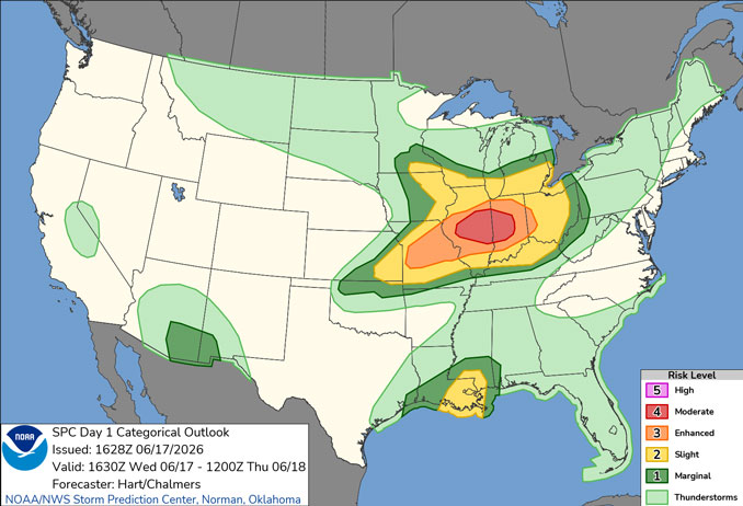
An outbreak of severe thunderstorms with the potential to produce damaging tornadoes, destructive straight line winds, and large hail is possible this afternoon into the early evening. Rain and thunder should start diminishing around 6:00 p.m. to 7:00 p.m.
A flood watch has been issued for today. Locally heavy rainfall is expected to result in an enhanced threat of localized flash flooding.
Tranquil weather is expected to close out the work week in the wake of this system.
Another strong storm system is expected to bring a return of showers and thunderstorms later this weekend, with some potential for heavy rainfall and/or severe weather somewhere in the general region.
See also: LIVE STREAMS: Arlingtoncardinal.com/StormChasers
O’HARE FORECAST …
Beach Hazards Statement
Beach Hazards Statement in effect from June 17, 01:00 PM CDT until June 18, 04:00 AM CDT
Flood Watch
Flood Watch until June 17, 09:00 PM CDT
Wind Advisory
Wind Advisory until June 17, 02:00 PM CDT
Wednesday Afternoon: Showers and possibly a thunderstorm before 5pm, then showers and thunderstorms likely after 5pm. Some of the storms could be severe and produce heavy rainfall. High near 68. Breezy, with a south wind 15 to 20 mph, with gusts as high as 30 mph. Chance of precipitation is 100%. New rainfall amounts between a half and three quarters of an inch possible.
Wednesday Night: Showers and thunderstorms likely before 10pm, then a slight chance of showers between 10pm and 11pm. Some of the storms could be severe. Mostly cloudy, then gradually becoming mostly clear, with a low around 60. West wind 10 to 15 mph, with gusts as high as 30 mph. Chance of precipitation is 60%. New precipitation amounts between a tenth and quarter of an inch, except higher amounts possible in thunderstorms.
Thursday: Mostly cloudy, then gradually becoming sunny, with a high near 73. West northwest wind 10 to 15 mph, with gusts as high as 25 mph.
Thursday Night: Partly cloudy, with a low around 57. West northwest wind 5 to 10 mph.
Friday: Sunny, with a high near 76. West northwest wind 5 to 15 mph, with gusts as high as 20 mph.
Friday Night: Partly cloudy, with a low around 60.
Saturday: A 20 percent chance of showers after 1pm. Mostly sunny, with a high near 79.
Saturday Night: Partly cloudy, with a low around 62.
Sunday: A chance of showers, then showers likely and possibly a thunderstorm after 1pm. Mostly cloudy, with a high near 74.
Sunday Night: Showers likely and possibly a thunderstorm before 1am, then a chance of showers. Mostly cloudy, with a low around 59.
RADAR • Clouds • Temps • NWS CHGO • UV

PHOENIX FORECAST …
Wednesday: Sunny, with a high near 108. Breezy, with a west southwest wind 10 to 15 mph, with gusts as high as 25 mph.
Wednesday Night: Clear, with a low around 83. West southwest wind 5 to 10 mph becoming light and variable after midnight. Winds could gust as high as 20 mph.
Thursday: Sunny, with a high near 106. Calm wind becoming west around 5 mph in the afternoon.
Thursday Night: Clear, with a low around 80. West southwest wind 5 to 10 mph becoming light west after midnight.
Friday: Sunny, with a high near 106. Calm wind becoming southwest around 5 mph in the afternoon.
Friday Night: Clear, with a low around 77. West southwest wind 5 to 10 mph becoming light and variable in the evening.
Saturday: Sunny, with a high near 104. Calm wind becoming west around 5 mph in the afternoon.
Saturday Night: Clear, with a low around 77. West wind around 5 mph becoming calm in the evening.
Sunday: Sunny, with a high near 104. Calm wind becoming west southwest around 5 mph in the afternoon.
Sunday Night: Clear, with a low around 77. West wind around 5 mph becoming calm after midnight.
RADAR • Clouds • Temps • NWS Phoenix • UV

MIAMI FORECAST …
Heat Advisory
Heat Advisory until June 17, 06:00 PM EDT
Wednesday Afternoon: A 30 percent chance of showers and thunderstorms, mainly after 3pm. Sunny, with a high near 92. Heat index values as high as 106. South wind around 11 mph.
Wednesday Night: A 10 percent chance of showers and thunderstorms before 8pm. Partly cloudy, with a low around 81. South wind 5 to 7 mph.
Thursday: Sunny, with a high near 92. Heat index values as high as 108. Southeast wind 6 to 11 mph.
Thursday Night: Partly cloudy, with a low around 81. Southeast wind 5 to 7 mph.
Friday: A 30 percent chance of showers and thunderstorms after 2pm. Mostly sunny, with a high near 91. Southeast wind 7 to 11 mph.
Friday Night: A 30 percent chance of showers and thunderstorms, mainly before 8pm. Mostly clear, with a low around 80. South wind 3 to 6 mph.
Saturday: Showers and thunderstorms likely after 2pm. Sunny, with a high near 91. Calm wind becoming southeast 5 to 8 mph in the afternoon. Chance of precipitation is 60%.
Saturday Night: Showers and thunderstorms likely, mainly before 8pm. Partly cloudy, with a low around 79. South wind around 5 mph becoming calm in the evening. Chance of precipitation is 60%.
Sunday: A 50 percent chance of showers and thunderstorms, mainly after 2pm. Mostly sunny, with a high near 92. Calm wind becoming southeast 5 to 8 mph in the afternoon.
Sunday Night: A 30 percent chance of showers and thunderstorms, mainly before 8pm. Partly cloudy, with a low around 80.
RADAR • Clouds • Temps • NWS Miami • UV

LAX FORECAST …
Beach Hazards Statement
Beach Hazards Statement until June 18, 03:00 AM PDT
Wednesday: Mostly cloudy, with a high near 71. West southwest wind 10 to 15 mph.
Wednesday Night: Patchy drizzle after 11pm. Cloudy, with a low around 62. West southwest wind 5 to 10 mph.
Thursday: Patchy drizzle before 11am. Mostly cloudy, with a high near 71. West southwest wind 5 to 10 mph increasing to 10 to 15 mph in the afternoon. Winds could gust as high as 20 mph.
Thursday Night: Patchy fog after 11pm. Otherwise, mostly cloudy, with a low around 60. West southwest wind 5 to 10 mph, with gusts as high as 15 mph.
Friday: Patchy drizzle before 11am. Mostly sunny, with a high near 69. Light west southwest wind increasing to 10 to 15 mph in the afternoon.
Friday Night: Patchy fog after 11pm. Otherwise, mostly cloudy, with a low around 60.
Saturday: Patchy fog before 11am. Otherwise, mostly sunny, with a high near 70.
Saturday Night: Partly cloudy, with a low around 59.
Sunday: Partly sunny, with a high near 69.
Sunday Night: Partly cloudy, with a low around 60.
RADAR • Clouds • Temps • NWS Los Angeles • UV

WASH DC FORECAST …
Wednesday Afternoon: Scattered sprinkles after 4pm. Mostly sunny, with a high near 88. South wind around 10 mph, with gusts as high as 20 mph.
Wednesday Night: Mostly cloudy, with a low around 71. South wind around 7 mph, with gusts as high as 18 mph.
Thursday: A slight chance of showers, then a chance of showers and thunderstorms after 2pm. Partly sunny, with a high near 94. Breezy, with a south wind 11 to 20 mph, with gusts as high as 33 mph. Chance of precipitation is 50%.
Thursday Night: A slight chance of showers and thunderstorms before 7pm, then a slight chance of showers after 2am. Mostly cloudy, with a low around 69. West wind 5 to 9 mph becoming light after midnight. Winds could gust as high as 18 mph. Chance of precipitation is 20%.
Friday: Mostly sunny, with a high near 85. Northwest wind 5 to 10 mph, with gusts as high as 18 mph.
Friday Night: Mostly clear, with a low around 64.
Saturday: Sunny, with a high near 85.
Saturday Night: Mostly clear, with a low around 64.
Sunday: Mostly sunny, with a high near 87.
Sunday Night: A slight chance of showers and thunderstorms, then a chance of showers after 2am. Mostly cloudy, with a low around 67. Chance of precipitation is 40%.
RADAR • Clouds • Temps • NWS Baltimore/Washington • UV
O’Hare Weather Forecast Compared to Phoenix, Miami, LA, Wash DC WED JUN 17, 2026 1:21 PM SOURCE: National Weather Service local offices.
