
CHICAGOLAND DETAILS …
Radar indicates a large area of precipitation in the form of showers and thunderstorms moving southwest to northeast over northeast Illinois around midnight. The trailing edge of the large area of precipitation on radar was approaching the Fox River at about 2:00 a.m.
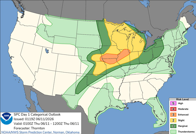
A second round of strong to severe thunderstorms affected the overnight Wednesday/Thursday beginning about 9:00 p.m. Wednesday in Arlington Heights and was expected to end by about 3:00 a.m. Thursday. Damaging wind gusts were a concern, along with flash flooding. The most significant hazard was steady rain and flooding, and the highest wind gusts at 39 MPH were about 9:51 p.m. Wednesday with no wind gusts after 10:00 p.m.
The total rainfall for the first round of thunderstorms Thursday afternoon was 0.52 inch at O’Hare. The second round of thunderstorms from 9:00 p.m. to 3:00 a.m. brought less than 0.25 inch at O’Hare.
More severe weather is expected Thursday afternoon and evening with a peak Heat Index of about 91°F about 3:00 p.m. to 4:00 p.m. Damaging winds, large hail, and tornadoes will all be possible, especially Thursday early evening. Thunderstorms are possible Thursday afternoon, but the severe thunderstorms are mostly likely to occur between 7:00 p.m. and 10:00 p.m.
Thursday will be another hot day with highs in the 80s and lower 90s and afternoon heat indices into the mid 90s.
Friday and Saturday will be dry and noticeably cooler. A generally cool and ocassional wet pattern will develop next week.
See also: LIVE STREAMS: Arlingtoncardinal.com/StormChasers
O’HARE FORECAST …
Overnight: Steady chance of showers and possibly a thunderstorm before 2am, then a chance of showers and thunderstorms between 2am and 4am. Low around 69. South southwest wind 10 to 15 mph, with gusts as high as 20 mph. Chance of precipitation is 90%. New rainfall amounts of less than a tenth of an inch, except higher amounts possible in thunderstorms.
Thursday: A 50 percent chance of showers and thunderstorms, mainly between 1pm and 4pm. Some of the storms could be severe. Partly sunny, with a high near 84. Breezy, with a south southwest wind 10 to 20 mph, with gusts as high as 30 mph.
Thursday Night: Showers and thunderstorms, mainly before 10pm. Some of the storms could be severe. Low around 58. Breezy, with a south southwest wind 15 to 20 mph becoming west 10 to 15 mph after midnight. Winds could gust as high as 35 mph. Chance of precipitation is 90%. New precipitation amounts between a quarter and half of an inch possible.
Friday: Sunny, with a high near 78. West wind 10 to 15 mph, with gusts as high as 25 mph.
Friday Night: Clear, with a low around 64. Southwest wind 5 to 10 mph, with gusts as high as 15 mph.
Saturday: Mostly sunny, with a high near 84.
Saturday Night: Showers and possibly a thunderstorm. Low around 61. Chance of precipitation is 80%.
Sunday: Mostly sunny, with a high near 72.
Sunday Night: Mostly clear, with a low around 57.
RADAR • Clouds • Temps • NWS CHGO • UV

PHOENIX FORECAST …
Thursday Night: Clear, with a low around 78. West wind around 5 mph becoming calm.
Thursday: Sunny, with a high near 107. Light and variable wind becoming west 5 to 10 mph in the afternoon.
Thursday Night: Mostly clear, with a low around 82. West wind 5 to 10 mph becoming light and variable after midnight.
Friday: Mostly sunny, with a high near 108. Light and variable wind becoming west 5 to 10 mph in the afternoon.
Friday Night: Partly cloudy, with a low around 84. West wind 5 to 10 mph becoming light west southwest after midnight.
Saturday: Mostly sunny, with a high near 108. West wind 5 to 10 mph.
Saturday Night: A 20 percent chance of showers and thunderstorms after 11pm. Partly cloudy, with a low around 84. West southwest wind around 5 mph.
Sunday: Sunny, with a high near 109. Light south southwest wind becoming west 5 to 10 mph in the afternoon.
Sunday Night: A 20 percent chance of showers and thunderstorms after 11pm. Mostly clear, with a low around 84. West southwest wind 5 to 10 mph.
RADAR • Clouds • Temps • NWS Phoenix • UV

MIAMI FORECAST …
Overnight: A 20 percent chance of showers. Mostly cloudy, with a low around 78. East wind around 6 mph.
Thursday: A 20 percent chance of showers before 10am. Partly sunny, with a high near 89. East wind 5 to 10 mph.
Thursday Night: Partly cloudy, with a low around 78. Southeast wind 3 to 7 mph.
Friday: A 30 percent chance of showers and thunderstorms, mainly between 2pm and 3pm. Partly sunny, with a high near 89. Calm wind becoming southeast 5 to 9 mph in the morning.
Friday Night: Mostly cloudy, with a low around 77. Southeast wind around 6 mph becoming calm in the evening.
Saturday: A 40 percent chance of showers and thunderstorms after 2pm. Sunny, with a high near 90. Calm wind becoming southeast 5 to 8 mph in the afternoon.
Saturday Night: A 30 percent chance of showers and thunderstorms before 8pm. Partly cloudy, with a low around 78. South wind around 6 mph becoming calm in the evening.
Sunday: A 40 percent chance of showers and thunderstorms after 2pm. Sunny, with a high near 90. Light and variable wind becoming southeast 5 to 10 mph in the afternoon.
Sunday Night: A 30 percent chance of showers and thunderstorms before 8pm. Partly cloudy, with a low around 78. South wind 3 to 7 mph.
RADAR • Clouds • Temps • NWS Miami • UV

LAX FORECAST …
High Surf Advisory
Coastal Hazard Message
234 PM PDT Wed Jun 10 2026
HIGH SURF ADVISORY REMAINS IN EFFECT UNTIL 8 PM PDT THURSDAY for Catalina and Santa Barbara Islands, Malibu Coast, and Los Angeles County Beaches
Large breaking waves of 4 to 7 feet, except 8 to 12 feet along Malibu. Dangerous rip currents.
There is an increased risk for ocean drowning. Rip currents can pull swimmers and surfers out to sea. Large breaking waves can cause injury, wash people off beaches and rocks, and capsize small boats near shore.
Remain out of the water due to dangerous surf conditions, or stay near occupied lifeguard towers. Rock jetties can be deadly in such conditions, stay off the rocks.
Thursday Night: Patchy fog. Otherwise, cloudy, with a low around 65. East southeast wind around 5 mph.
Thursday: Patchy fog before 11am. Otherwise, cloudy, then gradually becoming mostly sunny, with a high near 78. Southeast wind 5 to 10 mph becoming southwest in the afternoon.
Thursday Night: Patchy fog after 11pm. Otherwise, mostly cloudy, with a low around 63. West southwest wind 5 to 10 mph becoming light in the evening.
Friday: Patchy fog before 11am. Otherwise, cloudy through mid morning, then gradual clearing, with a high near 77. Light west wind becoming west southwest 10 to 15 mph in the afternoon.
Friday Night: Partly cloudy, with a low around 64. West southwest wind 5 to 10 mph becoming light in the evening.
Saturday: Patchy fog before 11am. Otherwise, mostly sunny, with a high near 77.
Saturday Night: Patchy fog after 11pm. Otherwise, mostly cloudy, with a low around 63.
Sunday: Patchy fog before 11am. Otherwise, mostly sunny, with a high near 73.
Sunday Night: Partly cloudy, with a low around 62.
RADAR • Clouds • Temps • NWS Los Angeles • UV

WASH DC FORECAST …
Heat Advisory
224 AM EDT Thu Jun 11 2026
HEAT ADVISORY IN EFFECT FROM 11 AM THURSDAY MORNING TO 8 PM EDT THURSDAY
EVENING
District of Columbia-Cecil-Southern Baltimore-Prince Georges-Anne Arundel-Charles-St. Marys-Calvert-Southeast Harford-Arlington/Falls Church/Alexandria-King George
Areas near and east of the Interstate 95 corridor from northeast to southern Maryland and the northern neck of Virginia, including Baltimore MD and Washington DC.
Heat index values up to 105 expected.
Overnight: Patchy fog after 5am. Otherwise, partly cloudy, with a low around 70. Southwest wind around 5 mph becoming calm.
Thursday: Mostly sunny, with a high near 96. Heat index values as high as 105. West wind 3 to 7 mph.
Thursday Night: A chance of showers and thunderstorms, mainly before 10pm. Mostly cloudy, with a low around 73. Light southwest wind. Chance of precipitation is 30%.
Friday: A slight chance of showers and thunderstorms between 3pm and 4pm, then showers likely and possibly a thunderstorm after 4pm. Increasing clouds and hot, with a high near 97. Heat index values as high as 102. Calm wind becoming west 5 to 8 mph in the morning. Chance of precipitation is 60%. New rainfall amounts between a quarter and half of an inch possible.
Friday Night: Showers and thunderstorms likely before 11pm, then a chance of showers between 11pm and 2am. Mostly cloudy, with a low around 67. Northwest wind around 7 mph. Chance of precipitation is 60%.
Saturday: Sunny, with a high near 89.
Saturday Night: Mostly clear, with a low around 67.
Sunday: A chance of showers and thunderstorms after 2pm. Partly sunny, with a high near 92. Chance of precipitation is 40%.
Sunday Night: A chance of showers and thunderstorms before 8pm, then showers likely and possibly a thunderstorm between 8pm and 2am, then a slight chance of showers after 2am. Mostly cloudy, with a low around 67. Chance of precipitation is 60%.
RADAR • Clouds • Temps • NWS Baltimore/Washington • UV
O’Hare Weather Forecast Compared to Phoenix, Miami, LA, Wash DC WED JUN 10, 2026 11:52 PM SOURCE: National Weather Service local offices.
