
CHICAGOLAND DETAILS …
Radar is clear in Illinois.
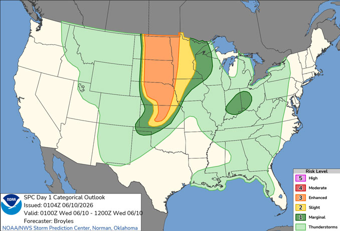
A sight chance exists for a few thunderstorms later tonight into early Wednesday. While potential is low, it`s possible that a storm becomes severe.
Wednesday and Thursday will be hot and humid with peak heat indices in the 90s to locally 100. The hottest conditions are favored on Wednesday including up to the Lake Michigan shoreline.
A few rounds of severe thunderstorms may occur in the general region Wednesday through Thursday. Thursday continues to look like the most concerning day for severe weather locally.
Friday and Saturday will be dry and noticeably cooler. A generally cool and at times wet pattern will develop next week.
See also: LIVE STREAMS: Arlingtoncardinal.com/StormChasers
O’HARE FORECAST …
Overnight: A 30 percent chance of showers and thunderstorms, mainly after 5am. Patchy fog after midnight. Otherwise, mostly cloudy, with a low around 71. East wind around 5 mph becoming south southeast after midnight.
Wednesday: Showers and thunderstorms likely, mainly between 3pm and 5pm. Some of the storms could be severe and produce heavy rainfall. Partly sunny, with a high near 92. Heat index values as high as 100. Breezy, with a southwest wind 10 to 15 mph increasing to 15 to 20 mph in the afternoon. Winds could gust as high as 30 mph. Chance of precipitation is 70%. New rainfall amounts between a quarter and half of an inch possible.
Wednesday Night: Showers and thunderstorms likely, mainly before 3am. Some of the storms could be severe and produce heavy rainfall. Mostly cloudy, with a low around 74. Southwest wind 10 to 15 mph, with gusts as high as 30 mph. Chance of precipitation is 70%. New rainfall amounts between a tenth and quarter of an inch, except higher amounts possible in thunderstorms.
Thursday: Showers and thunderstorms likely after 1pm. Partly sunny, with a high near 90. Heat index values as high as 96. Breezy, with a south wind 5 to 10 mph increasing to 15 to 20 mph in the afternoon. Winds could gust as high as 30 mph. Chance of precipitation is 70%.
Thursday Night: Showers and possibly a thunderstorm before 1am. Low around 64. Breezy, with a south southwest wind 10 to 20 mph becoming west northwest after midnight. Winds could gust as high as 30 mph. Chance of precipitation is 90%.
Friday: Sunny, with a high near 78.
Friday Night: Mostly clear, with a low around 63.
Saturday: Sunny, with a high near 86.
Saturday Night: A chance of showers and thunderstorms, then showers likely after 1am. Partly cloudy, with a low around 64.
RADAR • Clouds • Temps • NWS CHGO • UV

PHOENIX FORECAST …
Overnight: Clear, with a low around 75. Calm wind.
Wednesday: Sunny, with a high near 107. Calm wind becoming west around 5 mph in the afternoon.
Wednesday Night: Clear, with a low around 77. West wind around 5 mph becoming calm after midnight.
Thursday: Sunny, with a high near 107. Calm wind becoming west around 5 mph in the afternoon.
Thursday Night: Partly cloudy, with a low around 80. West southwest wind around 5 mph becoming calm after midnight.
Friday: A 10 percent chance of showers and thunderstorms before 8am. Mostly sunny, with a high near 107. Calm wind becoming west around 5 mph in the afternoon.
Friday Night: Partly cloudy, with a low around 82. West southwest wind around 5 mph.
Saturday: Sunny, with a high near 109. Light and variable wind becoming west 5 to 10 mph in the afternoon.
Saturday Night: Mostly clear, with a low around 83. West wind 5 to 10 mph becoming light after midnight.
RADAR • Clouds • Temps • NWS Phoenix • UV

MIAMI FORECAST …
Overnight: Mostly cloudy, with a low around 79. East wind around 8 mph.
Wednesday: Isolated showers and thunderstorms between noon and 2pm. Partly sunny, with a high near 88. East wind 8 to 11 mph. Chance of precipitation is 20%.
Wednesday Night: Mostly cloudy, with a low around 78. East wind 6 to 8 mph.
Thursday: Isolated showers, then scattered showers and thunderstorms after 11am. Mostly sunny, with a high near 89. East wind 5 to 10 mph. Chance of precipitation is 30%.
Thursday Night: Scattered showers and thunderstorms before 8pm. Mostly cloudy, with a low around 78. East wind 3 to 7 mph. Chance of precipitation is 30%.
Friday: Scattered showers and thunderstorms, mainly after 2pm. Partly sunny, with a high near 89. Calm wind becoming east 5 to 8 mph in the afternoon. Chance of precipitation is 30%.
Friday Night: Scattered showers and thunderstorms before 8pm. Partly cloudy, with a low around 77. Southeast wind around 6 mph becoming calm in the evening. Chance of precipitation is 30%.
Saturday: A 40 percent chance of showers and thunderstorms after 2pm. Mostly sunny, with a high near 89. Light and variable wind becoming southeast 5 to 10 mph in the afternoon.
Saturday Night: A 30 percent chance of showers and thunderstorms before 8pm. Partly cloudy, with a low around 78. South wind 5 to 7 mph becoming calm after midnight.
RADAR • Clouds • Temps • NWS Miami • UV

LAX FORECAST …
High Surf Advisory
Coastal Hazard Message
128 PM PDT Tue Jun 9 2026
HIGH SURF ADVISORY IN EFFECT UNTIL 8 PM PDT THURSDAY for the Catalina and Santa Barbara Islands-Malibu Coast-Los Angeles County Beaches
Large breaking waves of 4 to 7 feet, except 7 to 10 feet along Malibu. Dangerous rip currents. There is an increased risk for ocean drowning.
Overnight: Partly cloudy, with a low around 63. Southwest wind around 5 mph becoming east southeast after midnight.
Wednesday: Mostly sunny, with a high near 76. Southeast wind 5 to 10 mph becoming southwest in the morning.
Wednesday Night: Patchy fog after 11pm. Otherwise, increasing clouds, with a low around 64. Southwest wind 5 to 10 mph becoming southeast after midnight.
Thursday: Patchy fog before 11am. Otherwise, cloudy through mid morning, then gradual clearing, with a high near 75. Southeast wind 5 to 10 mph becoming southwest in the afternoon.
Thursday Night: Patchy fog after 11pm. Otherwise, mostly cloudy, with a low around 64. Southwest wind 5 to 10 mph becoming light west southwest in the evening.
Friday: Patchy fog before 11am. Otherwise, mostly sunny, with a high near 75.
Friday Night: Partly cloudy, with a low around 62.
Saturday: Mostly sunny, with a high near 73.
Saturday Night: Mostly clear, with a low around 62.
RADAR • Clouds • Temps • NWS Los Angeles • UV

WASH DC FORECAST …
Overnight: Mostly cloudy, with a low around 69. South wind around 5 mph.
Wednesday: A chance of showers and thunderstorms, mainly after 2pm. Mostly cloudy, with a high near 89. Southwest wind 6 to 9 mph. Chance of precipitation is 50%.
Wednesday Night: A chance of showers and thunderstorms, mainly before 7pm. Partly cloudy, with a low around 71. Southwest wind around 5 mph becoming calm in the evening. Chance of precipitation is 30%.
Thursday: A chance of showers and thunderstorms after 2pm. Mostly sunny, with a high near 96. Heat index values as high as 103. West wind 3 to 7 mph. Chance of precipitation is 40%.
Thursday Night: A chance of showers and thunderstorms before 2am. Mostly cloudy, with a low around 73. Light west wind. Chance of precipitation is 40%.
Friday: A chance of showers and thunderstorms after 2pm. Mostly sunny and hot, with a high near 97. Chance of precipitation is 40%.
Friday Night: A chance of showers and thunderstorms before 2am. Mostly cloudy, with a low around 70. Chance of precipitation is 50%.
Saturday: Sunny, with a high near 91.
Saturday Night: Mostly clear, with a low around 68.
RADAR • Clouds • Temps • NWS Baltimore/Washington • UV
O’Hare Weather Forecast Compared to Phoenix, Miami, LA, Wash DC TUE JUN 09, 2026 11:53 PM SOURCE: National Weather Service local offices.
