
CHICAGOLAND DETAILS …
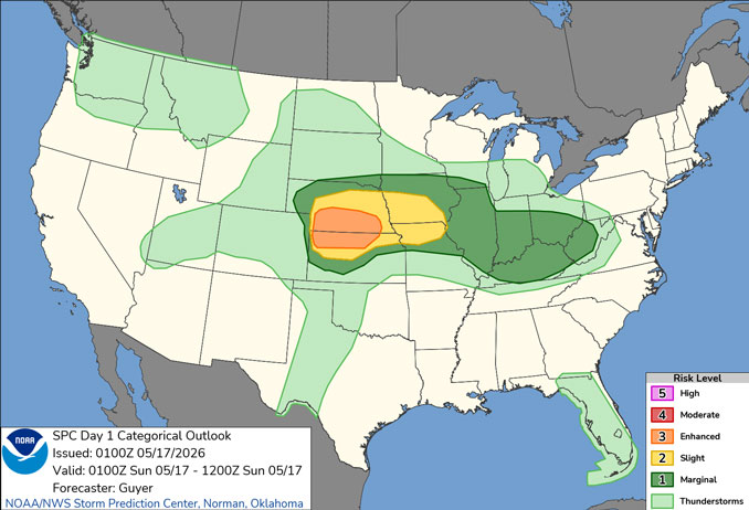
An elevated chance for showers and storms Saturday/Sunday evening-overnight, especially with westward extent, and then a few showers and storms may linger past daybreak Sunday, mainly north of I-88. A large area of rain and storm precipitation is crawling eastward near the Mississippi River at midnight Saturday/Sunday.
Expect more widespread showers and at least scattered storms at times Monday-Tuesday, some of which may be severe.
Summer-like warmth in the 80s with high humidity along with frequently gusty south to southwest winds will continue through early next week. Cooler conditions then return Wednesday.
See also: LIVE STREAMS: Arlingtoncardinal.com/StormChasers
O’HARE FORECAST …
Overnight: A 30 percent chance of showers and thunderstorms, mainly after 3am. Mostly cloudy, with a low around 62. Southwest wind around 5 mph.
Sunday: A 30 percent chance of showers and thunderstorms, mainly before 11am. Mostly cloudy, with a high near 86. Breezy, with an east wind 5 to 10 mph becoming south 15 to 20 mph in the afternoon. Winds could gust as high as 30 mph.
Sunday Night: Partly cloudy, with a low around 69. South wind around 15 mph, with gusts as high as 25 mph.
Monday: A chance of showers and thunderstorms, then showers and possibly a thunderstorm after 1pm. High near 84. Breezy, with a south southwest wind 15 to 20 mph, with gusts as high as 30 mph. Chance of precipitation is 80%.
Monday Night: A chance of showers and thunderstorms, then showers likely and possibly a thunderstorm after 1am. Mostly cloudy, with a low around 68. South southwest wind around 15 mph, with gusts as high as 30 mph. Chance of precipitation is 60%.
Tuesday: A chance of showers and thunderstorms, then showers likely and possibly a thunderstorm after 1pm. Mostly cloudy, with a high near 84. Breezy. Chance of precipitation is 70%.
Tuesday Night: A 20 percent chance of showers before 1am. Mostly cloudy, with a low around 51.
Wednesday: Partly sunny, with a high near 63.
Wednesday Night: Mostly cloudy, with a low around 45.
RADAR • Clouds • Temps • NWS CHGO • UV

PHOENIX FORECAST …
Sunday Night: Clear, with a low around 69. Southwest wind 5 to 10 mph becoming east northeast after midnight. Winds could gust as high as 20 mph.
Sunday: Sunny, with a high near 93. South southeast wind 5 to 10 mph becoming southwest in the afternoon. Winds could gust as high as 20 mph.
Sunday Night: Mostly clear, with a low around 66. Breezy, with a southwest wind 10 to 15 mph decreasing to 5 to 10 mph after midnight. Winds could gust as high as 30 mph.
Monday: Partly sunny, then gradually becoming sunny, with a high near 87. South southwest wind 5 to 10 mph.
Monday Night: Clear, with a low around 65. West southwest wind around 5 mph becoming calm in the evening.
Tuesday: Sunny, with a high near 91. Calm wind becoming west around 5 mph in the afternoon.
Tuesday Night: Partly cloudy, with a low around 68. West wind around 5 mph becoming calm.
Wednesday: Mostly sunny, with a high near 95. Calm wind becoming west around 5 mph in the afternoon.
Wednesday Night: Mostly clear, with a low around 69. West wind around 5 mph becoming calm.
RADAR • Clouds • Temps • NWS Phoenix • UV

MIAMI FORECAST …
Rip Current Statement
413 PM EDT Sat May 16 2026
HIGH RIP CURRENT RISK IN EFFECT FROM SUNDAY MORNING THROUGH
MONDAY EVENING… for Coastal Broward County-Coastal Miami Dade County
Overnight: A 20 percent chance of showers and thunderstorms. Mostly cloudy, with a low around 79. East wind around 8 mph.
Sunday: A 40 percent chance of showers and thunderstorms, mainly between 10am and 3pm. Partly sunny, with a high near 86. East wind 9 to 13 mph, with gusts as high as 18 mph.
Sunday Night: A 30 percent chance of showers and thunderstorms, mainly after 1am. Partly cloudy, with a low around 79. East wind around 10 mph, with gusts as high as 18 mph.
Monday: Showers likely and possibly a thunderstorm before 2pm, then a chance of showers and thunderstorms after 2pm. Mostly sunny, with a high near 87. East wind 10 to 14 mph, with gusts as high as 21 mph. Chance of precipitation is 60%.
Monday Night: A chance of showers and thunderstorms before 11pm, then a chance of showers between 11pm and 2am, then a chance of showers and thunderstorms after 2am. Partly cloudy, with a low around 79. East wind 9 to 11 mph, with gusts as high as 20 mph. Chance of precipitation is 40%.
Tuesday: A 40 percent chance of showers and thunderstorms. Sunny, with a high near 86. East wind 9 to 13 mph, with gusts as high as 20 mph.
Tuesday Night: A 30 percent chance of showers and thunderstorms. Partly cloudy, with a low around 79. East wind 8 to 11 mph, with gusts as high as 18 mph.
Wednesday: A 30 percent chance of showers and thunderstorms, mainly before 2pm. Sunny, with a high near 86. East wind 8 to 13 mph, with gusts as high as 18 mph.
Wednesday Night: A 30 percent chance of showers and thunderstorms, mainly after 2am. Partly cloudy, with a low around 79. East wind 6 to 10 mph.
RADAR • Clouds • Temps • NWS Miami • UV

LAX FORECAST …
Beach Hazards Statement
955 PM PDT Sat May 16 2026
BEACH HAZARDS STATEMENT REMAINS IN EFFECT THROUGH MONDAY
MORNING for Malibu Coast-Los Angeles County Beaches
Sunday Night: Mostly clear early, then becoming cloudy, with a low around 60. East southeast wind 5 to 10 mph.
Sunday: Cloudy, then gradually becoming mostly sunny, with a high near 70. East southeast wind 5 to 15 mph becoming west southwest in the afternoon. Winds could gust as high as 20 mph.
Sunday Night: Patchy fog after 11pm. Otherwise, increasing clouds, with a low around 60. Southwest wind 10 to 15 mph becoming east southeast in the evening.
Monday: Patchy fog before 11am. Otherwise, cloudy through mid morning, then gradual clearing, with a high near 73. East southeast wind 5 to 15 mph becoming west southwest in the afternoon. Winds could gust as high as 20 mph.
Monday Night: Partly cloudy, with a low around 60. West southwest wind 5 to 15 mph becoming east after midnight.
Tuesday: Patchy fog before 11am. Otherwise, mostly sunny, with a high near 74.
Tuesday Night: Mostly clear, with a low around 61.
Wednesday: Mostly sunny, with a high near 74.
Wednesday Night: Partly cloudy, with a low around 59.
RADAR • Clouds • Temps • NWS Los Angeles • UV

WASH DC FORECAST …
Overnight: Partly cloudy, with a low around 65. Light southwest wind.
Sunday: Mostly sunny, with a high near 89. Calm wind becoming west around 6 mph in the afternoon.
Sunday Night: Partly cloudy, with a low around 66. Light southeast wind.
Monday: Sunny, with a high near 94. Calm wind becoming south 5 to 8 mph in the afternoon.
Monday Night: Mostly clear, with a low around 70. South wind 5 to 7 mph.
Tuesday: Sunny, with a high near 96.
Tuesday Night: Partly cloudy, with a low around 73.
Wednesday: A chance of showers and thunderstorms after 2pm. Mostly sunny, with a high near 96. Chance of precipitation is 50%.
Wednesday Night: A chance of showers and thunderstorms before 8pm, then showers likely and possibly a thunderstorm between 8pm and 2am, then a chance of showers after 2am. Mostly cloudy, with a low around 65. Chance of precipitation is 60%.
RADAR • Clouds • Temps • NWS Baltimore/Washington • UV
O’Hare Weather Forecast Compared to Phoenix, Miami, LA, Washington DC SAT MAY 16, 2026 11:56 PM
