


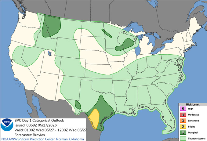
CHICAGOLAND DETAILS …
Generally above normal temperatures (highs in the 80s) and dry conditions are expected through early next week. Onshore winds will keep temperatures cooler near Lake Michigan each day (60s-70s).
Backdoor cold fronts will lead to cooler conditions (60s and 70s) extending farther inland late Wednesday into Thursday and potentially again over the weekend.
See also: LIVE STREAMS: Arlingtoncardinal.com/StormChasers
O’HARE FORECAST …
Air Quality Alert
AIR QUALITY ALERT IN EFFECT NOW THROUGH WEDNESDAY NIGHT…
Ozone is expected to be the primary pollutant of concern.
The Illinois Environmental Protection Agency has determined that an Air Pollution Action Day will be declared for the greater Chicago Metropolitan Area through Wednesday Night.
A Chicago area Air Pollution Action Day is declared when weather conditions are such that widespread ozone and or particulate levels are expected to be at or above the Unhealthy for Sensitive Groups category of the Air Quality Index for multiple days.
Beach Hazards Statement
Coastal Hazard Message
933 PM CDT Tue May 26 2026
BEACH HAZARDS STATEMENT REMAINS IN EFFECT FROM WEDNESDAY EVENING THROUGH LATE THURSDAY NIGHT with high wave action and dangerous currents expected at Lake Michigan beaches in Lake IL, Northern Cook, and Central Cook. Waves 4 to 7 ft expected.
Overnight Tuesday/Wednesday: Partly cloudy, with a low around 62 about 5am Wednesday. South southeast wind around 5 mph becoming west.
Wednesday: Mostly sunny, with a high near 82 about 2pm. North northwest wind 5 to 10 mph becoming east northeast in the afternoon.
Wednesday Night: Partly cloudy, with a low around 55. North northeast wind 10 to 15 mph, with gusts as high as 25 mph.
Thursday: Sunny, with a high near 70. Northeast wind 10 to 15 mph, with gusts as high as 20 mph.
Thursday Night: Mostly clear, with a low around 53. Northeast wind 5 to 10 mph, with gusts as high as 15 mph.
Friday: Sunny, with a high near 80.
Friday Night: Mostly clear, with a low around 59.
Saturday: Sunny, with a high near 79.
Saturday Night: Mostly clear, with a low around 57.
RADAR • Clouds • Temps • NWS CHGO • UV

PHOENIX FORECAST …
Wednesday Night: Clear, with a low around 68. West southwest wind around 5 mph becoming calm after midnight.
Wednesday: Sunny, with a high near 94. Light south southeast wind becoming south southwest 5 to 10 mph in the morning. Winds could gust as high as 20 mph.
Wednesday Night: Clear, with a low around 66. Breezy, with a southwest wind 10 to 15 mph becoming light and variable in the evening. Winds could gust as high as 25 mph.
Thursday: Sunny, with a high near 93. Light south wind becoming southwest 5 to 10 mph in the morning.
Thursday Night: Clear, with a low around 66. West southwest wind 5 to 10 mph becoming light in the evening. Winds could gust as high as 20 mph.
Friday: Sunny, with a high near 90. Light west southwest wind becoming west 5 to 10 mph in the afternoon.
Friday Night: Clear, with a low around 67. West wind 5 to 10 mph becoming light south southwest in the evening.
Saturday: Sunny, with a high near 93. Calm wind becoming west around 5 mph in the afternoon.
Saturday Night: Clear, with a low around 70. West wind around 5 mph becoming calm in the evening.
RADAR • Clouds • Temps • NWS Phoenix • UV

MIAMI FORECAST …
Rip Current Statement
Coastal Hazard Message
422 PM EDT Tue May 26 2026
HIGH RIP CURRENT RISK REMAINS IN EFFECT THROUGH WEDNESDAY
EVENING for Coastal Broward County, Coastal Miami Dade County-
OvernightTuesday/Wednesday: A 30 percent chance of showers before 2am. Partly cloudy, with a low around 79. Southeast wind around 10 mph, with gusts as high as 20 mph.
Wednesday: A slight chance of showers between 10am and 11am. Mostly sunny, with a high near 88. Southeast wind 11 to 14 mph, with gusts as high as 22 mph. Chance of precipitation is 20%.
Wednesday Night: A chance of showers and thunderstorms before 3am, then a slight chance of showers between 3am and 4am. Mostly cloudy, with a low around 79. Southeast wind 7 to 9 mph. Chance of precipitation is 30%.
Thursday: A 50 percent chance of showers and thunderstorms, mainly after 1pm. Partly sunny, with a high near 88. Southeast wind 8 to 10 mph.
Thursday Night: A 50 percent chance of showers and thunderstorms before 2am. Mostly cloudy, with a low around 77. South wind around 6 mph becoming calm in the evening.
Friday: A slight chance of showers before 11am, then a slight chance of showers and thunderstorms between 11am and 2pm, then showers likely and possibly a thunderstorm after 2pm. Partly sunny, with a high near 89. Calm wind becoming southeast 5 to 8 mph in the afternoon. Chance of precipitation is 60%.
Friday Night: Showers and thunderstorms likely before 11pm, then a slight chance of showers between 11pm and 2am. Mostly cloudy, with a low around 78. South wind around 6 mph. Chance of precipitation is 60%.
Saturday: A slight chance of thunderstorms, then a chance of showers and thunderstorms after 8am. Mostly cloudy, with a high near 89. Light southwest wind becoming south 5 to 9 mph in the morning. Chance of precipitation is 50%.
Saturday Night: A chance of showers and thunderstorms. Mostly cloudy, with a low around 78. South wind around 6 mph. Chance of precipitation is 40%.
RADAR • Clouds • Temps • NWS Miami • UV
LAX FORECAST …
Overnight Tuesday/Wednesday: Partly cloudy early, then becoming cloudy, with a low around 59. West southwest wind 5 to 15 mph becoming southeast after midnight. Winds could gust as high as 20 mph.
Wednesday: Patchy drizzle before 11am. Cloudy through mid morning, then gradual clearing, with a high near 68. East southeast wind 10 to 15 mph becoming west southwest in the afternoon. Winds could gust as high as 20 mph.
Wednesday Night: Increasing clouds, with a low around 58. West southwest wind 10 to 15 mph decreasing to 5 to 10 mph after midnight. Winds could gust as high as 20 mph.
Thursday: Cloudy, then gradually becoming mostly sunny, with a high near 68. Light and variable wind becoming west southwest 10 to 15 mph in the morning. Winds could gust as high as 20 mph.
Thursday Night: Partly cloudy, with a low around 59. West northwest wind 5 to 15 mph.
Friday: Mostly sunny, with a high near 70.
Friday Night: Patchy fog after 11pm. Otherwise, mostly cloudy, with a low around 60.
Saturday: Patchy fog before 11am. Otherwise, mostly sunny, with a high near 73.
Saturday Night: Mostly clear, with a low around 59.
RADAR • Clouds • Temps • NWS Los Angeles • UV
WASH DC FORECAST …
Overnight Tuesday/Wednesday: Showers likely and possibly a thunderstorm. Patchy fog. Otherwise, cloudy, with a low around 65. Calm wind. Chance of precipitation is 60%. New rainfall amounts of less than a tenth of an inch, except higher amounts possible in thunderstorms.
Wednesday: A chance of showers before 11am, then a chance of showers and thunderstorms between 11am and 2pm, then showers and possibly a thunderstorm after 2pm. Patchy fog before 11am. High near 81. Calm wind becoming west around 6 mph in the afternoon. Chance of precipitation is 90%. New rainfall amounts between a tenth and quarter of an inch, except higher amounts possible in thunderstorms.
Wednesday Night: Showers and thunderstorms likely before 3am, then a chance of showers. Patchy fog between 11pm and midnight. Otherwise, mostly cloudy, with a low around 64. Light and variable wind. Chance of precipitation is 60%. New precipitation amounts between a tenth and quarter of an inch, except higher amounts possible in thunderstorms.
Thursday: Mostly cloudy, then gradually becoming sunny, with a high near 79. North wind 5 to 10 mph.
Thursday Night: Mostly clear, with a low around 57. North wind 3 to 5 mph.
Friday: Sunny, with a high near 78.
Friday Night: Mostly clear, with a low around 59.
Saturday: Mostly sunny, with a high near 78.
Saturday Night: Partly cloudy, with a low around 55.
RADAR • Clouds • Temps • NWS Baltimore/Washington • UV
O’Hare Weather Forecast Compared to Phoenix, Miami, LA, Washington DC TUE MAY 26, 2026 11:59 PM
