


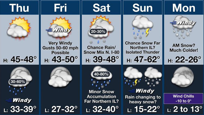
Strong to very strong winds are forecast to develop overnight Thursday to Friday and especially Friday morning to early Friday afternoon with a potential for 60 mph wind gusts. Peak winds are likely to hit from 9:00 a.m. to 12:00 p.m. Friday, March 13, 2026. Wind Advisories and High Wind Watches were issued for Chicagoland. A High Wind Warning was issued at 11:28 AM Thursday March 12, 2026.
HIGH WIND WARNING
Action Required: Take immediate precautions, such as securing loose outdoor objects, staying away from windows, and exercising caution while driving.
Criteria: Generally, sustained winds of 40 mph or gusts 58 mph (50+ mph in mountain locations).
Driving Safety: High-profile vehicles should avoid travel, and drivers should keep both hands on the wheel and slow down.
Dangers and Hazards: Damaging winds can blow down tree limbs and power lines. Neighborhood and widespread power outages are possible. Avoid windows during the windstorms. Watch for falling debris and tree limbs. Use extra caution if you must drive.
There is a small potential for snow/graupel squalls with a cold front late Friday tonight, mainly across far northern Illinois.
A strong storm system may bring a threat for strong storms to the region on Sunday, followed by accumulating snow and another round of very strong winds Sunday night into Monday. Snow periods in the forecast are indicated for Saturday 6:00 p.m. to Sunday 6:00 a.m. and for Sunday 7:00 p.m. to Monday 6:00 a.m.
The air temperature forecast is indicating much colder temperatures beginning Monday March 16, 2026 at about 4:00 a.m. with air temperature down to 22°F with 5°F wind chill, and Tuesday 6:00 a.m. down to 11°F with -1°F wind chill.
Weather Radar at 10:30 a.m. Thursday March 12, 2026 in northeast Illinois was clear. The satellite view indicates clear skies for the entire state of Illinois at 10:30 a.m.
See also Arlingtoncardinal.com/clouds
Very windy conditions are expected tonight into Fri with gusts 50-60 mph expected. Periods of rain and a chance of thunderstorms are expected Sunday. Some of these storms may be strong. The rain will change to snow Sunday night with some heavy snow accumulation possible. #ILWX #INWX pic.twitter.com/5Yf3Kv85j4
— NWS Chicago (@NWSChicago) March 12, 2026
O’HARE FORECAST …
High Wind Watch Upgraded to High Wind Warning at 11:28 AM Thursday …
High Wind Watch in effect from March 13, 04:00 AM CDT until March 13, 04:00 PM CDT
High Wind Warning in effect from March 13, 01:00 AM CDT until March 13, 04:00 PM CDT
Thursday: Increasing clouds, with a high near 47. West northwest wind around 10 mph becoming southwest in the afternoon. Winds could gust as high as 20 mph.
Thursday Night: Showers likely, mainly between 2am and 5am. Mostly cloudy, with a low around 36. Windy, with a south wind 15 to 20 mph increasing to 25 to 30 mph after midnight. Winds could gust as high as 45 mph. Chance of precipitation is 60%. New precipitation amounts of less than a tenth of an inch possible.
Friday: Mostly cloudy, with a high near 45. Very windy, with a west wind 30 to 35 mph, with gusts as high as 55 mph.
Friday Night: Mostly cloudy, with a low around 31. Northwest wind 10 to 15 mph decreasing to 5 to 10 mph after midnight. Winds could gust as high as 35 mph.
Saturday: A slight chance of snow showers after 1pm, mixing with rain after 4pm. Cloudy, with a high near 42. North wind around 5 mph becoming east southeast in the afternoon. Winds could gust as high as 10 mph. Chance of precipitation is 20%.
Saturday Night: Rain and snow showers likely, mainly after 1am. Cloudy, with a low around 35. Chance of precipitation is 70%.
Sunday: Showers, with thunderstorms also possible after 1pm. High near 52. Chance of precipitation is 100%.
Sunday Night: Rain and snow showers, becoming all snow after 1am. Cloudy, with a low around 20. Blustery.
Monday: A chance of snow before 1pm. Mostly cloudy, with a high near 26. Blustery.
Monday Night: Partly cloudy, with a low around 9.
Tuesday: Mostly sunny, with a high near 27.
Tuesday Night: Mostly cloudy, with a low around 18.
Wednesday: Mostly cloudy, with a high near 40.
LAKE TEMPS …
Southern Lake Michigan Water Temperatures
National Weather Service Chicago/Romeoville IL
907 AM CDT Thu Mar 12 2026
Lake Michigan Water Temperatures…
Chicago Shore………..40.
Chicago Crib…………42.
Michigan City………..40.
South Mid Lake Buoy…..38.
&&
M is for missing data that is normally available. Chicago Shore, Chicago Crib, and Michigan City are read every day of the year.
Measured at a depth of 60 ft for Chicago Crib and 30 ft for Michigan City. May not represent surface temperature.
march.chicagoweatherstation.com
Chicago Weather Forecast for your MAC/PC/TABLET includes surrounding suburbs.
^^ MOBILE? USE VOICE MIC ^^
facebook …
Please ‘LIKE’ the ‘Arlington Cardinal Page. See all of The Cardinal Facebook fan pages at Arlingtoncardinal.com/about/facebook …
Help fund The Cardinal Arlingtoncardinal.com/sponsor
