
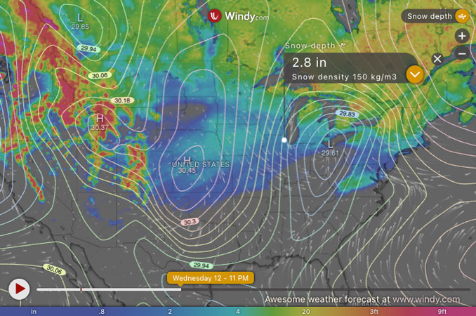
According to the NWS Chicago, the snowfall totals for Wednesday’s storm are uncertain. Models/forecasts including the Arlington Heights area are indicating a range, including a 2.8″ total, a 4″ total or a 5″ total. CARDINAL NEWS is choosing a prediction of 2″ to 4″ range for total snowfall from Wednesday morning to midnight Wednesday/Thursday for the Arlington Heights area.
A Winter Storm Watch for Wednesday that was activated early Monday afternoon, February 10, 2025 was updated (downgraded) to a Winter Weather Advisory Tuesday morning in Chicagoland. As of late Tuesday morning there are no counties in Chicagoland under a Winter Storm Watch. However, a Winter Storm Warning was activated Tuesday in western Illinois around the Peoria area and south. A Winter Storm Watch was activated Tuesday in northwest Illinois west of Rockford, and in southern Wisconsin.
According to NWS Chicago, the weather situation regarding precipitation amounts that had looked to be borderline high-end Winter Weather Advisory/low-end Winter Storm Warning, are now looking more solidly in the Winter Weather Advisory category — associated with 3-6″ snowfall instead of a 4-8″ snowfall.
There might be some snow flurries and light snow beginning around 3:00 p.m. Tuesday but the real snow probably won’t start until about 2:00 a.m. or 3:00 a.m. Wednesday, February 12, 2025. The most intense snow is expected between 10:00 a.m. and 8:00 p.m. Wednesday. NWS Chicago didn’t indicate the expected snow-to-water ratio for this first significant winter storm of the season, but Low Pressure is digging in (behind schedule) at the Four Corners in the southwest United States. This “Texas Panhandle Hook” pattern typically brings heavier, wet snow. The air temperature is expected to be about 28-29°F during the highest snowfall rates 10:00 a.m. and 8:00 p.m. Wednesday.
A cold front moved across the Chicago Tuesday morning with a very slight dusting of snow, turning winds to the northeast with gusts into the 20 mph range. Temps in the lower 20s north to upper 20s south probably won’t recover much for highs Tuesday. On Wednesday, the ground will be cold and ready to accept snow accumulation as soon as the snow starts falling. The February 11 normal high for Chicago at O’Hare is 34°F with a low of 19°F.
Here’s the Tuesday, February 11, 2025 (2:00 PM) snowfall outlook for Wednesday. The ECMWF model is indicating only about 2.8 inches total snowfall for Arlington Heights by Wednesday/Thursday at midnight. The GFS model is indicating about 4 inches total. The NWS Chicago graph forecast is indicating a snowfall total of about 5 inches by midnight Wednesday/Thursday.
ECMWF model is the European Centre for Medium-Range Weather Forecasts model.
GFS model is the Global Forecast System model run by the United States.
Weather Radar at 2:00 p.m. in northeast Illinois and the rest of Illinois was clear.
See also Arlingtoncardinal.com/clouds
A winter storm will bring accumulating snow to the region Wednesday and Wednesday night, and will significantly impact the Wednesday PM commute. Colder weather late in the week, with another winter storm possible late Fri-Sat. #ILwx #INwx pic.twitter.com/MTm20JdnLZ
— NWS Chicago (@NWSChicago) February 11, 2025
O’HARE FORECAST …
Winter Weather Advisory
URGENT – WINTER WEATHER MESSAGE
National Weather Service Chicago IL
1141 AM CST Tue Feb 11 2025
Winnebago-Boone-McHenry-Lake IL-Ogle-Lee-De Kalb-Kane-DuPage-La Salle-Kendall-Grundy-Kankakee-Livingston-Northern Cook-Central Cook-Southern Cook-Northern Will-Southern Will-Eastern Will-Lake IN-Porter- Including the cities of Peotone, Algonquin, Coal City, Cicero, La Salle, Plano, Elgin, Fairbury, Aurora, Oswego, Kankakee, Mundelein, Portage, Minooka, Gurnee, La Grange, Orland Park, Wheaton, Mokena, Palatine, Oak Park, Buffalo Grove, DeKalb, Schaumburg, Oak Lawn, Channahon, Dixon, Waukegan, Hammond, Calumet City, Morris, Oak Forest, Gary, Yorkville, Park Forest, Wilmington, Ottawa, Valparaiso, Chesterton, McHenry, Lemont, Bolingbrook, Streator, Mendota, Woodstock, Rockford, Evanston, Oregon, Downers Grove, Carol Stream, Sycamore, Marseilles, Bradley, Plainfield, Crete, Beecher, Bourbonnais, Crystal Lake, Manhattan, Rochelle, Des Plaines, Lombard, Pontiac, Joliet, Merrillville, Northbrook, Dwight, Chicago, Naperville, Belvidere, and Byron 1141 AM CST Tue Feb 11 2025
…WINTER WEATHER ADVISORY IN EFFECT FROM 9 AM WEDNESDAY TO 3 AM CST THURSDAY…
* WHAT…Snow, possibly heavy at times, expected. Total snow accumulations between 3 and 6 inches.
* WHERE…Portions of central, north central, and northeast Illinois and northwest Indiana.
* WHEN…From 9 AM Wednesday to 3 AM CST Thursday.
* IMPACTS…Travel could be very difficult, including during the Wednesday evening commute.
PRECAUTIONARY/PREPAREDNESS ACTIONS…
Slow down and use caution while traveling. The latest road conditions for Illinois can be obtained at www.gettingaroundillinois.com. The latest road conditions for Indiana can be obtained at https://511in.org.
7-DAY FORECAST
Tuesday Afternoon: A chance of flurries. Cloudy, with a high near 26. North northeast wind around 10 mph, with gusts as high as 15 mph.
Tuesday Night: A chance of flurries before 1am, then snow likely, mainly after 5am. Cloudy, with a low around 22. Northeast wind around 10 mph, with gusts as high as 20 mph. Chance of precipitation is 60%. New snow accumulation of less than a half inch possible.
Wednesday: Snow. High near 29. East northeast wind 10 to 15 mph, with gusts as high as 20 mph. Chance of precipitation is 100%. New snow accumulation of 3 to 5 inches possible.
Wednesday Night: Snow and freezing rain before midnight, then a chance of snow between midnight and 2am. Low around 16. Northeast wind 10 to 15 mph becoming northwest after midnight. Chance of precipitation is 90%. Little or no ice accumulation expected. New snow accumulation of 1 to 2 inches possible.
Thursday: Mostly sunny, with a high near 20. West wind 10 to 15 mph, with gusts as high as 20 mph.
Thursday Night: Mostly clear, with a low around 2.
Friday: A 40 percent chance of snow after noon. Mostly cloudy, with a high near 29.
Friday Night: Snow. Cloudy, with a low around 24.
Saturday: Snow likely. Cloudy, with a high near 34.
Saturday Night: A chance of snow. Mostly cloudy, with a low around 10.
Sunday: Partly sunny, with a high near 17.
Sunday Night: Partly cloudy, with a low around -2.
Washington’s Birthday (Monday): A chance of snow. Partly sunny, with a high near 14.
LAKE TEMPS …
SOUTHERN LAKE MICHIGAN WATER TEMPERATURES
NATIONAL WEATHER SERVICE CHICAGO/ROMEOVILLE IL
904 AM CST Tue Feb 11 2025
LAKE MICHIGAN WATER TEMPERATURES…
CHICAGO SHORE………..32.
CHICAGO CRIB…………33.
MICHIGAN CITY………..33.
SOUTH MID LAKE BUOY…..39.
&&
M IS FOR MISSING DATA THAT IS NORMALLY AVAILABLE.
THE MICHIGAN CITY WATER TEMPERATURE SENSOR IS LOCATED AT
A WATER INTAKE ONE MILE OFFSHORE AND 60 FEET BELOW THE
WATER SURFACE. IT IS READ EVERY DAY OF THE YEAR.
february.chicagoweatherstation.com
Chicago Weather Forecast for your MAC/PC/TABLET includes surrounding suburbs.
^^ MOBILE? USE VOICE MIC ^^
facebook …
Please ‘LIKE’ the ‘Arlington Cardinal Page. See all of The Cardinal Facebook fan pages at Arlingtoncardinal.com/about/facebook …
Help fund The Cardinal Arlingtoncardinal.com/sponsor
