

A Severe Thunderstorm Watch that was activated Monday until 5:00 p.m. has been canceled early for many counties, but remained in effect for Lake County, McHenry County, Kane County and some counties in southeast Wisconsin.
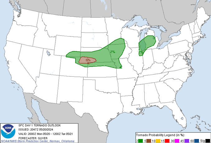
There was no Severe Thunderstorm Watch for Cook County, DuPage County or Will County on Monday, but the NWS Storm Prediction Center had Arlington Heights and the northwest suburbs in a small zone at a 2% risk of a tornado within 25 mile inside the zone. Some areas north and west of the northwest suburbs were at a 5% percent risk. The risks continue until 5:00 a.m. CDT Tuesday in an update issued at 3:47 p.m. CDT.
A few power failures, and lightning strikes occurred in the northwest suburbs, but there were no significant fires or damage reports. A steel frame collapsed in Machesney Park at a construction project on Alpine Road, but initially a cause for the collapse has not been indicated.
A Mesoscale Convective Vortex (MCV) or thunderstorm complex was centered near Madison, Wisconsin Monday afternoon, pinwheeling multiple arcs of convection across northern Illinois. While the thermodynamic and kinematic set-up continued to support organized severe convection, it appeared conditions were not sufficiently contributing to low-level convergence for maintaining larger thunderstorm cores. There were some thunderstorm cells producing sub-severe hail and wind, so the National Weather Service upheld the possibility that strong to severe cores could occur until about 4-5pm — but these storms were more likely north and west of Arlington Heights.
Weather Radar showed thin bands of thunderstorms moving northeast almost along the direction of the line of storms. In other words, storm movement was not perpendicular to the advancing line of thunderstorms — possibly a characteristic of pinwheeling off the MCV near Madison, Wisconsin.
Precipitation was diminishing in northern Illinois after 2:30 p.m.
Small cells were popping up before noon with brief rain periods that were earlier than expected Monday. By 1:30 p.m. there were four lines of storms in northeast Illinois, moving northeast.
Satellite views showed clouds blowing up consistent with radar, but then clearing in northwestern and western Illinois.
See also Arlingtoncardinal.com/clouds
Thunderstorms may not have been as severe as initially forecast because mostly cloudy conditions may have prevented surface heating for convection — the vertical transport of heat and moisture that strengthens thunderstorms. Temperatures west of the Fox River were only in the low 70s, and most temperatures in McHenry County were also in the low 70s. Temperatures in Lake County were mostly in the 70s, except south near Lincolnshire and Buffalo Grove.
Central Illinois, including Champaign was in the mid-80s. Where rain occurred in the northwest suburbs, some areas were only in the upper 60s, but later rebounded back up into the 70s.
Additional precipitation Monday night is not likely to result in severe weather. However, some rain may return about 5:00 p.m. or later.
https://x.com/NWSChicago/status/1792618157548646849
https://x.com/NWSChicago/status/1792610786466214331
https://x.com/NWSChicago/status/1792505718291284023
O’HARE FORECAST …
Monday Afternoon: A 50 percent chance of showers and thunderstorms. Mostly cloudy, with a high near 85. Breezy, with a southwest wind around 20 mph, with gusts as high as 30 mph.
Monday Night: A 40 percent chance of showers and thunderstorms, mainly before 1am. Mostly cloudy, with a low around 65. West wind 5 to 15 mph becoming east after midnight. Winds could gust as high as 20 mph. UPDATE: A 30 percent chance of showers and thunderstorms, mainly after 9pm. Mostly cloudy, with a low around 65. West wind 5 to 15 mph becoming east after midnight. Winds could gust as high as 20 mph.
Tuesday: A 30 percent chance of showers and thunderstorms, mainly before 1pm. Mostly sunny, with a high near 88. Breezy, with a southeast wind 5 to 10 mph increasing to 15 to 20 mph in the afternoon. Winds could gust as high as 35 mph.
Tuesday Night: Showers and thunderstorms likely, mainly between 10pm and 1am. Mostly cloudy, with a low around 65. Breezy, with a south wind 15 to 20 mph, with gusts as high as 30 mph. Chance of precipitation is 70%.
Wednesday: Mostly sunny, with a high near 77. West southwest wind around 15 mph, with gusts as high as 25 mph.
Wednesday Night: Mostly clear, with a low around 56.
Thursday: Sunny, with a high near 77.
Thursday Night: Mostly clear, with a low around 56.
Friday: A chance of showers after 1pm. Mostly sunny, with a high near 75.
Friday Night: A chance of showers. Partly cloudy, with a low around 58.
Saturday: A chance of showers and thunderstorms. Partly sunny, with a high near 77.
Saturday Night: A chance of showers and thunderstorms. Partly cloudy, with a low around 59.
Sunday: A chance of showers. Mostly sunny, with a high near 77.
LAKE TEMPS …
SOUTHERN LAKE MICHIGAN WATER TEMPERATURES
NATIONAL WEATHER SERVICE CHICAGO/ROMEOVILLE IL
908 AM CDT Mon May 20 2024
LAKE MICHIGAN WATER TEMPERATURES…
CHICAGO SHORE………..60.
CHICAGO CRIB…………58.
WAUKEGAN BUOY………..58.
WINTHROP HARBOR BUOY….56.
MICHIGAN CITY………..M.
SOUTH MID LAKE BUOY…..M.
CENTRAL MID LAKE BUOY…47.
NORTH MID LAKE BUOY…..48.
&&
M IS FOR MISSING DATA THAT IS NORMALLY AVAILABLE.
THE MICHIGAN CITY WATER TEMPERATURE SENSOR IS LOCATED AT
A WATER INTAKE ONE MILE OFFSHORE AND 60 FEET BELOW THE
WATER SURFACE. IT IS READ EVERY DAY OF THE YEAR.
Chicago Weather Forecast for your MAC/PC/TABLET includes surrounding suburbs.
^^ MOBILE? USE VOICE MIC ^^
facebook …
Please ‘LIKE’ the ‘Arlington Cardinal Page. See all of The Cardinal Facebook fan pages at Arlingtoncardinal.com/about/facebook …
Help fund The Cardinal Arlingtoncardinal.com/sponsor
Area Forecast Discussion
National Weather Service Chicago/Romeoville, IL
204 PM CDT Mon May 20 2024
.KEY MESSAGES…
– Scattered t-storms likely today, a few severe storms with large hail and damaging winds possible this afternoon.
– Another round of thunderstorms is expected Tuesday evening into the nighttime hours. Severe thunderstorms with damaging winds and brief QLCS type tornadoes are possible with this round.
– Another chance for showers Friday into Saturday
&&
.MESOSCALE…
Issued at 204 PM CDT Mon May 20 2024
The MCV, now centered near Madison, continues to pinwheel multiple arcs of convection across northern Illinois this afternoon. While the thermodynamic and kinematic set-up continues to support organized severe convection, it appears low-level veering nearly parallel to the main forcing axes this far south is not sufficiently contributing to low-level convergence for maintaining larger cores. There have continued to be several attempts at cells producing sub- severe hail and wind, so have not dismissed the fact that some strong to severe cores will remain possible through the remainder of the Chicago metro through 4-5pm.
Kluber
Issued at 1052 AM CDT Mon May 20 2024
The warm front has now moved/mixed northward to near the I-88 corridor and across Chicago (12F temp spread at ORD/MDW). Recent mesoanalysis indicates that areas south of the warm front have generally become uncapped with MLCAPE values nearing 2000 J/kg. Meanwhile, effective shear profiles are becoming more favorable ahead of the MCV across the western CWA. The first area of interest noted earlier has spurred a renewed axis of mainly elevated convection, though some of the southern cells are attempting to become surface based near the warm front. While this axis appears to continue to outrun the better environment, the proximity of the warm front and increasing potential for surface-based convection supports isolated severe storms with a non-zero brief tornado risk over the next hour or two into far northeast Illinois.
As for the second area to the southwest, we continue to keep a close eye on the potential for convection to erupt in and around the Peoria area over the next hour or so. So while convection is slower to materialize than previously expected in this area, it remains a favored area of a growing cluster of severe convection into the Chicago metro 2-4pm.
Kluber
Issued at 806 AM CDT Mon May 20 2024
We continue to assess the impacts from a compact MCV over southern Iowa (originating from a complex of convection over Kansas last evening). While the low-level environment remains stable this morning with the warm front still south of I-80 as of 8am, the shallow nature of the front combined with 25-30 knot winds above the frontal surface and abundant sunshine will allow the front to mix/jump north across most of northern Illinois over the next 2-3 hours. This will result in a quick destabilization ahead of two areas of interest, one with a broken line of showers and storms fr
^^ MOBILE? USE VOICE MIC ^^
facebook …
Please ‘LIKE’ the ‘Arlington Cardinal Page. See all of The Cardinal Facebook fan pages at Arlingtoncardinal.com/about/facebook …
Help fund The Cardinal Arlingtoncardinal.com/sponsor
THANKS FOR READING CARDINAL NEWSm around the Quad Cities northward, and another with an area of agitated cloud cover crossing the Mississippi River from around Keokuk to Quincy. While the first will likely clip the western CWA through mid- morning, destabilization may not occur early enough for surface- based convection. However, we are honing in on the second area for elevated convective initiation over the next hour or two. This convection should eventually become surface- based while nearing/over the far southwest CWA by around 11am. With a locally enhanced mid-level speed max associated with the MCV, the resultant effective shear combined with an increasingly favorable thermodynamic environment may support a cluster of severe convection through the central CWA into the Chicago metro between 11am-2pm. Primary hazards will be damaging wind and large hail, but a brief tornado cannot be ruled out with any boundary interactions and marginally favorable 0-1km wind profiles.
Kluber
&&
.DISCUSSION… Issued at 325 AM CDT Mon May 20 2024
Today and tonight:
A pair of MCVs will likely be the significant players in our weather today. MCV #1 located over northeast IA as of 07z will continue to move northeastward and generally away from the area this morning. A north-south line of convection extending south of this vort across eastern IA should begin a weakening phase in the next couple of hours as it progresses east-northeast into a more stable air mass. Nonetheless, some showers and perhaps a t-storm could affect our western and northwestern CWA early this morning in association with this feature before dissipating and/or moving north into WI by mid morning. Severe wx with this activity is unlikely.
MCV #2 should be the more problematic feature today. Currently over northwest Missouri, hi-res model guidance matches well with simple extrapolation, both have this features moving into southwest WI early this afternoon. A formidable mid level jet accompanies this feature with the latest VWP from KEAX showing 50-55kt winds from 700-500mb. While this MCV will probably weaken some this morning given the waning convective activity, the RAP (which seems to have initialized this feature pretty well when compared with observational data) maintains a 40-50kt 700mb jetlet and 35-45kt at 500mb into the early/mid afternoon on the southeastern flanks of this MCV across far northern IL into southern WI.
This stronger flow with the vort max results in some respectable low-mid level hodographs for a time late this morning through early-mid afternoon. While 0-6km bulk shear is only progged to be around 30kt, almost all of the shear will be focused in the 0-3km layer where hodographs are somewhat elongated and a bit curved. Ongoing convection with MCV #2 is expected to weaken/dissipate this morning and likely allow for at least some mixed sunshine to heat the moistening boundary layer as warm front lifts north across the CWA this morning. Assuming convective debris isn`t more extensive than expected, then MLCAPE of around 2000 J/kg could be realized by early afternoon with minimal inhibition left. Assuming convection develops over northern IL this afternoon, and that looks pretty likely, the next question will be how soon. If robust convection can develop by early afternoon, favorable shear profiles will be in place to support an storm scale organization and including maybe some messy supercell structures. Given the shear maximized in the low levels with largely streamwise vorticity in the 0-1km layer, there could even be a couple hour window with some low end tornado threat. This would particularly be near the northward retreating warm front and assuming robust convection develops early enough to reap the benefits of the stronger mid- level flow associated with the MCV.
Heading into the mid and especially late afternoon, shear profiles will quickly weaken and hodographs collapse in on themselves. This means our severe threat should become relegated to mainly a pulse type severe threat with accompanying brief marginal hail and localized microburst where any updrafts find some untapped CAPE to feed on. Thunderstorms should dissipate and then end this evening as the MCV lifts north out of the area and the boundary stabilizes. Maintained some slight chance pops late this evening and overnight as a nod to the RAP which has another MCV and associated convective complex rolling across the area. Not seeing any evidence of this feature upstream now and this scenario seems unlikely, with most likely scenario being mostly dry conditions tonight.
