
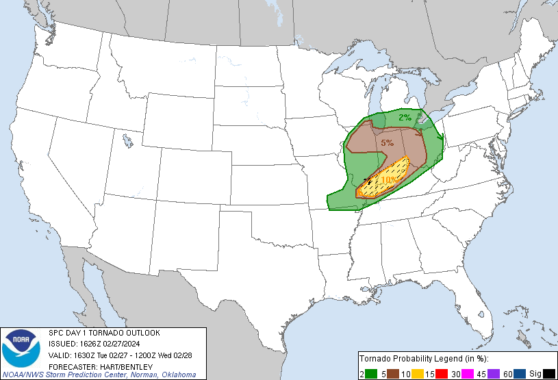
West, central, northwest, and north Chicagoland is in an area of enhanced risk of severe thunderstorms and a possible tornado, according to the National Weather Service Storm Prediction Center.
All of Chicagoland is in a risk area of 5% or greater probability of EF2 – EF5 tornadoes within 25 miles of any point in the Chicagoland area. The 5% risk area in Chicagoland and beyond (totaling seven states) affects 21,797,018 people.
The strongest risk for tornadoes is in far southern Illinois, southern Indiana, far southeast Missouri, and southwest Ohio, where there is a risk area of 10% or greater probability of EF2 – EF5 tornadoes within 25 miles of any point — affecting 3,248,751 people.
WEATHER HIGHLIGHTS …
Tuesday, February 27, 2024 will likely be the warmest February and meteorological winter day ever recorded in our area
Thunderstorms, possibly severe with tornadoes, will probably impact at least portions of the Chicagoland forecast area Tuesday evening
A “powerhouse cold front” will rip across Chicagoland late Tuesday evening with a truly mind-boggling apparent temperature drop of 60-75 degrees in less than 12 hours (77°F at 3PM down to 20°F at 8 AM)
Chance (40-60%) for quick hitting accumulating snow late tonight with threat of hazardous travel (0.4 inch possible in Arlington Heights 3AM to 5AM)
Briefly turning sharply colder Wednesday into early Thursday before another likely significant warm-up into the weekend
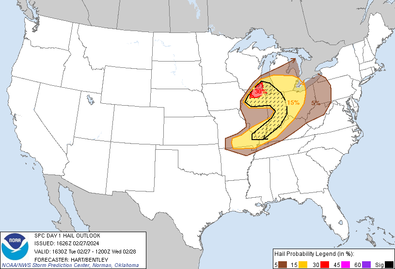
HAIL …
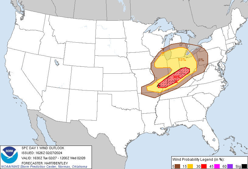
WIND …
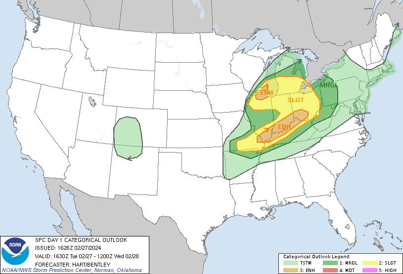
Severe thunderstorms, associated with large hail, damaging gusts, and tornadoes, some of which may be significant, will be possible from late this afternoon into the overnight, across portions of the Ohio Valley and southern Great Lakes.
A compact surface low is forecast to deepen across eastern Iowa this afternoon, with a narrow warm sector pulling northward into much of northern Illinois. Strong forcing near the low and along the associated warm front will lead to intense thunderstorms across portions of northern IL after 6:00 p.m.
The highest risk period of severe thunderstorms and tornadoes is between 6:00 p.m. and 11:00 p.m. Tuesday, February 27, 2024.
Forecast soundings show steep low and mid level lapse rates and sufficient CAPE (Convective Available Potential Energy), along with strong low and deep layer shear profiles. The weather conditions Tuesday evening will be conducive to supercell structures capable of very large hail and damaging winds.
There remains uncertainty whether these storms will be in the warm-sector, or will be undercut by nearby cold air. The NWS upgraded an enhanced risk for hail in northeast Illinois, north central Illinois and southeast Wisconsin.
Weather Radar in northeast Illinois was clear at 11:45 a.m.
See also Arlingtoncardinal.com/clouds
Cloud cover is forecast to be less than 60% before 3:00 p.m. when advanced storm clouds begin to move in the area.
Today is forecast to be the warmest day ever record during February or meteorological winter with highs in the 70s! Strong cold front tonight will bring a threat of severe t-storms, then snow, wind, and bitter cold. Temps will rebound to spring-like levels by the weekend! pic.twitter.com/HoLo6vPPeb
— NWS Chicago (@NWSChicago) February 27, 2024
O’HARE FORECAST …
Tuesday Afternoon: Partly sunny, with a high near 75. South southwest wind 10 to 15 mph, with gusts as high as 25 mph.
Tonight: Rain showers likely before 3am, then snow showers likely, possibly mixed with rain between 3am and 4am, then snow showers likely after 4am. Some thunder is also possible. Mostly cloudy, with a low around 20. Windy, with a south wind 10 to 20 mph becoming northwest 20 to 30 mph after midnight. Winds could gust as high as 45 mph. Chance of precipitation is 60%. New snow accumulation of less than a half inch possible.
Wednesday: A 20 percent chance of snow showers before 9am. Cloudy through mid morning, then gradual clearing, with a high near 28. Wind chill values as low as 1. Blustery, with a northwest wind 20 to 25 mph, with gusts as high as 40 mph.
Wednesday Night: Clear, with a low around 17. West northwest wind 5 to 15 mph, with gusts as high as 25 mph.
Thursday: Sunny, with a high near 44. Breezy, with a south southwest wind 5 to 10 mph increasing to 15 to 20 mph in the afternoon. Winds could gust as high as 25 mph.
Thursday Night: Mostly clear, with a low around 33. Breezy.
Friday: Partly sunny, with a high near 50. Breezy.
Friday Night: Partly cloudy, with a low around 41. Breezy.
Saturday: Sunny, with a high near 64.
Saturday Night: Partly cloudy, with a low around 50.
Sunday: Mostly sunny, with a high near 70. Breezy.
Sunday Night: A chance of showers. Partly cloudy, with a low around 56. Breezy.
Monday: Showers likely. Partly sunny, with a high near 68. Breezy.
CATEGORICAL …
LAKE TEMPS …
SOUTHERN LAKE MICHIGAN WATER TEMPERATURES
NATIONAL WEATHER SERVICE CHICAGO/ROMEOVILLE IL
901 AM CST Tue Feb 27 2024
LAKE MICHIGAN WATER TEMPERATURES…
CHICAGO SHORE………..40.
CHICAGO CRIB…………37.
MICHIGAN CITY………..38.
SOUTH MID LAKE BUOY…..40.
&&
M IS FOR MISSING DATA THAT IS NORMALLY AVAILABLE.
THE MICHIGAN CITY WATER TEMPERATURE SENSOR IS LOCATED AT
A WATER INTAKE ONE MILE OFFSHORE AND 60 FEET BELOW THE
WATER SURFACE. IT IS READ EVERY DAY OF THE YEAR.
february.chicagoweatherstation.com
Chicago Weather Forecast for your MAC/PC/TABLET includes surrounding suburbs.
^^ MOBILE? USE VOICE MIC ^^
facebook …
Please ‘LIKE’ the ‘Arlington Cardinal Page. See all of The Cardinal Facebook fan pages at Arlingtoncardinal.com/about/facebook …
Help fund The Cardinal Arlingtoncardinal.com/sponsor
AREA FORECAST DISCUSSION …
National Weather Service Chicago/Romeoville, IL 1131 AM CST Tue Feb 27 2024
.UPDATE… Issued at 1028 AM CST Tue Feb 27 2024
As of around 9 AM, a mature low pressure system is spinning over Minnesota bringing blizzard conditions to northern portions of the state. Farther south over northwest Missouri, a secondary surface low is taking shape along the storm`s cold front. Wind obs also suggest that a warm front may be trying to develop east of the low extending toward the river. This secondary low is our primary feature of interest for severe convection later today.
Some unexpected low clouds and fog across interior parts of the CWA have kept a chunk of the area cooler and with higher dewpoints this morning than previously forecast. However, it looks as though values are leveling out with the forecast as conditions clear up. Otherwise, the forecast for today remains in good shape. Additional low clouds tucked beneath a capping inversion are spreading northward over the southern half of the CWA. We see instability building atop this inversion with latest RAP guidance suggesting as much as 1,500 J/kg of MUCAPE have built up in our south. Instability will continue to build across the area through the day, although will remain capped to surface-based convection through at least 3-4 pm.
Guidance is in good agreement that the low will track right through the heart of the CWA. Strong convergence near the low pressure center puts areas near the track at the seemingly highest risk for severe convection. Namely, this would likely mean the I-80 corridor and points north. Hail remains the primary concern owing to large instability, terribly steep mid level lapse rates, and strong low-level inflow and 50+ knots of effective deep shear, though damaging wind is a secondary concern as well. The tornado threat is largely conditional on whether storms can beat out the reinforcement of the cap with nocturnal cooling and go surface based. It`ll be a tight window of opportunity, but late afternoon (from the time of CI) through around 6-8 PM looks like the best bet.
In our south and southeast, confidence is rebounding, in some aspects at least, with the severe potential. A key feature that we`ll be eyeing in this corridor is this pseudo dryline feature that could aid in parcels punching through the cap and firing up surface based convection. This would also enhance the tornado risk, but again the potential lies in a seemingly narrow window early this evening. Recent model soundings are resolving weaker and weaker capping later today. The HRRR actually just recently reintroduced convection in our south this evening with its 14Z run. We`ll have to keep a close eye on obs and CAM soundings as the low approaches and this environment comes together.
Doom/NWS Chicago
&&
.DISCUSSION… Issued at 238 AM CST Tue Feb 27 2024
Tuesday:
It will feel more like June than February, in fact there are frequently days in June that aren`t as warm as today will be! Once again Monday, temperatures exceeded the warmest available guidance and that will likely be the case again today. The boundary layer will not be as dry as Monday, however temperatures will be starting more than 20 degrees warmer than Monday morning. There will be a gradual increase in mostly high cloudiness today, but it looks like the morning into the early afternoon should see plenty of sunshine. Given 925mb temps are progged to be 2-3C warmer than Monday, a good starting point for highs today would be about 4-6F warmer than Monday. This is close to the NBM 90th percentile which has been consistently too low. Going to run with those temps which is mid-upper 70s across the CWA, which would also be the warmest February and winter day ever recorded.
An impressive elevated mixed layer over the region should provide a stout capping inversion. It looks increasingly likely that convection will be hard pressed to develop prior to 00z. Have maintained some small PoPs over the southern CWA in advance of a dry line in the 22-00z time frame, but stronger forcing doesn`t arrive until this evening, so it seems like the cap will hold.
Tuesday Night-Wednesday:
A meteorologically fascinating 12 hour period of weather is set to unfold across our region tonight. There remains a unusually large spread in guidance regarding where, when, and even if convection will develop. It appears that a bulging dryline will be surging across areas roughly south of I-80, with a relatively moist warm sector arcing back west across northern IL toward a triple point over northwest IL. Strong synoptic ascent ahead of the advancing trough along with strong convergence near the triple point seems likely to spark at least scattered thunderstorm development early this evening north of I-80 across northern IL. Some threat exists that additional storms could develop farther south along the bulging dry line. However, confidence is lower in this area as there are questions about how much moisture will survive afternoon mixing and pool ahead of the dry line and if it will be enough to allow for convective initiation as synoptic ascent begins to weaken the cap.
Instability and shear look sufficient to support supercells this evening, the question will be whether convection will be north of the warm front and clearly rooted above the boundary layer or if some storms can form in the warm sector. If there is warm sector storms, it`s unclear if they will be rooted in the boundary layer. Forecast soundings show increasing BL inhibition this evening, though it is possible that this inhibition may be overdone if low level moisture doesn`t mix out today. Ultimately, large hail looks to be the most prominent potential severe weather hazard this evening. That said, should a supercell or two become rooted in the boundary layer, then low level shear profiles suggest there would be a tornado threat during the early to mid evening hours. This is very conditional risk and we`ll be closely monitoring the evolution of the mesoscale environment through the day today.
A truly power-house cold front will come ripping across the CWA late this evening, clearing the eastern CWA not too long after midnight. This should end the severe weather threat quickly and result in temperatures crashing at a break neck pace. Hard to put this level of detail into the grids, but with a rapidly deepening surface low and very strong pressure rises behind the front, it is possible there could be a quick hit of very strong winds behind the front, with gusts potentially briefly peaking at or above 50 mph. This type of brief, intense wind burst is something that will be better handled in the “nowcast” time frame of the forecast and have not included winds of this magnitude in the grids. Even if this intense wind burst doesn`t occur, frequent gusts of 30-40 mph are expected behind the front overnight into the first half of Wednesday with at least occasional gusts to 45 mph possible. Later shifts may need to consider a Wind Advisory for at least portions of our area during this time frame.
There remains considerable spread in the guidance regarding the potential for a post frontal band of snow whisking rapidly across the area late tonight. It is going to be a very dynamic and quickly changing environment overnight, so it isn`t too surprising to see the spread in guidance. It is concerning to see models like the NAM, ARW, and HRRR squeezing out enough QPF to support an inch or two of snow for some areas. The GFS is similar, but confined to mostly our far northwestern CWA, which the ECMWF suggests any post front precip will occur before temps cool enough for snow. It`s really difficult to handle this threat in deterministic grids, so will likely try to message this threat with some probabilistic graphics this morning. Unfortunately, the difference between the 25th percentile snow amount and the 75th percentile snow accumulation is the difference between a potentially hazardous and difficult Wednesday morning commute and little or no problems. Hopefully morning guidance will come to a better consensus on the snow potential tonight.
Finally, can`t stress enough how dramatic the temperature change will be from this evening to Wednesday morning. We are literally going to go from June-like temperatures this evening to frigid January level temperatures by sunrise Wednesday morning. Have trended temps colder in the grids late tonight into Wednesday morning and am now explicitly forecast wind chills in the single digits above zero to several degrees below zero over the northwestern CWA. While skies will clear out Wednesday, it will be deceptive sunshine Wednesday as strong northwest winds and only a very modest rebound in temps will result in wind chills struggling to get any warmer than 10F above zero Wed afternoon.
– Izzi/NWS Chicago
