
…WINTER STORM WATCH IN EFFECT FROM FRIDAY MORNING THROUGH
SATURDAY MORNING… first issued at 2:18 p.m. Wednesday, January 10, 2024.
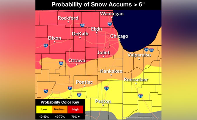
Beginning Thursday/Friday about midnight and lasting through Saturday, a major winter storm with heavy snow and strong winds is increasingly likely (40-60%+ probability of 6″+ snow and major impacts) pre-dawn Friday through Saturday morning.
Currently the area around Arlington Heights and O’Hare International Airport is forecast to get about 10 inches of snow, with most of the snow falling between 6:00 a.m. Friday and 6:00 a.m. Saturday.
The worst impacts/dangerous to life threatening travel conditions are expected after dark Friday through early Saturday, with periods of blizzard conditions possible (20-30% chance of true 3-hour blizzard criteria).
Winter Storm Watch issued for areas near and north of the Illinois and Kankakee Rivers early Friday through mid-day Saturday.
Strong onshore winds off a still mild Lake Michigan will once again likely cut into if not eliminate snow accumulations near the immediate shore during the day on Friday, including east of I-90/94 in Illinois, and north of I-80/94 in Indiana.
Additional Important Forecast/Potential Impacts Details:
Similar to previous storm, the first phase through the day on Friday will feature low ratio, heavy, wet snow with the rain/snow line spreading to near or north of the I-80 corridor and temperatures around to above 32F.
The snow ratio will become drier (12-15:1+) as temperatures quickly fall Friday night and NNW to NW winds gust to 40-50 mph, resulting in the potential for blizzard conditions as snow becomes more readily blown around atop the wet underlying snow.
Hazardous conditions with periods of snow showers and blowing snow will continue into or through the day on Saturday with temperatures in the teens-20s and wind chills of 0-10F.
Weather Radar shows the advanced edge of the disturbance in a line from Davenport, Iowa to Peoria, Illinois at about 6:00 p.m.
The Wednesday night radar images show an advancing disturbance that is a prequel to the major storm Friday and Saturday, and will only bring about 1.5 inch snow accumulation to the Arlington Heights and O’Hare International Airport area overnight Wednesday to Thursday.
The period of accumulating snow is forecast in a wide time range from 10pm-6am for Chicagoland and specifically 12am-4am for Arlington Heights and O’Hare International Airport.
The quick moving weather disturbance was over eastern Nebraska at about 3:00 p.m. Wednesday, and will continue to progress eastward toward Chicagoland Wednesday evening.
See also Arlingtoncardinal.com/clouds
Dangerous travel conditions due to accumulating and blowing snow is expected for Fri into Sat morning. The worst of the conditions will likely be late Fri afternoon thru early Sat, but uncertainty remains in storm track snow amounts. Stay updated on the forecast! #ILwx #INwx pic.twitter.com/YaIgyxAvZb
— NWS Chicago (@NWSChicago) January 10, 2024
The coldest air of the season is expected to arrive towards Sunday and into next week. The coldest wind chills during this time may fall below -20 °F at times. #ILwx #INwx pic.twitter.com/4a6TYOGNsc
— NWS Chicago (@NWSChicago) January 10, 2024
Here is a timeline of the potential winter impacts Thu night through Sun. A transition to rain or rain/snow mix is possible on Fri for areas south of I-80 before a return to fluffy snow and gusty winds occurs late Fri PM. Followed by bitter cold into next week. #ILwx #INwx pic.twitter.com/0Hyn70rvV2
— NWS Chicago (@NWSChicago) January 10, 2024
O’HARE FORECAST …
Wednesday Night: Snow, mainly after midnight. Low around 28. South wind 5 to 10 mph. Chance of precipitation is 100%. Total nighttime snow accumulation of 1 to 2 inches possible.
Thursday: Mostly cloudy, with a temperature falling to around 28 by 5pm. West wind 5 to 15 mph, with gusts as high as 20 mph.
Thursday Night: Snow likely, mainly after 3am. Cloudy, with a temperature rising to around 32 by 5am. Southwest wind 5 to 15 mph becoming east after midnight. Winds could gust as high as 20 mph. Chance of precipitation is 60%. New snow accumulation of less than a half inch possible.
Friday: Snow before 9am, then snow, possibly mixed with rain between 9am and 3pm, then snow after 3pm. The snow could be heavy at times. Patchy blowing snow between noon and 5pm. High near 34. Breezy, with an east wind 15 to 20 mph, with gusts as high as 30 mph. Chance of precipitation is 100%. New snow accumulation of 4 to 8 inches possible.
Friday Night: Snow. The snow could be heavy at times. Widespread blowing snow, mainly after 3am. Low around 21. Windy, with a northeast wind 15 to 20 mph becoming northwest 25 to 30 mph in the evening. Winds could gust as high as 45 mph. Chance of precipitation is 100%.
Saturday: Snow likely. Areas of blowing snow before noon. Mostly cloudy, with a high near 23. Windy. Chance of precipitation is 60%.
Saturday Night: A 40 percent chance of snow. Mostly cloudy, with a low around -2. Breezy.
Sunday: A chance of snow after noon. Mostly cloudy and cold, with a high near 7.
Sunday Night: Mostly cloudy, with a low around -11.
M.L.King Day – Monday: Partly sunny and cold, with a high near 2.
Monday Night: Mostly cloudy, with a low around -7.
Tuesday: Partly sunny and cold, with a high near 6. Breezy.
Tuesday Night: Mostly cloudy, with a low around -1. Breezy.
Wednesday: Partly sunny, with a high near 12.
LAKE TEMPS …
SOUTHERN LAKE MICHIGAN WATER TEMPERATURES
NATIONAL WEATHER SERVICE CHICAGO/ROMEOVILLE IL
911 AM CST Wed Jan 10 2024
LAKE MICHIGAN WATER TEMPERATURES…
CHICAGO SHORE………..37.
CHICAGO CRIB…………39.
MICHIGAN CITY………..39.
SOUTH MID LAKE BUOY…..42.
&&
THE MICHIGAN CITY WATER TEMPERATURE SENSOR IS LOCATED AT A WATER INTAKE ONE MILE OFFSHORE AND 60 FEET BELOW THE WATER SURFACE. IT IS READ EVERY DAY OF THE YEAR.
january.chicagoweatherstation.com
Chicago Weather Forecast for your MAC/PC/TABLET includes surrounding suburbs.
^^ MOBILE? USE VOICE MIC ^^
facebook …
Please ‘LIKE’ the ‘Arlington Cardinal Page. See all of The Cardinal Facebook fan pages at Arlingtoncardinal.com/about/facebook …
Help fund The Cardinal Arlingtoncardinal.com/sponsor
WINTER STORM WATCH …
URGENT – WINTER WEATHER MESSAGE
National Weather Service Chicago IL
218 PM CST Wed Jan 10 2024
ILZ005-006-012-013-023-103>108-INZ001-002-110430- /O.NEW.KLOT.WS.A.0002.240112T1200Z-240113T1800Z/ McHenry-Lake IL-Kane-DuPage-Kankakee-Northern Cook-Central Cook- Southern Cook-Northern Will-Southern Will-Eastern Will-Lake IN- Porter- Including the cities of Crystal Lake, Algonquin, McHenry, Woodstock, Waukegan, Buffalo Grove, Mundelein, Gurnee, Aurora, Elgin, Naperville, Wheaton, Downers Grove, Lombard, Carol Stream, Kankakee, Bourbonnais, Bradley, Evanston, Des Plaines, Schaumburg, Palatine, Northbrook, Chicago, Cicero, Oak Lawn, Oak Park, La Grange, Calumet City, Oak Forest, Lemont, Orland Park, Park Forest, Joliet, Bolingbrook, Plainfield, Mokena, Channahon, Manhattan, Wilmington, Crete, Peotone, Beecher, Gary, Hammond, Merrillville, Portage, Valparaiso, and Chesterton 218 PM CST Wed Jan 10 2024
…WINTER STORM WATCH IN EFFECT FROM FRIDAY MORNING THROUGH SATURDAY MORNING…
* WHAT…Heavy snow and blowing snow possible. Total snow accumulations greater than 6 inches possible. Winds could gust as high as 45 to 50 mph.
* WHERE…Portions of northeast Illinois and northwest Indiana.
* WHEN…From Friday morning through Saturday morning.
* IMPACTS…Travel could be dangerous. Areas of blowing snow could significantly reduce visibility. The hazardous conditions will likely impact both Friday commutes. Gusty winds could bring down tree branches.
* ADDITIONAL DETAILS…The strongest winds with the potential for periods of blizzard conditions are expected Friday evening into early Saturday. Warmer temperatures near Lake Michigan will likely cut into snow accumulations during the day on Friday.
PRECAUTIONARY/PREPAREDNESS ACTIONS…
Monitor the latest forecasts for updates on this situation.
&&
$$
Castro
