
The McHenry city forecast for total snowfall has increased from 7.5 inches to 8.9 inches.
The Arlington Heights forecast for total snowfall has increased from 2.0 inches to 6.6 inches. Arlington Heights remains under a Winter Weather Advisory but is very close to Lake County/Buffalo Grove which is under a Winter Storm Warning.
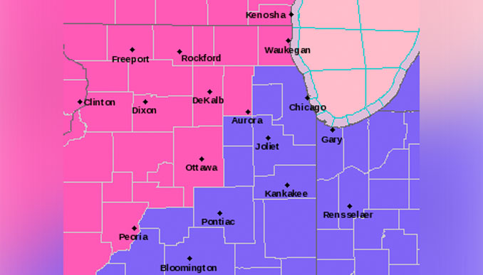
WINTER STORM WARNING IN EFFECT FROM 8 PM MONDAY NIGHT TO
12 AM CST WEDNESDAY
The National Weather Service has opted to upgrade to a winter storm warning for northwestern 1/3 to 1/2 of the Chicagoland area, roughly northwest of a line from Streator to Aurora to Waukegan. Guidance has trended toward shorter break in the precip intensity early Tues AM, so for the sake of simplicity have converted the advisory for tonight to just a warning for the duration of the storm.
Through Tuesday night…
Snow, heavy at times, will overspread the forecast area between about 8 pm and midnight. Vast majority of snowfall expected within about a 3-6 hour window. Snowfall rates will likely reach 1 inch per hour in some areas and could approach 2 inches/hour, particularly with any embedded convective elements.
Winter storm warning will be issued for Lake, Kane, LaSalle Counties westward. Winter weather advisories will be in effect tonight into Tuesday morning remainder of northeast Illinois and northwest Indiana.
Snow, heavy at times, is expected to continue northern portions of the area through much of the day Tuesday, though possibly mixed with or changing to rain near the lake.
Weather Radar shows the leading edge of precipitation approaching a line from Burlington to Peoria to Champaign at 2:45 p.m. Monday.
See also Arlingtoncardinal.com/clouds
MCHENRY FORECAST …
Monday Afternoon: Cloudy, with a high near 33. East southeast wind 5 to 10 mph, with gusts as high as 15 mph.
Monday Night: Snow, mainly after 11pm. Low around 32. East wind 10 to 15 mph, with gusts as high as 25 mph. Chance of precipitation is 100%. New snow accumulation of 1 to 3 inches possible.
Tuesday: Snow. High near 33. East wind 10 to 15 mph becoming north in the afternoon. Winds could gust as high as 25 mph. Chance of precipitation is 100%. New snow accumulation of 3 to 7 inches possible.
Tuesday Night: Snow, mainly before midnight. Low around 28. Blustery, with a northwest wind 10 to 15 mph increasing to 20 to 25 mph in the evening. Winds could gust as high as 35 mph. Chance of precipitation is 100%. New snow accumulation of 1 to 2 inches possible.
Wednesday: Cloudy, with a high near 31. West northwest wind 10 to 15 mph becoming southwest in the afternoon. Winds could gust as high as 25 mph.
Wednesday Night: Snow likely, mainly after midnight. Cloudy, with a low around 23. Chance of precipitation is 60%.
Thursday: Partly sunny, with a high near 28.
Thursday Night: A chance of snow after midnight. Cloudy, with a low around 19.
Friday: Snow. Cloudy, with a high near 32. Breezy.
Friday Night: Snow. Cloudy, with a low around 17. Blustery.
Saturday: A chance of snow. Mostly cloudy, with a high near 21. Blustery.
Saturday Night: A chance of snow. Mostly cloudy, with a low around 2. Blustery.
Sunday: A chance of snow. Mostly cloudy, with a high near 11.
january.chicagoweatherstation.com
Chicago Weather Forecast for your MAC/PC/TABLET includes surrounding suburbs.
^^ MOBILE? USE VOICE MIC ^^
facebook …
Please ‘LIKE’ the ‘Arlington Cardinal Page. See all of The Cardinal Facebook fan pages at Arlingtoncardinal.com/about/facebook …
Help fund The Cardinal Arlingtoncardinal.com/sponsor
WINTER STORM WARNING …
URGENT – WINTER WEATHER MESSAGE
National Weather Service Chicago IL
207 PM CST Mon Jan 8 2024
ILZ006-012-019-090415-
/O.UPG.KLOT.WW.Y.0001.240109T0200Z-240110T0000Z/
/O.NEW.KLOT.WS.W.0001.240109T0200Z-240110T0600Z/
Lake IL-Kane-La Salle-
Including the cities of Waukegan, Buffalo Grove, Mundelein,
Gurnee, Aurora, Elgin, Ottawa, Streator, La Salle, Mendota,
and Marseilles
207 PM CST Mon Jan 8 2024
…WINTER STORM WARNING IN EFFECT FROM 8 PM THIS EVENING TO
MIDNIGHT CST TUESDAY NIGHT…
* WHAT…Heavy, wet snow expected. Total snow accumulations of 5
to 8 inches. Winds gusting as high as 35 mph.
* WHERE…Lake IL, Kane and La Salle Counties.
* WHEN…From 8 PM this evening to midnight CST Tuesday night.
* IMPACTS…Travel will be very difficult at times. The hazardous
conditions will impact both the morning and evening commutes.
* ADDITIONAL DETAILS…Snowfall rates in excess of one inch per
hour are possible at times late tonight into Tuesday evening.
Visibilities under one half mile are possible.
PRECAUTIONARY/PREPAREDNESS ACTIONS…
If you must travel, keep an extra flashlight, food, and water in
your vehicle in case of an emergency.
The latest road conditions for Illinois can be obtained on the
internet at www.gettingaroundillinois.com.
&&
$$
