…WINTER STORM WATCH IN EFFECT FROM FRIDAY MORNING THROUGH
SATURDAY MORNING…
Weather forecast and night sky overnight Wednesday to Thursday (January 10-11, 2024) YouTube Tips ⓘ
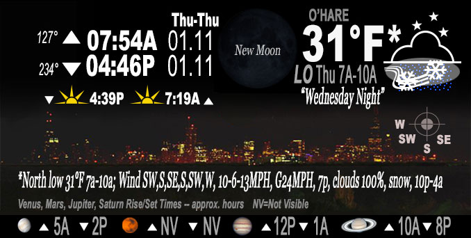
Before the focus on the Winter Storm Watch for Friday into Saturday, we face a round of snow Wednesday night that was forecast to bring about 1.5 inch snow accumulation to the Arlington Heights and O’Hare International Airport area. A quick moving weather disturbance was over eastern Nebraska at about 3:00 p.m. Wednesday, and will continue to progress eastward toward Chicagoland Wednesday evening.
A period of accumulating snow is likely overnight — mainly 10pm-6am for Chicagoland and 12am-4am for Arlington Heights and O’Hare.
UPDATE:
Weather Radar showed the leading edge of a disturbance approaching the northwest suburbs about 9:30 p.m.
The trailing edge of precipitation on radar was over Lake Michigan by 4:00 a.m. Thursday.
Snow began in Arlington Heights about 9:15 p.m. Wednesday, but did not accumulate. There was zero additional snow accumulation on paved surfaces Thursday morning.
The snow cover in Arlington Heights measured about 3.0 inches 10:30 a.m. Thursday, January 11, 2024.
See also Arlingtoncardinal.com/clouds
NWStweet?
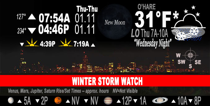
O’HARE FORECAST …
Wednesday Night: Snow, mainly after midnight. Low around 28. South wind 5 to 10 mph. Chance of precipitation is 100%. Total nighttime snow accumulation of 1 to 2 inches possible.
Thursday: Mostly cloudy, with a temperature falling to around 28 by 5pm. West wind 5 to 15 mph, with gusts as high as 20 mph.
Thursday Night: Snow likely, mainly after 3am. Cloudy, with a temperature rising to around 32 by 5am. Southwest wind 5 to 15 mph becoming east after midnight. Winds could gust as high as 20 mph. Chance of precipitation is 60%. New snow accumulation of less than a half inch possible.
Friday: Snow before 9am, then snow, possibly mixed with rain between 9am and 3pm, then snow after 3pm. The snow could be heavy at times. Patchy blowing snow between noon and 5pm. High near 34. Breezy, with an east wind 15 to 20 mph, with gusts as high as 30 mph. Chance of precipitation is 100%. New snow accumulation of 4 to 8 inches possible.
Friday Night: Snow. The snow could be heavy at times. Widespread blowing snow, mainly after 3am. Low around 21. Windy, with a northeast wind 15 to 20 mph becoming northwest 25 to 30 mph in the evening. Winds could gust as high as 45 mph. Chance of precipitation is 100%.
Saturday: Snow likely. Areas of blowing snow before noon. Mostly cloudy, with a high near 23. Windy. Chance of precipitation is 60%.
Saturday Night: A 40 percent chance of snow. Mostly cloudy, with a low around -2. Breezy.
Sunday: A chance of snow after noon. Mostly cloudy and cold, with a high near 7.
Sunday Night: Mostly cloudy, with a low around -11.
M.L.King Day – Monday: Partly sunny and cold, with a high near 2.
Monday Night: Mostly cloudy, with a low around -7.
Tuesday: Partly sunny and cold, with a high near 6. Breezy.
Tuesday Night: Mostly cloudy, with a low around -1. Breezy.
Wednesday: Partly sunny, with a high near 12.
LAKE TEMPS …
SOUTHERN LAKE MICHIGAN WATER TEMPERATURES
NATIONAL WEATHER SERVICE CHICAGO/ROMEOVILLE IL
911 AM CST Wed Jan 10 2024
LAKE MICHIGAN WATER TEMPERATURES…
CHICAGO SHORE………..37.
CHICAGO CRIB…………39.
MICHIGAN CITY………..39.
SOUTH MID LAKE BUOY…..42.
&&
M IS FOR MISSING DATA THAT IS NORMALLY AVAILABLE.
THE MICHIGAN CITY WATER TEMPERATURE SENSOR IS LOCATED AT A WATER INTAKE ONE MILE OFFSHORE AND 60 FEET BELOW THE WATER SURFACE. IT IS READ EVERY DAY OF THE YEAR.
january.chicagoweatherstation.com
Chicago Weather Forecast for your MAC/PC/TABLET includes surrounding suburbs.
^^ MOBILE? USE VOICE MIC ^^
facebook …
Please ‘LIKE’ the ‘Arlington Cardinal Page. See all of The Cardinal Facebook fan pages at Arlingtoncardinal.com/about/facebook …
Help fund The Cardinal Arlingtoncardinal.com/sponsor
WINTER STORM WATCH …
URGENT – WINTER WEATHER MESSAGE
National Weather Service Chicago IL
218 PM CST Wed Jan 10 2024
ILZ005-006-012-013-023-103>108-INZ001-002-110430- /O.NEW.KLOT.WS.A.0002.240112T1200Z-240113T1800Z/ McHenry-Lake IL-Kane-DuPage-Kankakee-Northern Cook-Central Cook- Southern Cook-Northern Will-Southern Will-Eastern Will-Lake IN- Porter- Including the cities of Crystal Lake, Algonquin, McHenry, Woodstock, Waukegan, Buffalo Grove, Mundelein, Gurnee, Aurora, Elgin, Naperville, Wheaton, Downers Grove, Lombard, Carol Stream, Kankakee, Bourbonnais, Bradley, Evanston, Des Plaines, Schaumburg, Palatine, Northbrook, Chicago, Cicero, Oak Lawn, Oak Park, La Grange, Calumet City, Oak Forest, Lemont, Orland Park, Park Forest, Joliet, Bolingbrook, Plainfield, Mokena, Channahon, Manhattan, Wilmington, Crete, Peotone, Beecher, Gary, Hammond, Merrillville, Portage, Valparaiso, and Chesterton 218 PM CST Wed Jan 10 2024
…WINTER STORM WATCH IN EFFECT FROM FRIDAY MORNING THROUGH SATURDAY MORNING…
* WHAT…Heavy snow and blowing snow possible. Total snow accumulations greater than 6 inches possible. Winds could gust as high as 45 to 50 mph.
* WHERE…Portions of northeast Illinois and northwest Indiana.
* WHEN…From Friday morning through Saturday morning.
* IMPACTS…Travel could be dangerous. Areas of blowing snow could significantly reduce visibility. The hazardous conditions will likely impact both Friday commutes. Gusty winds could bring down tree branches.
* ADDITIONAL DETAILS…The strongest winds with the potential for periods of blizzard conditions are expected Friday evening into early Saturday. Warmer temperatures near Lake Michigan will likely cut into snow accumulations during the day on Friday.
PRECAUTIONARY/PREPAREDNESS ACTIONS…
Monitor the latest forecasts for updates on this situation.
&&
$$
— Castro/NWS Chicago