Weather overnight January 02/03, 2024. YouTube Tips ⓘ
Some areas of slick travel, especially bridges, early Wednesday morning across portions of northern Illinois due to lingering light mist and light freezing drizzle.
Period of flurries and snow showers this afternoon/early evening with little to no accumulation expected.
Period of lake effect snow showers tonight into Thursday morning, primarily across northwestern Indiana where some minor accumulations are possible.
Temperatures continue to hover at, or just below, freezing across the area early this morning. Unfortunately, low clouds and even some areas of very light freezing drizzle have been reported across the area. While impacts from this very light freezing drizzle are expected to remain minor, some slick spots have developed on bridges and overpasses in and around the Rockford area, per calls to the Winnebago Sheriffs office and the Rockford observer. Farther south and east into the Chicago metro area temperatures also remain parked right at 32 degrees with this light drizzle moving across the area. As a result, some patchy slick spots can be expected through daybreak on area bridges and overpasses, along with untreated roads. Since any slick spots are expected to remain patchy for the next few hours this morning we will handle this with an SPS and updated graphic highlighting this message.
Weather Radar in northeast Illinois was clear.
See also Arlingtoncardinal.com/clouds
[4:23 AM CST 1/3] Thru ~7 AM CST, if you will be driving, be alert for patchy slick spots in and near pink shaded area, especially on bridges and overpasses. Leave extra travel time. Slow down and increase following distance. #ILwx #INwx pic.twitter.com/iXRP8qlqHR
— NWS Chicago (@NWSChicago) January 3, 2024
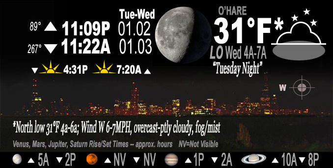
O’HARE FORECAST …
Overnight Tuesday/Wednesday: A slight chance of drizzle, snow, and freezing drizzle. Cloudy, with a low around 29. West wind around 5 mph. Chance of precipitation is 20%.
Wednesday: Patchy drizzle, snow showers, and freezing drizzle before noon, then scattered flurries between noon and 3pm, then a slight chance of snow showers after 3pm. Cloudy, with a high near 35. West northwest wind 5 to 10 mph, with gusts as high as 15 mph. Chance of precipitation is 20%.
Wednesday Night: Scattered flurries with isolated snow showers before midnight, then scattered flurries between midnight and 3am. Mostly cloudy, with a low around 26. North wind around 10 mph. Chance of precipitation is 20%.
Thursday: Mostly sunny, with a high near 34. North wind around 5 mph becoming calm in the afternoon.
Thursday Night: Partly cloudy, with a low around 24. South southwest wind around 5 mph.
Friday: Mostly cloudy, with a high near 36.
Friday Night: A 20 percent chance of snow showers after midnight. Mostly cloudy, with a low around 29.
Saturday: A chance of snow showers. Mostly cloudy, with a high near 37.
Saturday Night: A chance of snow showers. Mostly cloudy, with a low around 29.
Sunday: A chance of snow showers before noon. Mostly cloudy, with a high near 36.
Sunday Night: Mostly cloudy, with a low around 28.
Monday: Cloudy, with a high near 38.
Monday Night: Rain and snow likely. Cloudy, with a low around 32.
Tuesday: Rain and snow. Cloudy, with a high near 36.
LAKE TEMPS …
SOUTHERN LAKE MICHIGAN WATER TEMPERATURES
NATIONAL WEATHER SERVICE CHICAGO/ROMEOVILLE IL
912 AM CST Tue Jan 2 2024
LAKE MICHIGAN WATER TEMPERATURES…
CHICAGO SHORE………..39.
CHICAGO CRIB…………43.
MICHIGAN CITY………..40.
SOUTH MID LAKE BUOY…..43.
NORTH MID LAKE BUOY…..42.
&&
M IS FOR MISSING DATA THAT IS NORMALLY AVAILABLE.
THE MICHIGAN CITY WATER TEMPERATURE SENSOR IS LOCATED AT A WATER INTAKE ONE MILE OFFSHORE AND 60 FEET BELOW THE WATER SURFACE. IT IS READ EVERY DAY OF THE YEAR.
january.chicagoweatherstation.com
Chicago Weather Forecast for your MAC/PC/TABLET includes surrounding suburbs.
^^ MOBILE? USE VOICE MIC ^^
facebook …
Please ‘LIKE’ the ‘Arlington Cardinal Page. See all of The Cardinal Facebook fan pages at Arlingtoncardinal.com/about/facebook …
Help fund The Cardinal Arlingtoncardinal.com/sponsor
20240105-1435future
Area Forecast Discussion
National Weather Service
Chicago/Romeoville, IL 336 AM CST Wed Jan 3 2024
.SHORT TERM… Issued at 330 AM CST Wed Jan 3 2024
Through Thursday…
Key Messages:
– Some ares of slick travel early this morning across portions of northern IL due to lingering light mist and light freezing drizzle.
– Period of flurries and snow showers this afternoon/early evening with little to no accumulation expected.
– Period of lake effect snow showers tonight into Thursday morning, primarily across northwestern IN where some minor accumulations are possible.
Temperatures continue to hover at, or just below, freezing across the area early this morning. Unfortunately, low clouds and even some areas of very light freezing drizzle have been reported across the area. While impacts from this very light freezing drizzle are expected to remain minor, some slick spots have developed on bridges and overpasses in and around the Rockford area, per calls to the Winnebago Sheriffs office and the Rockford observer. Farther south and east into the Chicago metro area temperatures also remain parked right at 32 degrees with this light drizzle moving across the area. As a result, some patchy slick spots can be expected through daybreak on area bridges and overpasses, along with untreated roads. Since any slick spots are expected to remain patchy for the next few hours this morning we will handle this with an SPS and updated graphic highlighting this message.
Current thinking is that this drizzle/freezing drizzle threat may begin to wane across the area around, or shortly after, daybreak as a weak surface trough continues to shift southeastward out of the area. This thinking is supported by the fact that upstream observations across southern WI continue to show improving ceilings and visibilities, suggesting that the drizzle threat has already ended north of the WI state line. These improving trends are thus anticipated across our area through the early morning hours.
Another fast moving mid-level impulse, currently shifting southward across the Upper Midwest, is slatted to drop across our area this afternoon. This is expected to foster some afternoon and evening flurries and snow showers across the area as low- level lapse rates steepen and push cloud heights into the DGZ. Little to no accumulation is anticipated, so no travel impacts are expected.
Lake effect snow showers are expected to persist across portions of northwestern IN tonight into early Thursday morning as the flow turns northerly down the lake. These showers are generally expected to remain rather unorganized due to the marginal thermodynamic setup on the lake. However, we may have a couple hour period later this evening into the early overnight hours supportive of some better organized bands of showers as lakeshore convergence maximizes with the arrival of the surface cold front. Accordingly, some minor accumulations up around an inch are plausible across parts of Lake and Porter counties in IN tonight. Otherwise, the lake effect snow showers will dissipate Thursday morning as a surface high approaches the western Great Lakes.
— KJB/NWS Chicago