
A weather system that could possibly dump deep, wet snow on Chicagoland has a potential to advance to Chicagoland Friday — especially affecting far west suburbs, northwest suburbs, McHenry County and western Lake County.
The upper level northern jet stream is expected to dig across the western United States mid-week, bringing a potent developing Low pressure system into the desert southwest late Wednesday into Thursday.
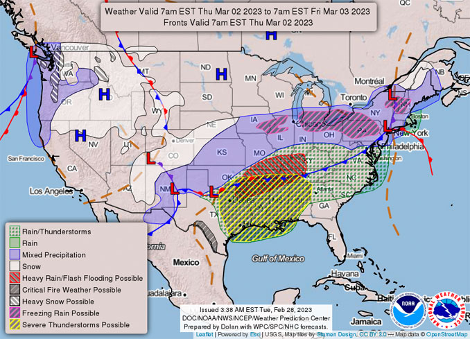
According to NWS Chicago, the weather system will waste no time sitting around, with rapid ejection of a cut-off Low Thursday through the southwest United States into Texas by Thursday evening.
As this system rapidly arrives in the southern Plains — along with the frontal boundary lingering — a strong moisture ingest will occur from the Gulf of Mexico. This system gets driven north northeast late Thursday evening into Friday, while a ridge of High pressure east of the Bahamas dominates the weather pattern across the southeast United States.
The cut-off Low is forecast to track northeast through the mid-Mississippi River Valley Friday, impacting the local area beginning late Thursday night through Friday. With the track of this system close to the area, winds will ramp up Friday. The NBM (National Blend of Model) was too high with long term winds, so collaboration with neighboring weather service offices reduced values of sustained and gusts to less than advisory criteria.
The system is forecast to continue tracking into the eastern Great Lakes Friday night.
Precipitation with the Friday system currently appears very messy — wet snow and sleet. NWS Chicago is predicting Snow ratios of less than 9:1 (9 inches of snow holding 1 inch of water). As the track of this system still has some minor movement over the next couple of days, an exact location of rain/snow lines or amounts are expected to change.
Currently, GFS/ECMWF models are close in agreement for the storm track, and the deepest snow (high 8-inch to mid 9-inch range) near Chicagoland is modeling around Algonquin, Cary, Crystal Lake, Prairie Grove, McHenry, Johnsburg, Spring Grove, Hebron, Genoa City (Wisconsin) and Twin Lakes (Wisconsin).
The margin from 7 inches to 8 inches is taking shape west of South Barrington in a line to around northern Buffalo Grove, Long Grove, Vernon Hills, and Lindenhurst.
The modeling for the 10-mile long Arlington Heights community is shaping up to receive a wet snow dump of about 7.4 inches near Lake Cook Road, 7.4 inches near Palatine Road, and 7.2 inches near Algonquin Road.
If the track is wrong and goes north, we will be facing a threat of heavy rain with thunderstorms.
If the track goes south, the deepest snow will be in the south Chicago suburbs and Indiana.
The Canadian model remains the main outlier with its projected southerly projected path still further south along the Ohio River Valley…however as typical Canadian model fashion it is beginning to lift closer to GFS/EMCWF models. With the projected path of the models, this leaves the local LOT area on the northern side of this system, which typically would bring about snowfall. However with the track of this system, and enhanced warm, moist air being lifted out of the Gulf, first run p-type (precipitation type) is a mixed rain/snow event for much of the area. Rain is expected at the start Thursday night as the system lifts north, but a change to mixed precip is likely Friday morning, lasting throughout the afternoon. With the excess moisture influx, this event is starting to take a heavy, wet snow/mixed precip event, which could lead to messy conditions across northern Illinois and northwest Indiana Friday afternoon and evening.
As for temperatures over the period, cooler conditions settle in beginning Thursday behind the frontal passage, and linger through
the weekend.
^^ MOBILE? USE VOICE MIC ^^
facebook …
Please ‘LIKE’ the ‘Arlington Cardinal Page. See all of The Cardinal Facebook fan pages at Arlingtoncardinal.com/about/facebook …
Help fund The Cardinal Arlingtoncardinal.com/sponsor
20240105-1435future
THANKS FOR READING CARDINAL NEWS
