
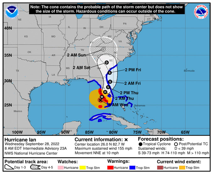
At 7:30 ET Hurricane Ian was a Category 4 hurricane with maximum sustained winds of 155 MPH, which is on the verge of becoming a Category 5 hurricane. The track has turned to affect Fort Myer area more than the Tampa Bay area. Hurricane Ian is forecast this morning to make landfall in a similar track that occurred with Hurricane Charley (strong Category 4) in August 2004. Hurricane Charley is
The storm surge forecast was upped to 18 feet near Fort Myers, Florida.
Primary Hazards
There are four primary hazards of a hurricane at the coast, and three major hazards inland …
High Winds
Surge (at the Coast)
Tornadoes
Heavy Rain
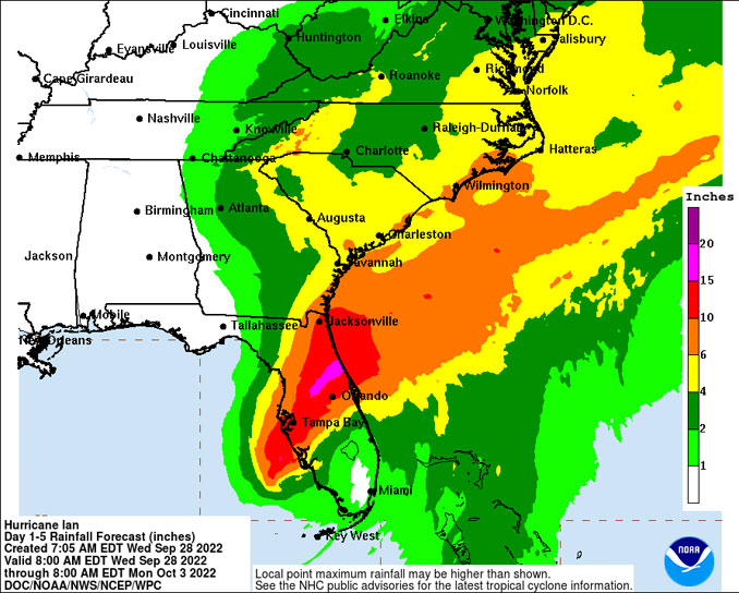
NWS Point Forecast accumulated rainfall totals from Wednesday morning (8AM ET Sep. 28 2022) to Friday morning (8AM ET Sep. 30 2022).
Cape Coral Florida … 4.08″
Cape Canaveral … 6.71″
Clearwater … 8.28″
*Daytona Beach … 15.03″
Fort Myers … 3.83″
Groveland … 15.53″
*Jacksonville … 9.64″
Lakeland … 12.80″
Lake Buena Vista (Disney World) … 11.77″
Ocala … 9.62″
Orlando … 11.64″
Sarasota … 12.03″
*St. Augustine … 12.97″
Tampa … 9.41″
================================
Extra time to 5p to include complete tropical storm
*Daytona Beach (until 5p) … 15.66″
*Jacksonville (until 5p) … 11.69″
*St. Augustine (until 5p) … 14.26″
To find the total rain hourly point forecast, Google “nws [CITY NAME STATE NAME] 7 day forecast” (no brackets) and look for “Hourly Weather Forecast” then add up the hourly rainfall amounts for time range displayed.
Secondary Hazards
Secondary hazards created by the hurricane ..
energized downed power lines present electrocution risk
damaged structures including building collapses, and overhead power lines or utility equipment that could still fall present risks of traumatic injuries and fatal traumatic injuries
damaged trees that could still fall or branches with weight shifts present risk of traumatic injuries or fatal traumatic injuries
standing water of unknown depth presents drowning risk and electrocution risk if located near a downed power line.
debris presents risk of lacerations and trauma due to trips and falls
unsecured debris in water presents collision risks that could cause trauma and drowning
disrupted environment presents risk of exposure to dangerous animals
