
In Arlington Heights, light snow may begin about 10:00 p.m. Saturday, and accumulate to a 0.4″ by midnight Saturday/Sunday. The highest snowfall rate will occur between 12:00 a.m. and 4:00 a.m. when at least another 2.1 inches of snow is expected to accumulate. The snow is expected to be dry and fluffy.
Snow Depth Forecast
Arlington Heights … 2.5″
Antioch … 1.8″
DeKalb … 3.3″
Elgin … 2.9″
Hampshire … 2.9″
Highland Park … 2.1″
Kenosha … 1.2″
Lake Forest … 2.1″
McHenry … 2.2″
Midway … 3.4″
O’Hare … 2.7″
Orland Park … 3.0″
Rockford … 3.3″
Schaumburg … 2.7″
Vernon Hills … 2.2″
Waukegan … 1.8″
Wheaton … 3.0″
West Chicago … 3.1″
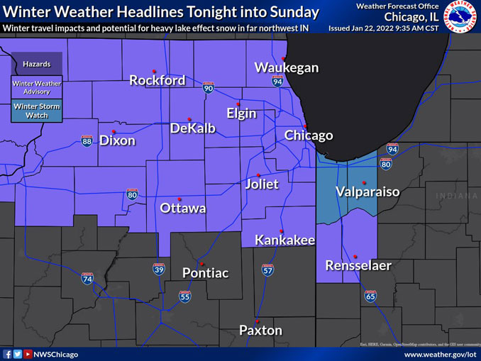
According to the NWS Chicago, confidence is continuing to increase regarding a forecast for a period of steady moderate, to at times heavy snow rates Saturday night and early Sunday morning. The NWS office Chicago opted to issue a winter weather advisory for much of the area, with the exception of Chicagoland’s far southern tier counties. The early morning forecast guidance continues to support a period of strongly forced ascent right across northern IL into northwestern IN as a quick moving clipper system shifts across the area tonight. The combination of the strongly forced ascent and favorably deep dendritic growth zone will support an efficient high ratio type snow up to 20:1. Therefore, it appears snow amounts could end up in the 2 to 5 inch range, with the highest amounts looking to be roughly from the Rockford area, east-southeastward into parts of the Chicago metro area and into northwestern Indiana.
The concern for lake effect snow continuing to accumulate in parts of Lake and Porter counties Indiana on Sunday lead us to issue a winter storm watch for these counties. This was done as we would like to get a closer look at all of the latest hires guidance before making a decision on an advisory or warning for this area. If the lake effect snow materializes, travel impacts would likely be higher and persist longer here, likely through much of the day Sunday. Total snow accumulations as a result could exceed 6 inches in some parts of Lake and Porter counties in Indiana.
Weather Radar shows precipitation observed as snow flurries dissipating, moving from southeast Wisconsin into McHenry County and Lake County at 10:20 a.m. Otherwise Weather Radar in northeast Illinois was clear.
See also Arlingtoncardinal.com/clouds
[10:08AM 1/22] Winter headlines in effect for accumulating snow & winter travel impacts tonight into Sun. Advisory (purple shading) starts 9pm this eve. Winter Storm Watch for Lake & Porter IN is for potentially heavy lake effect snow after system snow ends Sun. AM. #ilwx #inwx pic.twitter.com/nq7a2B2pxo
— NWS Chicago (@NWSChicago) January 22, 2022
Accumulating snow is expected tonight with a swath of 2 to 4 inches possible between I-90 and I-80. There is another chance for accumulating snow late Sunday night into Monday morning. #ILWX #INWX pic.twitter.com/XzEmEKpsuB
— NWS Chicago (@NWSChicago) January 22, 2022
Very light snow or flurries will move across the area through mid-morning, with a dusting of snow accumulation possible. Accumulating snow will move across the area late tonight and continue through daybreak Sunday morning. #ILWX #INWX pic.twitter.com/vhkNmAuUQL
— NWS Chicago (@NWSChicago) January 22, 2022
Winter Weather Advisory URGENT – WINTER WEATHER MESSAGE National Weather Service Chicago IL 921 AM CST Sat Jan 22 2022
ILZ006-013-023-103>108-INZ010-011-222330- /O.NEW.KLOT.WW.Y.0004.220123T0300Z-220123T1500Z/ Lake IL-DuPage-Kankakee-Northern Cook-Central Cook-Southern Cook- Northern Will-Southern Will-Eastern Will-Newton-Jasper- Including the cities of Waukegan, Buffalo Grove, Mundelein, Gurnee, Naperville, Wheaton, Downers Grove, Lombard, Carol Stream, Kankakee, Bourbonnais, Bradley, Evanston, Des Plaines, Schaumburg, Palatine, Northbrook, Chicago, Cicero, Oak Lawn, Oak Park, La Grange, Calumet City, Oak Forest, Lemont, Orland Park, Park Forest, Joliet, Bolingbrook, Plainfield, Mokena, Channahon, Manhattan, Wilmington, Crete, Peotone, Beecher, Roselawn, Kentland, Morocco, Rensselaer, and DeMotte 921 AM CST Sat Jan 22 2022
…WINTER WEATHER ADVISORY IN EFFECT FROM 9 PM THIS EVENING TO 9 AM CST SUNDAY…
* WHAT…Snow expected. Total snow accumulations of 2 to 5 inches.
* WHERE…Portions of northwest Indiana and northeast Illinois.
* WHEN…From 9 PM this evening to 9 AM CST Sunday.
* IMPACTS…Plan on slippery road conditions and sharply reduced visibilities with the heaviest snow.
PRECAUTIONARY/PREPAREDNESS ACTIONS…
Slow down and use caution while traveling.
In Illinois, the latest road conditions for Illinois can be obtained on the internet at www.gettingaroundillinois.com. In Indiana, the latest road conditions for Indiana are available by calling 1-800-261-7623.
O’HARE FORECAST …
Today: Mostly cloudy, with a high near 29. West wind around 15 mph, with gusts as high as 30 mph.
Tonight: Snow, mainly after 10pm. Low around 15. West wind 5 to 10 mph becoming north after midnight. Winds could gust as high as 15 mph. Chance of precipitation is 100%. New snow accumulation of 2 to 4 inches possible.
Sunday: A 40 percent chance of snow, mainly before 8am. Cloudy through mid morning, then gradual clearing, with a high near 21. Wind chill values as low as zero. North northwest wind 5 to 15 mph, with gusts as high as 20 mph.
Sunday Night: A 50 percent chance of snow after midnight. Increasing clouds, with a low around 13. West northwest wind 5 to 15 mph becoming south southwest after midnight. Winds could gust as high as 20 mph.
Monday: A 30 percent chance of snow, mainly before noon. Cloudy, with a high near 34. South southwest wind 10 to 15 mph becoming northwest in the afternoon. Winds could gust as high as 25 mph.
Monday Night: Mostly cloudy, with a low around 10.
Tuesday: Mostly sunny, with a high near 18.
Tuesday Night: Partly cloudy, with a low around 2.
Wednesday: Mostly sunny, with a high near 16.
Wednesday Night: Partly cloudy, with a low around 7.
Thursday: Partly sunny, with a high near 28.
Thursday Night: Mostly cloudy, with a low around 18.
Friday: Partly sunny, with a high near 29.
LAKE TEMPS …
SOUTHERN LAKE MICHIGAN WATER TEMPERATURES
NATIONAL WEATHER SERVICE CHICAGO/ROMEOVILLE IL
939 AM CST Sat Jan 22 2022
LAKE MICHIGAN WATER TEMPERATURES…
CHICAGO SHORE………33.
CHICAGO CRIB……….33.
MICHIGAN CITY……….33.
&&
M IS FOR MISSING DATA THAT IS NORMALLY AVAILABLE.
THE MICHIGAN CITY WATER TEMPERATURE SENSOR IS LOCATED AT A WATER
INTAKE ONE MILE OFFSHORE AND 60 FEET BELOW WATER SURFACE. IT IS READ EVERY DAY OF THE YEAR.
january.chicagoweatherstation.com
Chicago Weather Forecast for your MAC/PC/TABLET includes surrounding suburbs.
^^ MOBILE? USE VOICE MIC ^^
facebook …
Please ‘LIKE’ the ‘Arlington Cardinal Page. See all of The Cardinal Facebook fan pages at Arlingtoncardinal.com/about/facebook …
Help fund The Cardinal Arlingtoncardinal.com/sponsor
20240105-1435future
