If intense lake effect snow doesn’t ramp up into northwest Cook County, Arlington Heights and surrounding communities can expect about 3.5 to 4 inches of snowfall from late Sunday night to early Tuesday morning. If lake effect snow is higher than expected, Arlington Heights and surrounding communities could experience 6 to 8 inches of fluffy, dry snow from late Sunday night to early Tuesday morning. Deeper lake effect snow is more likely to occur closer to the Lake Michigan shoreline because the wind factor of the “snow machine” is from the north.
UPDATE …
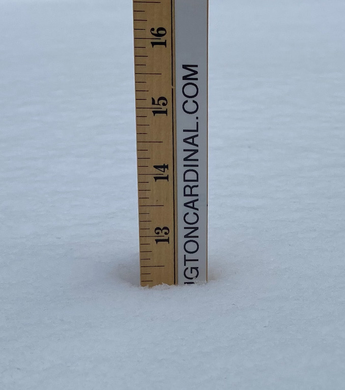
WINTER STORM WARNING: 11 Inches of New Snowfall Forecast 6AM Monday to 6AM Tuesday
Light snow could begin as early as 3:00 p.m. Sunday with snow intensity noticeably increasing about 6:00 p.m. Sunday, and increasing in intensity again with a lake snow effect at about 11:00 p.m. to midnight, and continuing with intense snow until midnight Monday/Tuesday. Snowfall will taper off after midnight Monday/Tuesday, but continue at low intensity until about 5:00 p.m. Tuesday.
Winds will gust up to about 20 MPH from the north from about 5:00 p.m. Sunday to midnight Monday/Tuesday.
A Winter Storm Watch was issued for Cook County and Lake County Indiana for late Sunday Night (estimated about 11:00 p.m.) through early Tuesday (about 8:00 a.m.). The Winter Storm Watch was issued for the increasing potential for a significant and persistent lake effect snow event in Chicagoland on top of a Winter Weather Advisory zone. Another very large Winter Storm Warning area (Weather Channel: Winter Storm Uri) was activated for a large winter storm system expected to move across the southern United States including all or parts of New Mexico, Texas, Oklahoma, Nebraska, Arkansas, Louisiana, Mississippi, Missouri, southern Illinois, southern Indiana, Kentucky, Alabama, Tennessee, West Virginia, and Ohio.
Outside of the lake effect Chicagoland Winter Storm Watch area, the Chicagoland Winter Weather Advisory has been issued for tonight through late Monday night for all counties along and east of the I-57 corridor. The Winter Weather Advisory was activated due to the expectation of 2 to 5 inch snowfall amounts from the next approaching weather system, which is associated with the system bringing the Winter Storm Warning across the south.
Weather Radar shows snow moving northeast in western Illinois, northwest Illinois (including Rockford), and southeast Wisconsin at 12:25 p.m. Sunday, February 14, 2021.
Lake effect snow starts Sun afternoon starting in NW IN, while wide-spread light snow starts Sun evening for other locations, with heaviest snow SE of I-55. Lake effect snow slowly shifts further east Sun night into Mon, including near the city of Chicago. #ilwx #inwx pic.twitter.com/jisByeFoTh
— NWS Chicago (@NWSChicago) February 14, 2021
Cold Gusty winds + cold = dangerous wind chills today into Mon. Another snow system approaches Sun PM with light snow; heavier snow along IN lake shore, which shifts towards IL shore Mon AM. Snow continues into Mon night, with heaviest amounts SE of I-55. #ilwx #inwx. pic.twitter.com/qDQctgiJcF
— NWS Chicago (@NWSChicago) February 14, 2021
NEW: Every single county in Oklahoma, Arkansas, and Texas is now under a Winter Storm Warning. #Uri pic.twitter.com/nDbBk5EDNj
— The Weather Channel (@weatherchannel) February 14, 2021
O’HARE FORECAST …
Winter Storm Watch Late Sunday to Early Tuesday
Wind Chill Advisory Sunday through Mid-Day Monday
(Wind Chill Warning ended earlier Sunday)
This Afternoon: A 20 percent chance of snow after 3pm. Mostly cloudy and cold, with a high near 6. Wind chill values as low as -14. North northwest wind 10 to 15 mph.
Tonight: Snow likely, mainly after midnight. Cloudy, with a low around -1. Wind chill values as low as -21. North northwest wind 10 to 15 mph, with gusts as high as 20 mph. Chance of precipitation is 60%. New snow accumulation of less than a half inch possible.
Washington’s Birthday: Snow likely. Mostly cloudy, with a high near 11. Wind chill values as low as -19. North wind 10 to 15 mph, with gusts as high as 20 mph. Chance of precipitation is 70%. New snow accumulation of 1 to 3 inches possible.
Monday Night: Snow likely, mainly before midnight. Mostly cloudy, with a low around 5. Wind chill values as low as -9. North wind 5 to 10 mph, with gusts as high as 15 mph. Chance of precipitation is 60%. New snow accumulation of 1 to 2 inches possible.
Tuesday: A 40 percent chance of snow showers. Mostly cloudy, with a high near 18. North wind around 5 mph, with gusts as high as 10 mph.
Tuesday Night: A 20 percent chance of snow showers before midnight. Mostly cloudy, with a low around 5.
Wednesday: Mostly cloudy, with a high near 21.
Wednesday Night: A slight chance of snow after midnight. Mostly cloudy, with a low around 15.
Thursday: A chance of snow, mainly after noon. Mostly cloudy, with a high near 27.
Thursday Night: A slight chance of snow before midnight. Mostly cloudy, with a low around 12.
Friday: Mostly sunny, with a high near 23.
Friday Night: Partly cloudy, with a low around 9.
Saturday: Mostly sunny, with a high near 29.
LAKE TEMPS …
SOUTHERN LAKE MICHIGAN WATER TEMPERATURES
NATIONAL WEATHER SERVICE CHICAGO/ROMEOVILLE IL
920 AM CST Sun Feb 14 2021
LAKE MICHIGAN WATER TEMPERATURES…
CHICAGO SHORE……….36.
CHICAGO CRIB……….36.
MICHIGAN CITY……….32.
&&
M IS FOR MISSING DATA THAT IS NORMALLY AVAILABLE.
THE MICHIGAN CITY WATER TEMPERATURE SENSOR IS LOCATED AT A WATER INTAKE ONE MILE OFFSHORE AND 60 FEET BELOW WATER SURFACE. IT IS READ
EVERY DAY OF THE YEAR.
february.chicagoweatherstation.com
Chicago Weather Forecast for your MAC/PC/TABLET includes surrounding suburbs.
^^ MOBILE? USE VOICE MIC ^^
facebook …
Please ‘LIKE’ the ‘Arlington Cardinal Page. See all of The Cardinal Facebook fan pages at Arlingtoncardinal.com/about/facebook …
Help fund The Cardinal Arlingtoncardinal.com/sponsor
20240105-1435future