SOUTHEAST LAKE COUNTY ILLINOIS AND NORTHEAST COOK COUNTY COULD SEE 14 INCHES OF NEW SNOW
The snowfall forecast overnight was on the mark, but the conditions of the latter half of the storm system have worsened to include a deeper snowfall forecast.
The Winter Storm Warning area that was associated with a winter storm system passing to our south has been expanded to included northeast Illinois, most of central Illinois and southern Illinois. 1.5 to 2 inches of new snow has fallen overnight — part of the 3-4 inches total that WAS forecast to accumulate by Tuesday morning. However, the updated forecast has expanded the powerful zone of the cross-country snowstorm to include Chicagoland. The track of the upper level short wave was originally positioned further southeast of our region, but the present track has shifted further north with each model run, according to the National Weather Service in Chicago. The shift north amounts to a distance almost the entire length of Illinois. Lake effect snow is also still a factor.
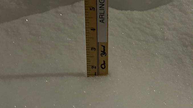
In the updated forecast, light intensity snowfall is forecast from 6:00 a.m. to noon Monday, then a period of intense snowfall is forecast from noon Monday to 5:00 a.m. Tuesday. In Arlington Heights, an additional 10.8 inches of new snowfall is forecast to occur between 6:00 a.m. Monday and 6:00 a.m. Tuesday. The deepest snow forecast is expected in Cook County and southeast Lake County where 10 to 14 inches or more are possible.
Winds are forecast to be from the north, NORTH-NORTHEAST, and north-northwest as the snowstorm progresses. Gusts will persist around 20 MPH, peaking about 5:00 p.m. Monday, and tapering off after 11:00 p.m. Monday. North-northeast winds may enhance lake effect snow from 1:00 p.m. to 5:00 p.m.; but the highest snowfall rates are forecast between 6:00 p.m. Monday and midnight Monday/Tuesday.
Weather Radar) shows light snow bands moving to the northeast over most of northeast Illinois at 6:20 a.m.
Lake effect snow continues this AM in NW IN, along with wide-spread light snow. Snowfall continues throughout Mon, increasing in the late afternoon. Expect heaviest snow SE of I-55, while lake effect snow shifts further west, including near the city of Chicago. #ilwx #inwx pic.twitter.com/UD9BI0iLY1
— NWS Chicago (@NWSChicago) February 15, 2021
Here is a generalized timeline of when snow is expected to fall pic.twitter.com/vbccLs5X7a
— NWS Chicago (@NWSChicago) February 15, 2021
Wide spread light snow, with areas of moderate snow continue through this morning into the afternoon. Lake Effect Snow is creating moderate snowfall along the NW Indiana Shore. This area of lake effect snow will move west into east Cook County later this morning. #ilwx #inwx pic.twitter.com/paGtBAGPeQ
— NWS Chicago (@NWSChicago) February 15, 2021
Snow continues today, increasing in snowfall rates this afternoon. Snow continues overnight into Tue morning. Heaviest snow rates/ snowfall totals will occur near the lake pic.twitter.com/AMNHhFA10G
— NWS Chicago (@NWSChicago) February 15, 2021
O’HARE FORECAST …
Winter Storm Warning (issued 2:51 a.m. Monday February 15, 2021) from Monday morning February 15, 2021 to noon Tuesday, February 16, 2021.
Monday Washington’s Birthday: Snow. Patchy blowing snow. High near 12. Wind chill values as low as -18. North wind around 15 mph, with gusts as high as 25 mph. Chance of precipitation is 100%. Total daytime snow accumulation of 2 to 4 inches possible.
Tonight: Snow. The snow could be heavy at times. Patchy blowing snow. Low around 8. Wind chill values as low as -8. North wind 10 to 15 mph, with gusts as high as 25 mph. Chance of precipitation is 100%. New snow accumulation of 6 to 10 inches possible.
Tuesday: A 50 percent chance of snow, mainly before noon. Mostly cloudy, with a high near 19. Wind chill values as low as -5. North northwest wind 5 to 10 mph, with gusts as high as 15 mph.
Tuesday Night: Partly cloudy, with a low around 4. North northwest wind around 5 mph becoming calm after midnight.
Wednesday: Mostly cloudy, with a high near 21. Light and variable wind becoming east 5 to 10 mph in the afternoon.
Wednesday Night: A 20 percent chance of snow. Mostly cloudy, with a low around 13.
Thursday: A 30 percent chance of snow. Mostly cloudy, with a high near 26.
Thursday Night: A slight chance of snow before midnight. Mostly cloudy, with a low around 12.
Friday: Partly sunny, with a high near 22.
Friday Night: Partly cloudy, with a low around 6.
Saturday: Mostly sunny, with a high near 26.
Saturday Night: Mostly cloudy, with a low around 17.
Sunday: A chance of snow. Mostly cloudy, with a high near 36.
LAKE TEMPS …
SOUTHERN LAKE MICHIGAN WATER TEMPERATURES
NATIONAL WEATHER SERVICE CHICAGO/ROMEOVILLE IL
920 AM CST Sun Feb 14 2021
LAKE MICHIGAN WATER TEMPERATURES…
CHICAGO SHORE……….36.
CHICAGO CRIB……….36.
MICHIGAN CITY……….32.
&&
M IS FOR MISSING DATA THAT IS NORMALLY AVAILABLE.
THE MICHIGAN CITY WATER TEMPERATURE SENSOR IS LOCATED AT A WATER INTAKE ONE MILE OFFSHORE AND 60 FEET BELOW WATER SURFACE. IT IS READ EVERY DAY OF THE YEAR.
february.chicagoweatherstation.com
Chicago Weather Forecast for your MAC/PC/TABLET includes surrounding suburbs.
^^ MOBILE? USE VOICE MIC ^^
facebook …
Please ‘LIKE’ the ‘Arlington Cardinal Page. See all of The Cardinal Facebook fan pages at Arlingtoncardinal.com/about/facebook …
Help fund The Cardinal Arlingtoncardinal.com/sponsor
20240105-1435future