")
Illinois State Police responded about 9:59 p.m. Wednesday, December 9, 2020 to a report that a gold Ford Explorer was stalled with steam coming from the engine compartment on Interstate 94 East near Mile Marker 23. At 10:03 p.m. an Illinois State Police trooper arrived to find a deadly crash instead of a stalled vehicle. The trooper discovered the crash on I-94 East (southbound) near mile marker 23.25 with a wrecked white SUV passenger vehicle facing the wrong way after the impact, and a semi-trailer truck further ahead down the tollway. The Illinois State Police trooper found a female driver unresponsive, not breathing, without a pulse, and trapped in her SUV.
Deerfield-Bannockburn Fire Protection District firefighters and paramedics were dispatched, and the trooper asked for maintenance/HELP vehicles to be dispatched to block Lane 5 for a risk of a secondary crash as traffic passed the crash scene at high speeds on I-94 near Bannockburn and Riverwoods.
Additional state police troopers arrived and the troopers attempted CPR with use of an AED. Troopers were able to extricate the woman just before Deerfield-Bannockburn firefighters and paramedics arrived. The woman was transported to NorthShore Glenbrook Hospital in Glenview, where she was pronounced dead.
UPDATE: As a result of yesterday’s crash in #Deerfield, one woman has been pronounced dead after her disabled vehicle was struck by a semi-truck. pic.twitter.com/1rqEvkVl4Y
— NorthShore Updates (@UpdatesNorth) December 10, 2020
At approximately 10:15 PM, the #Deerfield Fire Protection District responded to an auto accident on I-94 at mile marker 23. Crews arrived on the scene and found one vehicle with heavy damage and one subject lying on the ground in critical condition. Now on @CapturedNews pic.twitter.com/A7eMFsOe86
— NorthShore Updates (@UpdatesNorth) December 10, 2020
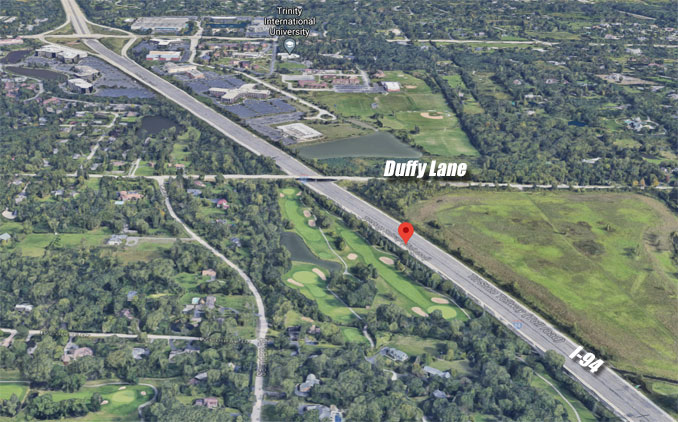
The crashed passenger vehicle was actually a white Mercury SUV, and was disabled in the center lane I-94 East, south of Duffy Lane near Mile Marker 23.25 just before the crash occurred.
The Mercury SUV was struck by a semi-trailer truck traveling southbound on I-94 East (southbound lanes) when the crash occurred.
An extended crash investigation closed Lane 3 and Lane 4 while Lane 1 and Lane 2 were open to traffic. Lane 2 was closed during part of the investigation. All lanes were open about 3:05 a.m.
There is a slight right curve on I-94 East south of Duffy Lane. Near the crash scene, the Speed Limit is 65 MPH for passenger vehicles. The Speed Limit is 60 MPH for trucks over 4 tons, motor homes, campers and trailer, according to Google Maps Street View captured on November 2018.
The crash Wednesday, December 9, 2020 was the second fatal crash in two months involving a stalled vehicle that was hit by a semi-trailer truck on Interstate 94. On Wednesday, October 21, 2020, a semi-trailer truck crashed into the back of a black Toyota that was stalled in the right lane with no hazards lights activated on I-94 East near Rosecrans Road (Route 173) near Old Mill Creek and Wadsworth. The driver of the black Toyota was pronounced dead at the scene.
RELATED NEWS …
Stay informed with news from The Cardinal’s Emergencies Behind the Scenes Facebook page — Facebook.com/CardinalEmergencies. Includes links to favorite public safety and emergency rescuers and product manufacturers and safety companies that have facebook pages. Submit your pictures or just stay up-to-date on with fire, rescue, EMS and police photo galleries. Please add your public safety photo to the wall album — go direct to the Arlington Cardinal Emergencies Behind the Scenes photos. For a list of all of The Cardinal Facebook fan pages, go to Arlingtoncardinal.com/about/facebook …
Help fund The Cardinal Arlingtoncardinal.com/sponsor