January 26-27, 1967: Chicago’s Largest Snowfall on Record
The January, 1967 Blizzard
By Jim Allsopp, Warning Coordination Meteorologist (ret.) & edits by Meteorologist Richard Castro
The Event
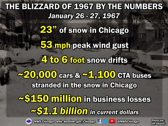
On January 26 and 27, 1967, Chicago endured its worst snowstorm on record. The snow started at 502 AM on the 26th, and by 1010 AM of the 27th a record 23 inches of snow crippled the city. The previous record snow for the city was 19 inches on March 25th and 26th, 1930. During the storm winds gusted to 53 mph at Midway Airport. The high winds caused considerable blowing and drifting. Drifts 4 to 6 feet high were widespread throughout the area.
The heaviest snow fell in the morning and early afternoon of the 26th with the maximum rate of accumulation 2 inches per hour during the late morning. A thunderstorm was reported at Meigs Field. Snow tapered off by evening but intensified again overnight.
Two days before the blizzard, on January 24th, the high temperature was 65 degrees and the low was 44, both records that still stand today. Thunderstorms occurred in the evening of the 24th. There were reports of wind damage, and funnel clouds were spotted in the southwest section of the city. The wind gusted to 48 mph at Midway. The wall of a building under construction at 87th and Stony Island toppled, killing one man and injuring four others.
The Impact
Snow began on Thursday morning, January 26th but most people made it to work and school without much trouble. But by noon about 8 inches was already on the ground and O’Hare Airport was shut down. Some businesses and schools released employees and students early. The commute home, even for those who started early, was a nightmare. Many workers did not get home, or arrived very late. Many stayed at work or in hotels. By Friday morning the city was at a standstill. The airports and local transportation were shut down. In the city of Chicago 20,000 cars and 1,100 CTA buses were stranded in the snow. People walked to stores to clear the shelves of bread and milk. Helicopters were used to deliver medical supplies to hospitals, and food and blankets to stranded motorists. Expectant mothers were taken to hospitals by sled, bulldozer and snow plow. At least a dozen babies were born at home. Looting became a problem on the west and near south sides of the city. Another problem in the aftermath of the storm was low supplies of heating oil. Trucks couldn’t get access to buildings.
By Saturday the 28th, Chicago was beginning to dig itself out. Commuter trains were running and CTA buses were operating most lines. The city sent a workforce of 2,500 people with 500 pieces of equipment out to clear the streets. Iowa, Wisconsin and Michigan sent heavy equipment to help with the snow removal. But the thousands of abandoned vehicles hampered the clean up. Snow was hauled by dump truck to the Chicago River. O’Hare finally opened around midnight Monday, allowing people who had been stranded for days to finally get home. Most schools didn’t reopen until Tuesday. By then most transportation was back to normal.
By the time it was over, 60 people were dead and there was an estimated $150 million in business losses (about $904 million in 2006 dollars). The 1967 snowstorm probably caused the biggest disruption to the commerce and transportation of Chicago of any event since the Great Chicago Fire of 1871.
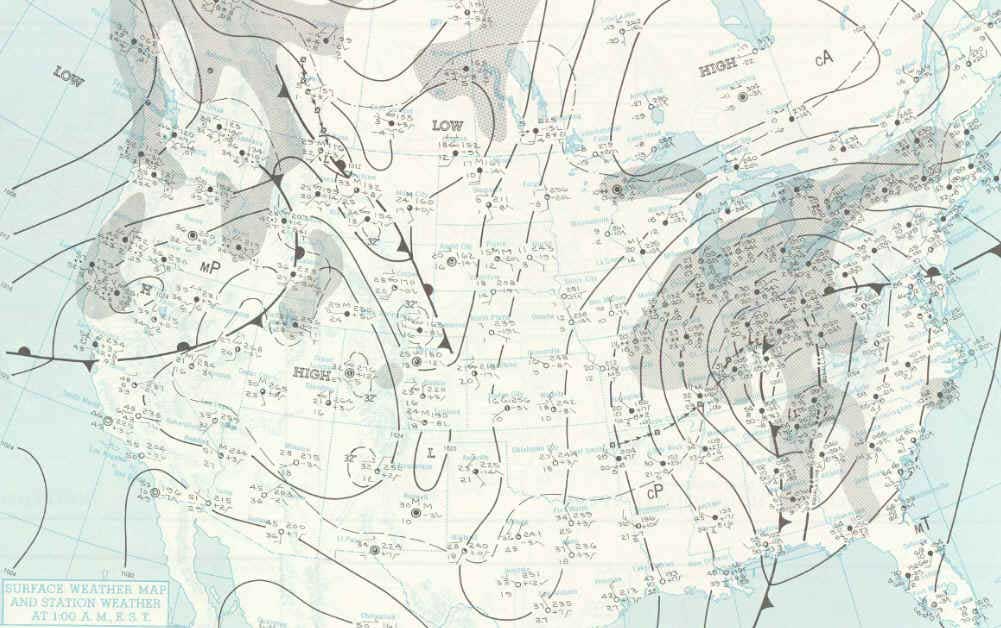
The Meteorology
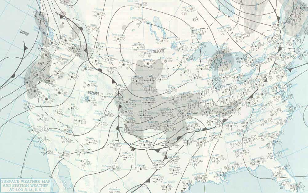
On Wednesday January 25 a cold front had moved through the upper Midwest replacing the balmy 60 degree weather of the previous day with more seasonal readings. A strong 1032mb (30.48 in) high pressure center was over the prairie provinces of southern Canada. A vigorous upper level trough was moving across the southern Rockies causing a low pressure area to form at the surface near the Texas Panhandle. By midnight of Thursday January 26 the high was building into the northern plains states while the low, now at 1008mb (29.77 in) continued to develop and move east to Oklahoma. During the day Thursday the upper trough moved through the mid and lower Mississippi Valley and an upper level low began forming near the Missouri/Arkansas border. The surface low moved through Arkansas and western Tennessee and Kentucky, reaching south central Indiana by midnight Friday. The low deepened rapidly to 997mb (29.44 in) as it moved to Indiana.
Dew points in the 50s to lower 60s over the southern plains and Gulf Coast states fed the storm with ample moisture while the Canadian high pressure, now centered over Lake Superior and southern Ontario, kept cold dry air pouring into the Great Lakes. The strong pressure gradient between the high over the upper Lakes and the deepening low over the Ohio Valley caused winds to howl off Lake Michigan. This produced severe blowing and drifting of snow as well as causing lake effect enhancement of the snowfall.
On Friday the upper low continued to form and move northeast to northwest Ohio. The surface low occluded and deepened to 990mb (29.23 in) as it lifted northeast across Lake Erie and into southeast Ontario, Canada by Friday night. By this time the snow had ended in Chicago and winds shifted to north northwest and began to subside.

The Forecast
Issued at 945 AM Wednesday January 25th
Thursday…Cloudy with a chance of snow especially in the afternoon. High near 30. Northeast winds 8 to 15 mph. Chance of precipitation 50 percent.
Issued at 345 PM Wednesday January 25th
Thursday…Cloudy with rain or snow likely. High in the 30s. Northeast to east winds 10 to 18 mph. Chance of precipitation 50 percent.
Thursday Night…Rain or snow likely. Low in the lower 30s. Chance of precipitation 50 percent.
Friday…Rain or snow ending.
Issued 945 PM Wednesday January 25th
…Hazardous Driving Warning late tonight and Thursday…
Remainder of tonight…Cloudy and colder with snow possibly mixed with freezing rain beginning late tonight. Low in the upper 20s. Chance of precipitation 50 percent.
Thursday…Snow mixed with freezing rain likely. High in the lower 30s. Northeast to east winds 10 to 20 mph. Chance of precipitation greater than 90 percent.
Thursday Night…Snow or rain changing to snow and turning colder. Low near 20. Chance of precipitation greater than 90 percent.
Friday…Partly cloudy and colder.
Issued at 345 AM Thursday January 26
…Heavy Snow Warning…
Today…Snow with accumulations of 4 inches or more by this afternoon. High in the lower 30s. Northeast winds 15 to 25 mph. Chance of precipitation greater than 90 percent.
Tonight…Snow diminishing or ending. Colder with the low near 20. North to northeast winds 15 to 25 mph. Chance of precipitation 80 percent.
Friday…Partly cloudy and colder. High in the mid 20s. Chance of precipitation 20 percent.
Issued at 945 AM Thursday January 26
…Heavy Snow Warning…
Today…An additional 4 to 8 inches. Windy with steady temperatures. Northeast winds 25 to 35 mph. Chance of precipitation 100 percent.
Tonight…Snow diminishing and ending. Colder with the low 10 to 15. North to northwest winds 15 to 30 mph. Chance of precipitation 50 percent.
Friday…Partly cloudy and colder. High in the middle 20s. Northwest winds 12 to 22 mph. Chance of precipitation 20 percent.
Over the last half century, the advent of high resolution numerical weather prediction models, advanced GOES satellite technology, Doppler radar, and a dense network of automated surface observations has allowed forecasters to give much more accurate warnings of snow storms with much greater lead time, which enabled, for instance, a much longer advanced notice and preparation time for the 2011 Groundhog Day Blizzard. Despite the infamous photos of cars standed on a snowbound Lakeshore Drive, similar scenes were far more isolated after the Groundhog Day Blizzard. This is because the blizzard warnings were heeded and many businesses were closed before or as the snow started, so many people stayed home or left work early enough to return home safely.
The Record Book
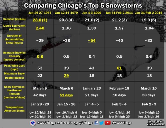
Greatest snowfall from a storm – 23.0 inches January 26-27, 1967.
At the time, greatest snowfall in a calendar day – 16.4 inches on January 26, 1967 (this was surpassed when 18.6 inches fell on January 2, 1999).
At the time, greatest snowfall in a 24 hour period – 19.8 inches January 26-27, 1967 (surpassed by Groundhog Day Blizzard 1/31-2/2/11: 20.0 inches February 1-2, 2011).
At the time, greatest snow depth – Additional snows brought the snow depth to 27 inches by February 6, 1967. (This was surpassed when 29 inches covered the ground January 14, 1979) A total of 36.5 inches of snow fell on the city during the 11-day period from January 26 through February 5, 1967, which is close to normal snowfall for an entire season! Snow covered the ground until March 10.
At the time, greatest snowfall for a season – The winter of 1966-1967 set the record for Chicago with a total of 68.4 inches. (The record has since been surpassed four times).