


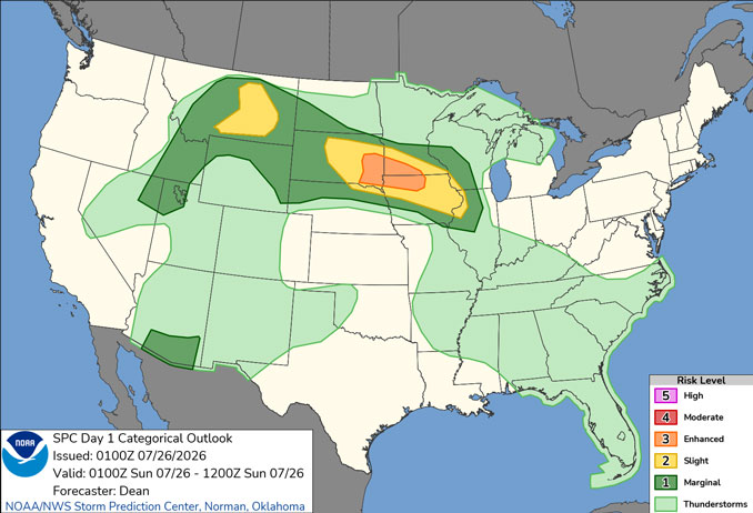
CHICAGOLAND DETAILS …
Radar is clear in northern Illinois Saturday at 9:20 p.m.
The Air Quality Index is in the Moderate (Yellow) category for PM2.5. After being in the Green (Good) category from midnight to 3:00 p.m. Saturday, the AQI has increased into the Moderate (Yellow) category Saturday evening, and is expected to remain in the Moderate (Yellow) category Sunday.
Relative Humidity will increase overnight reaching 100% about 5:00 a.m. after the daytime Saturday already gradually felt muggy as the day wore on. Fog is only expected southwest of Chicago in areas such as Joliet and Naperville overnight.
Heat and humidity returns tomorrow and into Monday. In the absence of storms, peak heat indices Monday of 105+ are possible.
Potential for a few storms Sunday morning, mainly west of the Fox Valley. Additional storms–some of which may be strong to severe–remain possible late Sunday afternoon and overnight.
Severe threat continues on Monday and Monday evening before a cold front ushers in less humid conditions for the rest of the week.
See also: LIVE STREAMS: Arlingtoncardinal.com/StormChasers
Temperature Outlook …
SU 70 92 | M 75 92 | T 72 83 | W 65 82
O’HARE FORECAST …
Saturday Night: Mostly cloudy, with a low around 70. South southwest wind around 5 mph.
Sunday: Partly sunny, with a high near 92. Heat index values as high as 98. Southwest wind 5 to 10 mph, with gusts as high as 20 mph.
Sunday Night: A 40 percent chance of showers and thunderstorms, mainly after 10pm. Mostly cloudy, with a low around 75. Southwest wind 5 to 10 mph, with gusts as high as 20 mph.
Monday: A 50 percent chance of showers and thunderstorms. Mostly sunny, with a high near 92. Heat index values as high as 103. South wind 5 to 15 mph becoming west southwest in the afternoon. Winds could gust as high as 20 mph.
Monday Night: A 30 percent chance of showers and thunderstorms before 1am. Partly cloudy, with a low around 72. West southwest wind around 10 mph becoming north northwest after midnight. Winds could gust as high as 15 mph.
Tuesday: Mostly sunny, with a high near 83.
Tuesday Night: Mostly clear, with a low around 65.
Wednesday: Sunny, with a high near 82.
Wednesday Night: Mostly clear, with a low around 65.
Thursday: Sunny, with a high near 86.
Thursday Night: Partly cloudy, with a low around 68.
Friday: Mostly sunny, with a high near 86.
Friday Night: A chance of showers. Partly cloudy, with a low around 69.
RADAR • Clouds • Temps • NWS CHGO • UV

PHOENIX FORECAST …
Extreme Heat Warning until July 27, 08:00 PM MST
Saturday Night: A 10 percent chance of showers and thunderstorms before 10pm. Mostly cloudy, with a low around 94. East wind 5 to 10 mph becoming west after midnight.
Sunday: Mostly sunny and hot, with a high near 110. Heat index values as high as 113. West wind 5 to 10 mph.
Sunday Night: Mostly cloudy, with a low around 91. West wind around 5 mph.
Monday: Mostly sunny, with a high near 109. West wind 5 to 10 mph.
Monday Night: A 10 percent chance of showers and thunderstorms after 11pm. Partly cloudy, with a low around 90. West southwest wind around 5 mph.
Tuesday: A 10 percent chance of showers and thunderstorms before 11am. Mostly sunny, with a high near 109. West wind 5 to 10 mph.
Tuesday Night: Partly cloudy, with a low around 89. West wind around 5 mph.
Wednesday: Mostly sunny, with a high near 109. Calm wind becoming west around 5 mph in the afternoon.
Wednesday Night: Partly cloudy, with a low around 91. West wind around 5 mph.
Thursday: Mostly sunny and hot, with a high near 112. West wind 5 to 10 mph.
Thursday Night: Mostly clear, with a low around 92. West southwest wind around 5 mph.
Friday: Mostly sunny and hot, with a high near 113. West southwest wind 5 to 10 mph.
Friday Night: A 10 percent chance of showers and thunderstorms. Partly cloudy, with a low around 93. West southwest wind around 5 mph.
RADAR • Clouds • Temps • NWS Phoenix • UV

MIAMI FORECAST …
Saturday Night: Partly cloudy, with a low around 79. Light southwest wind.
Sunday: Showers and thunderstorms. Some of the storms could produce heavy rainfall. High near 91. Heat index values as high as 106. Light and variable wind becoming southwest 5 to 8 mph in the morning. Chance of precipitation is 80%. New rainfall amounts between a half and three quarters of an inch possible.
Sunday Night: Showers and thunderstorms likely, mainly before 2am. Mostly cloudy, with a low around 78. West wind around 5 mph. Chance of precipitation is 60%. New rainfall amounts between a quarter and half of an inch possible.
Monday: Showers and thunderstorms likely, mainly after 2pm. Mostly sunny, with a high near 91. Heat index values as high as 106. West wind 5 to 8 mph. Chance of precipitation is 70%.
Monday Night: Showers likely and possibly a thunderstorm before 8pm, then scattered showers and thunderstorms between 8pm and 2am. Mostly cloudy, with a low around 79. West wind 5 to 7 mph. Chance of precipitation is 60%.
Tuesday: Showers and thunderstorms likely, mainly after 2pm. Partly sunny, with a high near 91. Southwest wind 6 to 11 mph, with gusts as high as 18 mph. Chance of precipitation is 70%.
Tuesday Night: Showers and thunderstorms likely, mainly before 8pm. Partly cloudy, with a low around 79. Southwest wind 6 to 9 mph. Chance of precipitation is 60%.
Wednesday: A 30 percent chance of showers and thunderstorms after 8am. Mostly sunny, with a high near 92. Southwest wind 7 to 14 mph, with gusts as high as 20 mph.
Wednesday Night: Partly cloudy, with a low around 80. Southwest wind 7 to 10 mph.
Thursday: A 20 percent chance of showers and thunderstorms after 2pm. Mostly sunny, with a high near 93.
Thursday Night: Partly cloudy, with a low around 80.
Friday: A 20 percent chance of showers and thunderstorms. Mostly sunny, with a high near 93.
Friday Night: A 10 percent chance of showers and thunderstorms. Partly cloudy, with a low around 80.
RADAR • Clouds • Temps • NWS Miami • UV
LAX FORECAST …
Heat Advisory until July 27, 08:00 PM PDT
Beach Hazards Statement until July 29, 06:00 PM PDT
Saturday Night: Patchy fog after 11pm. Otherwise, increasing clouds, with a low around 70. South southwest wind 5 to 10 mph.
Sunday: Patchy fog before 11am. Otherwise, cloudy, then gradually becoming mostly sunny, with a high near 82. Light and variable wind becoming west southwest 5 to 10 mph in the morning. Winds could gust as high as 15 mph.
Sunday Night: Patchy fog after 11pm. Otherwise, increasing clouds, with a low around 69. West southwest wind 5 to 10 mph becoming southeast after midnight.
Monday: Patchy fog before 11am. Otherwise, cloudy through mid morning, then gradual clearing, with a high near 82. Southeast wind 5 to 10 mph becoming southwest in the afternoon. Winds could gust as high as 15 mph.
Monday Night: Patchy fog after 11pm. Otherwise, mostly cloudy, with a low around 69. Southwest wind 5 to 10 mph becoming east southeast after midnight. Winds could gust as high as 15 mph.
Tuesday: Patchy fog before 11am. Otherwise, mostly sunny, with a high near 80.
Tuesday Night: Mostly clear, with a low around 68.
Wednesday: Mostly sunny, with a high near 80.
Wednesday Night: Mostly clear, with a low around 68.
Thursday: Mostly sunny, with a high near 80.
Thursday Night: Mostly clear, with a low around 68.
Friday: Mostly sunny, with a high near 82.
Friday Night: Mostly clear, with a low around 68.
RADAR • Clouds • Temps • NWS Los Angeles • UV
WASH DC FORECAST …
Saturday Night: Mostly clear, with a low around 66. Southeast wind around 6 mph becoming calm in the evening.
Sunday: Patchy fog before 7am. Otherwise, mostly sunny, with a high near 86. Calm wind becoming east around 5 mph in the afternoon.
Sunday Night: A chance of showers and thunderstorms, mainly between 8pm and 2am. Partly cloudy, with a low around 68. Southeast wind around 5 mph becoming calm in the evening. Chance of precipitation is 30%.
Monday: A chance of showers and thunderstorms after 2pm. Mostly sunny, with a high near 89. Calm wind becoming southwest around 6 mph in the afternoon. Chance of precipitation is 50%.
Monday Night: A chance of showers and thunderstorms before 8pm, then showers likely and possibly a thunderstorm between 8pm and 2am, then a chance of showers after 2am. Mostly cloudy, with a low around 70. South wind 3 to 5 mph. Chance of precipitation is 60%.
Tuesday: Showers likely, then showers and possibly a thunderstorm after 11am. High near 87. Chance of precipitation is 80%.
Tuesday Night: Showers and possibly a thunderstorm before 8pm, then a chance of showers and thunderstorms between 8pm and 2am, then a slight chance of showers after 2am. Low around 69. Chance of precipitation is 80%.
Wednesday: A slight chance of showers, then a chance of showers and thunderstorms after 2pm. Partly sunny, with a high near 86. Chance of precipitation is 30%.
Wednesday Night: A chance of showers and thunderstorms before 8pm. Partly cloudy, with a low around 67. Chance of precipitation is 30%.
Thursday: Mostly sunny, with a high near 86.
Thursday Night: Partly cloudy, with a low around 68.
Friday: A slight chance of showers and thunderstorms. Mostly sunny, with a high near 89. Chance of precipitation is 20%.
Friday Night: Partly cloudy, with a low around 70.
Baltimore/Washington DC Forecast
RADAR • Clouds • Temps • NWS Baltimore/Washington • UV
O’Hare Weather Forecast Compared to Phoenix, Miami, LA, Wash DC SAT JUL 25, 2026 9:16 PM SOURCE: National Weather Service local offices.
