
CHICAGOLAND DETAILS …
Radar was clear in northeast Illinois last night around midnight, but precipitation as showers and thunderstorms approached in eastern Iowa and western Wisconsin.
Trending warmer and more humid with periods of showers and thunderstorms starting early Friday and continuing into next
week. Uncertainty exists when the rain will begin near O’Hare. Storms are drifting by to the northeast as they slowly move eastward. There will likely be some sprinkles or periodic light showers before noon, and then steadier rainfall periods after noon until about 4:00 pm. Then periodic showers are possible though Sunday with a lot of dry periods between showers.
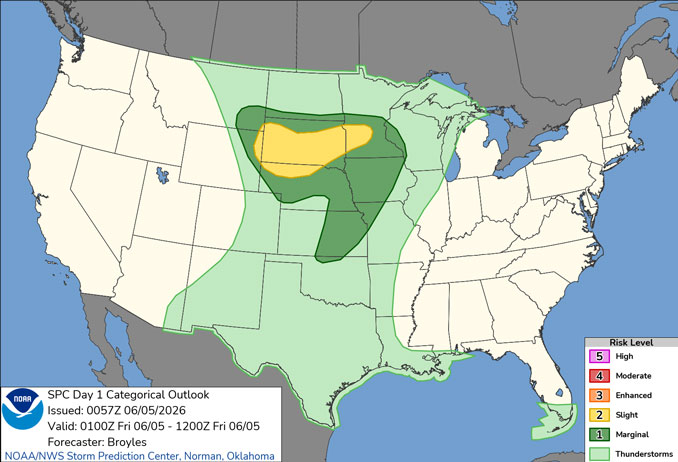
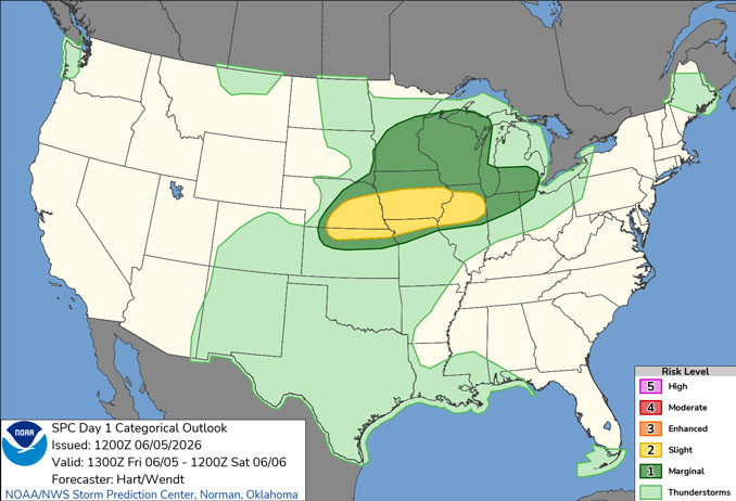
Low (level 1 out of 5) severe weather threat Friday PM along with a threat for locally heavy rainfall.
This midnight report was updated at 7:30 am Friday.
See also: LIVE STREAMS: Arlingtoncardinal.com/StormChasers
O’HARE FORECAST …
Thursday Night: A 10 percent chance of showers and thunderstorms after 5am. Mostly cloudy, with a low around 68 about 6am. South southwest wind around 10 mph, with gusts as high as 20 mph.
Friday: A chance of showers and thunderstorms before noon, then showers likely and possibly a thunderstorm between noon and 4pm, then a chance of showers and thunderstorms after 4pm. Mostly cloudy, with a high near 83 about 4pm. Breezy, with a south southwest wind 10 to 20 mph, with gusts as high as 30 mph. Chance of precipitation is 70%. New rainfall amounts between a quarter and half of an inch possible.
Friday Night: A chance of showers and thunderstorms before 4am, then a slight chance of showers after 5am. Increasing clouds, with a low around 67. Southwest wind 10 to 15 mph, with gusts as high as 25 mph. Chance of precipitation is 30%.
Saturday: A 50 percent chance of showers and thunderstorms, mainly after 7am. Partly sunny, with a high near 84. Southwest wind 5 to 10 mph.
Saturday Night: A 20 percent chance of showers after 1am. Partly cloudy, with a low around 64. East northeast wind around 5 mph.
Sunday: Partly sunny, with a high near 81.
Sunday Night: A 20 percent chance of showers and thunderstorms after 1am. Mostly cloudy, with a low around 64.
Monday: A chance of showers and thunderstorms after 1pm. Mostly cloudy, with a high near 85.
Monday Night: A chance of showers and thunderstorms. Mostly cloudy, with a low around 68.
RADAR • Clouds • Temps • NWS CHGO • UV

PHOENIX FORECAST …
Overnight Thursday/Friday: Clear, with a low around 79. West wind 5 to 10 mph becoming light southwest after midnight. Winds could gust as high as 20 mph.
Friday: Sunny, with a high near 107. Light and variable wind becoming west 5 to 10 mph in the afternoon. Winds could gust as high as 20 mph.
Friday Night: Clear, with a low around 78. Breezy, with a west wind 10 to 15 mph becoming light and variable after midnight. Winds could gust as high as 25 mph.
Saturday: Sunny, with a high near 106. Light and variable wind becoming west southwest 5 to 10 mph in the afternoon. Winds could gust as high as 20 mph.
Saturday Night: Partly cloudy, with a low around 76. Breezy, with a west southwest wind 10 to 15 mph becoming light and variable after midnight. Winds could gust as high as 25 mph.
Sunday: Sunny, with a high near 103. Southeast wind 5 to 10 mph becoming west southwest in the afternoon. Winds could gust as high as 20 mph.
Sunday Night: Mostly clear, with a low around 74. West southwest wind 5 to 10 mph becoming light and variable in the evening. Winds could gust as high as 20 mph.
Monday: Sunny, with a high near 104. Calm wind becoming south around 5 mph in the morning.
Monday Night: Clear, with a low around 74. West wind 5 to 10 mph becoming light and variable in the evening. Winds could gust as high as 20 mph.
RADAR • Clouds • Temps • NWS Phoenix • UV

MIAMI FORECAST …
Rip Current Statement
Coastal Hazard Message
129 AM EDT Fri Jun 5 2026
HIGH RIP CURRENT RISK NOW IN EFFECT THROUGH SATURDAY EVENING for Coastal Broward County-Coastal Miami Dade County
Overnight Thursday/Friday: Isolated showers before 1am. Mostly cloudy, with a low around 76. East wind around 11 mph, with gusts as high as 20 mph. Chance of precipitation is 20%.
Friday: Partly sunny, with a high near 84. East wind 11 to 14 mph, with gusts as high as 20 mph.
Friday Night: Partly cloudy, with a low around 76. East wind around 9 mph.
Saturday: Mostly sunny, with a high near 86. East wind 9 to 13 mph, with gusts as high as 20 mph.
Saturday Night: Scattered showers and thunderstorms, mainly after 2am. Partly cloudy, with a low around 77. East wind 7 to 10 mph. Chance of precipitation is 30%.
Sunday: Scattered showers and thunderstorms, mainly before 8am. Mostly sunny, with a high near 87. East wind 6 to 11 mph. Chance of precipitation is 30%.
Sunday Night: A 20 percent chance of showers and thunderstorms after 8pm. Mostly cloudy, with a low around 78. Southeast wind 6 to 9 mph.
Monday: A 40 percent chance of showers and thunderstorms, mainly after 2pm. Partly sunny, with a high near 88. Southeast wind 5 to 10 mph.
Monday Night: A 40 percent chance of showers and thunderstorms. Mostly cloudy, with a low around 78. East wind 6 to 9 mph.
RADAR • Clouds • Temps • NWS Miami • UV

LAX FORECAST …
Overnight Thursday/Friday: Patchy fog before 11pm. Otherwise, cloudy, with a low around 61. Southwest wind around 5 mph.
Friday: Cloudy through mid morning, then gradual clearing, with a high near 70. Light southwest wind becoming west 5 to 10 mph in the afternoon. Winds could gust as high as 15 mph.
Friday Night: Patchy fog after 11pm. Otherwise, mostly cloudy, with a low around 62. South wind 5 to 10 mph, with gusts as high as 15 mph.
Saturday: Patchy fog before 11am. Otherwise, cloudy, with a high near 69. South southeast wind 5 to 15 mph becoming southwest in the afternoon.
Saturday Night: Patchy fog. Otherwise, cloudy, with a low around 60. West southwest wind 5 to 15 mph becoming southeast after midnight.
Sunday: Patchy fog before 11am. Otherwise, mostly sunny, with a high near 68.
Sunday Night: Mostly clear, with a low around 59.
Monday: Mostly sunny, with a high near 73.
Monday Night: Mostly clear, with a low around 60.
RADAR • Clouds • Temps • NWS Los Angeles • UV

WASH DC FORECAST …
Air Quality Alert
District of Columbia-
440 PM EDT Thu Jun 4 2026
AIR QUALITY ALERT IS IN EFFECT FOR FRIDAY JUNE 5 2026…
The Metropolitan Washington Council of Governments and District Department of Environment has issued a Code ORANGE Air Quality Alert Friday for the District of Columbia.
A Code Orange Air Quality Alert means that air pollution concentrations within the region may become unhealthy for
sensitive groups. Sensitive groups include children, people suffering from asthma, heart disease or other lung diseases and
the elderly. The effects of air pollution can be minimized by avoiding strenuous activity or exercise outdoors.
NOTE: The alert did not indicate the specific pollutant. AirNOW.gov indicates the pollutant is PM2.5, which refers to microscopic airborne particles measuring 2.5 micrometers or less in diameter.
Overnight Thursday/Friday: Mostly clear, with a low around 64. Light southwest wind.
Friday: Mostly sunny, with a high near 93. Calm wind becoming southwest around 5 mph in the afternoon.
Friday Night: Partly cloudy, with a low around 69. Light south wind.
Saturday: Mostly cloudy, then becoming sunny during the afternoon, with a high near 94. Light southwest wind becoming west 6 to 11 mph in the morning. Winds could gust as high as 21 mph.
Saturday Night: A chance of showers and thunderstorms. Partly cloudy, with a low around 71. West wind 3 to 7 mph. Chance of precipitation is 30%.
Sunday: Mostly sunny, with a high near 91.
Sunday Night: Mostly clear, with a low around 68.
Monday: Sunny, with a high near 84.
Monday Night: Mostly clear, with a low around 58.
RADAR • Clouds • Temps • NWS Baltimore/Washington • UV
O’Hare Weather Forecast Compared to Phoenix, Miami, LA, Wash DC THU JUN 04, 2026 11:45 PM SOURCE: National Weather Service local offices.
