
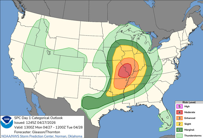

There is a threat for severe weather today, primarily between 4pm and 11pm Monday evening. The main threats are damaging winds and damaging hail. However, the greater risk for severe weather exists in Central Illinois and Southern Illinois. The probability of damaging thunderstorm winds in the Arlington Heights area is lower (at 15%) and the probability of hail is also low (at 5%). The probability of a tornado in the northwest suburbs is also low (at 5%). The probability of a tornado in Illinois is greatest in southwest Illinois (at 15%).
Rainfall greater than one-half inch is likely Monday between 11am and midnight Monday/Tuesday. The most intense thunder and lightning for Monday near downtown Arlington Heights is likely about 7pm to 9pm.
There is a low chance (10 to 20%) of damaging non-thunderstorm wind gusts today (before thunderstorms arrive) north of I-80 between noon and 3pm Monday.
A transition toward a cooler and drier pattern will commence by midweek with highs in the upper 40s and 50s and lows in the upper 30s and 40s through Saturday.
Weather Radarat at 8:40 a.m. shows precipitation ahead of the main precipitation reaching upward toward the northwest suburbs with an estimated arrival time in downtown Arlington Heights at about 9:15 a.m. to 9:20 a.m.
See also Arlingtoncardinal.com/clouds
ARL HTS FORECAST …
Monday: A chance of showers before noon, then showers likely and possibly a thunderstorm between noon and 3pm, then a chance of showers after 3pm. Cloudy, with a high near 66. Breezy, with a south southeast wind 15 to 20 mph, with gusts as high as 40 mph. Chance of precipitation is 70%. New rainfall amounts between a quarter and half of an inch possible.
Monday Night: Showers and possibly a thunderstorm before midnight, then a slight chance of showers between midnight and 1am. Low around 51. Breezy, with a southwest wind 15 to 20 mph, with gusts as high as 35 mph. Chance of precipitation is 80%. New precipitation amounts between a quarter and half of an inch possible.
Tuesday: Partly sunny, with a high near 62. West wind 10 to 15 mph, with gusts as high as 25 mph.
Tuesday Night: A 20 percent chance of showers after 1am. Mostly cloudy, with a low around 46. North wind around 5 mph, with gusts as high as 10 mph.
Wednesday: Partly sunny, with a high near 57. North wind 10 to 15 mph.
Wednesday Night: Partly cloudy, with a low around 40.
Thursday: Partly sunny, with a high near 57.
Thursday Night: Mostly cloudy, with a low around 39.
Friday: Mostly sunny, with a high near 54.
Friday Night: Partly cloudy, with a low around 38.
Saturday: Sunny, with a high near 60.
Saturday Night: Partly cloudy, with a low around 42.
Sunday: Mostly sunny, with a high near 69.
LAKE TEMPS …
Southern Lake Michigan Water Temperatures
National Weather Service Chicago/Romeoville IL
909 AM CDT Sun Apr 26 2026
Lake Michigan Water Temperatures…
Chicago Shore………..53.
Chicago Crib…………50.
Waukegan Buoy………..46.
Winthrop Harbor Buoy….47.
Michigan City………..49.
South Mid Lake Buoy…..39.
&&
M is for missing data that is normally available. Chicago Shore,
Chicago Crib, and Michigan City are read every day of the year.
Measured at a depth of 60 ft for Chicago Crib and 30 ft for
Michigan City. May not represent surface temperature.
april.chicagoweatherstation.com
Chicago Weather Forecast for your MAC/PC/TABLET includes surrounding suburbs.
^^ MOBILE? USE VOICE MIC ^^
facebook …
Please ‘LIKE’ the ‘Arlington Cardinal Page. See all of The Cardinal Facebook fan pages at Arlingtoncardinal.com/about/facebook …
Help fund The Cardinal Arlingtoncardinal.com/sponsor
