
Flash Flood Warning already exists for areas near Peoria and Pontiac. Most of Northern Illinois except for northern tier counties (Lake, McHenry, etc) are under a Flash Flood Watch.
At about 7:05 p.m. Tuesday, heavy thunderstorms, indicated by radar [LIVE RADAR] are on the move east-northeast at about Interstate 80 — covering the western half of Illinois from Starved Rock to the Mississippi River.
Another area of more severe storms are on the move in Iowa, and seem to be training in Iowa — also moving east-northeast on a more northerly track.
The most severe weather in Chicagoland could be along a path including Naperville, Wheaton, Schaumburg, Elmhurst, and Oak Lawn; but it is too early to tell, and the system could move north as a warm front moves north.
The air is very humid with dew point readings in the upper 60s and some 70s. Thunderstorm cells are expected to develop overnight and may involve heavy rain up to 2 inches per hour, and if thunderstorm cell training occurs, some areas may get 5 inches of rain.
FLASH FLOOD WATCH
NATIONAL WEATHER SERVICE CHICAGO/ROMEOVILLE IL
628 PM CDT TUE MAY 28 2013
OGLE-DE KALB-KANE-DUPAGE-COOK-KENDALL-WILL-LAKE IN-PORTER-NEWTON-
JASPER-BENTON-
INCLUDING THE CITIES OF…OREGON…DEKALB…AURORA…WHEATON…
CHICAGO…OSWEGO…JOLIET…GARY…VALPARAISO…MOROCCO…
RENSSELAER…FOWLER
628 PM CDT TUE MAY 28 2013 /728 PM EDT TUE MAY 28 2013/
…FLASH FLOOD WATCH IN EFFECT THROUGH WEDNESDAY MORNING…
THE NATIONAL WEATHER SERVICE IN CHICAGO HAS EXPANDED THE
* FLASH FLOOD WATCH TO INCLUDE MUCH OF NORTHERN AND CENTRAL
ILLINOIS AND NORTHWEST INDIANA.
* UNTIL 10 AM WEDNESDAY MORNING.
* PERIODS OF SHOWERS AND THUNDERSTORMS ARE LIKELY TONIGHT INTO
WEDNESDAY MORNING. DUE TO THE VERY MOIST AIRMASS IN PLACE SOME
OF THE THUNDERSTORMS COULD PRODUCE TORRENTIAL RAINFALL WITH
RATES OF OVER TWO INCHES PER HOUR POSSIBLE. IN
ADDITION…CONDITIONS APPEAR FAVORABLE FOR THUNDERSTORMS TO
REPEATEDLY MOVE OVER THE SAME AREAS TONIGHT RESULTING IN LOCALLY
EXTREME RAINFALL TOTALS WHICH COULD RESULT IN SIGNIFICANT FLASH
FLOODING.
* DUE TO THE ELEVATED RISK OF FLASH FLOODING…POTENTIALLY
BECOMING LOCALLY SIGNIFICANT OVERNIGHT…PERSONS IN FLOOD PRONE
AND LOW LYING AREAS SHOULD CLOSELY MONITOR LATER STATEMENTS AND
POSSIBLE WARNINGS.
PRECAUTIONARY/PREPAREDNESS ACTIONS…
A FLASH FLOOD WATCH MEANS THAT CONDITIONS MAY DEVELOP THAT LEAD
TO FLASH FLOODING. FLASH FLOODING IS A VERY DANGEROUS SITUATION.
YOU SHOULD MONITOR LATER FORECASTS AND BE PREPARED TO TAKE ACTION
SHOULD FLASH FLOOD WARNINGS BE ISSUED.
Chicagoland is also in a risk area for tornados, according to the National Weather Service Storm Predictions Center …
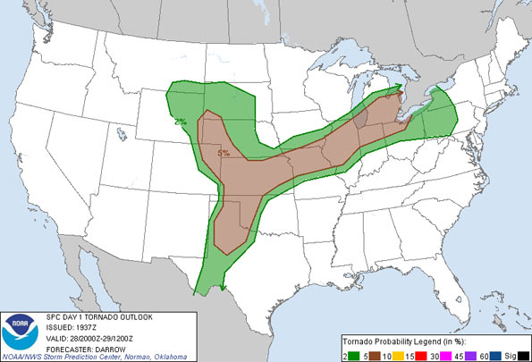
Kansas, much of Missouri, and much of Illinois including Chicagoland share the same risk area. The elevated tornado risk is valid until 6:00 a.m. CDT Wednesday May 29, 2013.
Become a fan of The Cardinal weather page. Submit your pictures or just stay up-to-date on weather topics — go direct to the Arlington Cardinal Weather photos. For a list of all of The Cardinal Facebook fan pages, go to Arlingtoncardinal.com/about/facebook …
