
Thunderhead and back side of storm in Lake County, while towering over the intersection of Arlington Heights Road and Palatine Road. The storm caused activation of a Tornado Warning from the National Weather Service Chicago as it passed across McHenry County and Lake County.
A second large area of diminishing storms dropped down from Lake County and McHenry County shortly after 10:30 p.m., entering Cook County about 10:30 p.m. A Severe Thunderstorm Warning was issued about 10:20 p.m. Thursday.
An earlier storm caused the National Weather Service Chicago to issue a Tornado Warning. Initially no injuries were reported and no severe damage after a thunderstorm cell popped up just before 6:50 p.m. Thursday. The National Weather Service Chicago issued a Tornado Warning for southeast McHenry County, north central Cook County, and Lake County at 6:53 p.m.
The southern tip of the storm cell did not cross into Cook County where the northernmost neighborhood in Arlington Heights is at the border of Lake County and Cook County at Lake-Cook Road. The thunderstorm cell was moving west to east across McHenry County and Lake County.
People in Arlington Heights turned heads up to the sky to the north around sunset, watching the thunderstorm tops soar to a very high angle in the sky — complete with lightning in clouds and lightning strikes to the ground on the north horizon.
A tornado signature on radar was detected about 6:53 p.m. Thursday September 11, 2019, and some people may have captured tornado rotation images. Initially no tornado touchdowns were reported Wednesday night.
WOW! Rotation over Wauconda earlier this evening. @fox32news pic.twitter.com/KcPh5JphgV
— Bill Bellis FOX 32 (@BillBellis) September 12, 2019
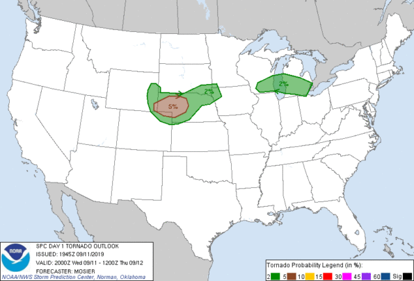
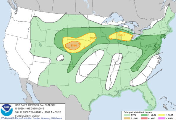
The Probabilistic Tornado Graphic for the time period encompassing the time the Tornado Warning was issued projected a 2% tornado zone in southern Wisconsin and southern Michigan, but did not have a tornado zone in Illinois. The Tornado Outlook and Categorical Outlook below were issued at 2:45 p.m. Thursday.
A smaller storm cell with cloud-to-ground lightning also moved from west to east about 8:10 p.m. near Dundee Road.
There were technical difficulties with the National Weather Service forecast pages Thursday night. Attempts to reach city forecasts failed with either blank pages with reference numbers, or forecasts with blank fields for current observations.
^^ MOBILE? USE VOICE MIC ^^
facebook …
Please ‘LIKE’ the ‘Arlington Cardinal Page. See all of The Cardinal Facebook fan pages at Arlingtoncardinal.com/about/facebook …
Help fund The Cardinal Arlingtoncardinal.com/sponsor
20240105-1435future
THANKS FOR READING CARDINAL NEWS
