


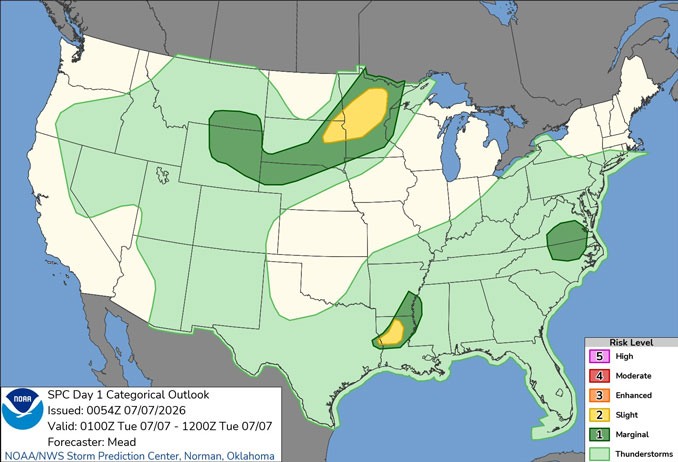
CHICAGOLAND DETAILS …
Radar is clear in northern Illinois around midnight Monday to Tuesday.
Dry and more seasonable conditions expected through Wednesday before shower and thunderstorm chances return Thursday.
A corridor of heavy rainfall may occur somewhere in the region Thursday-Friday, though confidence in whether impacts occur locally remains low.
See also: LIVE STREAMS: Arlingtoncardinal.com/StormChasers
Temperature Outlook …
T 64 84 | W 67 87 | R 71 84 | F 68 80
O’HARE FORECAST …
Overnight: Mostly clear, with a low around 64. North wind around 5 mph.
Tuesday: Sunny, with a high near 84. North wind around 5 mph becoming east in the afternoon.
Tuesday Night: Mostly clear, with a low around 67. East wind around 5 mph becoming calm in the evening.
Wednesday: Mostly sunny, with a high near 87. Southwest wind 5 to 10 mph.
Wednesday Night: Partly cloudy, with a low around 71. Southwest wind 5 to 10 mph.
Thursday: A chance of showers and thunderstorms, then showers likely and possibly a thunderstorm after 1pm. Partly sunny, with a high near 84. Chance of precipitation is 70%.
Thursday Night: Showers likely and possibly a thunderstorm before 1am, then a chance of showers and thunderstorms after 1am. Mostly cloudy, with a low around 68. Chance of precipitation is 70%.
Friday: A chance of showers and thunderstorms after 1pm. Partly sunny, with a high near 80.
Friday Night: A chance of showers before 1am. Mostly cloudy, with a low around 66.
Saturday: Mostly sunny, with a high near 84.
Saturday Night: Partly cloudy, with a low around 68.
Sunday: Mostly sunny, with a high near 88.
Sunday Night: Mostly clear, with a low around 70.
RADAR • Clouds • Temps • NWS CHGO • UV

PHOENIX FORECAST …
Extreme Heat Warning in effect from July 7, 10:00 AM MST until July 9, 08:00 PM MST
Air Quality Alert … OZONE HIGH POLLUTION ADVISORY FOR MARICOPA COUNTY INCLUDING THE PHOENIX METRO AREA TUESDAY…
The Arizona Department of Environmental Quality (ADEQ) has issued an
Ozone High Pollution Advisory for the Phoenix Metro Area on Tuesday.
Overnight: Mostly clear, with a low around 87. West northwest wind around 5 mph becoming calm.
Tuesday: Sunny and hot, with a high near 113. Calm wind becoming west around 5 mph in the afternoon.
Tuesday Night: Clear, with a low around 90. West wind around 5 mph becoming calm after midnight.
Wednesday: Sunny and hot, with a high near 113. Light and variable wind becoming west 5 to 10 mph in the afternoon.
Wednesday Night: Clear, with a low around 90. West wind 5 to 10 mph becoming light and variable after midnight.
Thursday: Sunny and hot, with a high near 113. Light and variable wind becoming west 5 to 10 mph in the afternoon. Winds could gust as high as 20 mph.
Thursday Night: Mostly clear, with a low around 88. West southwest wind 5 to 10 mph becoming light and variable after midnight. Winds could gust as high as 20 mph.
Friday: Sunny and hot, with a high near 110. Calm wind becoming west around 5 mph in the afternoon.
Friday Night: Mostly clear, with a low around 87. West southwest wind 5 to 10 mph becoming light west after midnight. Winds could gust as high as 20 mph.
Saturday: Sunny, with a high near 109. Light northwest wind becoming west 5 to 10 mph in the afternoon.
Saturday Night: A 10 percent chance of showers and thunderstorms. Partly cloudy, with a low around 87. West southwest wind 5 to 10 mph becoming light and variable after midnight. Winds could gust as high as 20 mph.
Sunday: Mostly sunny, with a high near 107. North wind 5 to 10 mph becoming southwest in the morning.
Sunday Night: A 40 percent chance of showers and thunderstorms. Mostly cloudy, with a low around 85. West wind around 5 mph becoming calm in the evening.
RADAR • Clouds • Temps • NWS Phoenix • UV

MIAMI FORECAST …
Heat Advisory in effect from July 7, 11:00 AM EDT until July 7, 06:00 PM EDT
Overnight: Mostly cloudy to a frw clouds, with a low around 80. Winds from the east or calm
Tuesday: A 50 percent chance of showers and thunderstorms after 8am. Partly sunny, with a high near 91. Heat index values as high as 106. Calm wind becoming southeast 5 to 9 mph in the afternoon. New rainfall amounts of less than a tenth of an inch, except higher amounts possible in thunderstorms.
Tuesday Night: A 10 percent chance of showers and thunderstorms before 8pm. Partly cloudy, with a low around 82. East wind 3 to 6 mph.
Wednesday: A 10 percent chance of showers and thunderstorms before 7am. Mostly sunny, with a high near 92. Heat index values as high as 109. Southeast wind 6 to 10 mph.
Wednesday Night: Partly cloudy, with a low around 83. East wind around 9 mph.
Thursday: Sunny, with a high near 92. East wind 8 to 11 mph.
Thursday Night: Mostly clear, with a low around 82. Southeast wind 9 to 11 mph, with gusts as high as 20 mph.
Friday: A 30 percent chance of showers and thunderstorms, mainly after 2pm. Mostly sunny, with a high near 92. Southeast wind 9 to 13 mph, with gusts as high as 20 mph.
Friday Night: A 30 percent chance of showers and thunderstorms, mainly before 8pm. Partly cloudy, with a low around 82. Southeast wind 8 to 10 mph.
Saturday: A 20 percent chance of showers and thunderstorms after 2pm. Mostly sunny, with a high near 92. Southeast wind 8 to 10 mph.
Saturday Night: A 10 percent chance of showers and thunderstorms before 8pm. Partly cloudy, with a low around 82.
Sunday: Mostly sunny, with a high near 93.
Sunday Night: Mostly clear, with a low around 82.
RADAR • Clouds • Temps • NWS Miami • UV
LAX FORECAST …
Overnight: Increasing clouds, with a low around 63. South southeast wind around 5 mph.
Tuesday: Patchy fog before 11am. Otherwise, cloudy through mid morning, then gradual clearing, with a high near 75. Light and variable wind becoming west southwest 10 to 15 mph in the morning. Winds could gust as high as 20 mph.
Tuesday Night: Mostly clear, with a low around 64. West southwest wind 5 to 15 mph becoming southeast after midnight. Winds could gust as high as 20 mph.
Wednesday: Mostly sunny, with a high near 76. East southeast wind 5 to 15 mph becoming west southwest in the afternoon.
Wednesday Night: Partly cloudy, with a low around 65. West southwest wind 5 to 15 mph becoming southeast after midnight.
Thursday: Patchy fog before 11am. Otherwise, mostly sunny, with a high near 77.
Thursday Night: Patchy fog after 11pm. Otherwise, mostly cloudy, with a low around 65.
Friday: Patchy fog before 11am. Otherwise, mostly sunny, with a high near 75.
Friday Night: Partly cloudy, with a low around 65.
Saturday: Mostly cloudy, with a high near 74.
Saturday Night: Mostly cloudy, with a low around 65.
Sunday: Mostly cloudy, with a high near 74.
Sunday Night: A slight chance of showers. Mostly cloudy, with a low around 65.
RADAR • Clouds • Temps • NWS Los Angeles • UV
WASH DC FORECAST …
Overnight: Isolated showers and thunderstorms before 5am. Patchy fog before 5am. Otherwise, cloudy, with a low around 73. Northeast wind 3 to 5 mph. Chance of precipitation is 20%.
Tuesday: Isolated showers, then scattered showers and thunderstorms after 11am. Patchy fog before 9am. Otherwise, mostly cloudy, with a high near 85. Calm wind becoming northeast around 5 mph in the afternoon. Chance of precipitation is 30%.
Tuesday Night: Showers and thunderstorms likely before 11pm, then scattered showers. Patchy fog between 11pm and 2am. Otherwise, mostly cloudy, with a low around 69. Light northeast wind. Chance of precipitation is 60%. New precipitation amounts between a tenth and quarter of an inch, except higher amounts possible in thunderstorms.
Wednesday: A chance of showers, mainly before 1pm. Partly sunny, with a high near 84. East wind 3 to 5 mph. Chance of precipitation is 30%.
Wednesday Night: A slight chance of showers and thunderstorms, then showers likely after 2am. Mostly cloudy, with a low around 70. Light south wind. Chance of precipitation is 70%.
Thursday: Showers likely, then showers and possibly a thunderstorm after 11am. High near 87. Chance of precipitation is 90%.
Thursday Night: Showers and possibly a thunderstorm before 8pm, then a chance of showers and thunderstorms between 8pm and 2am. Low around 72. Chance of precipitation is 80%.
Friday: A chance of showers and thunderstorms after 2pm. Mostly sunny, with a high near 91. Chance of precipitation is 40%.
Friday Night: A chance of showers and thunderstorms before 2am, then a slight chance of showers. Mostly cloudy, with a low around 72. Chance of precipitation is 30%.
Saturday: A slight chance of showers, then a chance of showers and thunderstorms after 2pm. Partly sunny, with a high near 87. Chance of precipitation is 40%.
Saturday Night: A chance of showers and thunderstorms. Mostly cloudy, with a low around 69. Chance of precipitation is 30%.
Baltimore/Washington DC Forecast
RADAR • Clouds • Temps • NWS Baltimore/Washington • UV
O’Hare Weather Forecast Compared to Phoenix, Miami, LA, Wash DC TUE JUL 07, 2026 3:03 AM SOURCE: National Weather Service local offices.
