
CHICAGOLAND DETAILS …
Radar indicates precipitation as thundershowers approaching the area, but the thundershowers are diminishing, and may only drop some sprinkles by the time they reach Arlington Heights at about 10:00 a.m. to 10:10 a.m. The former thunderstorms have not produced much lightning since about 8:14 a.m. near Dixon and Mendota, southwest of DeKalb, Illinois.
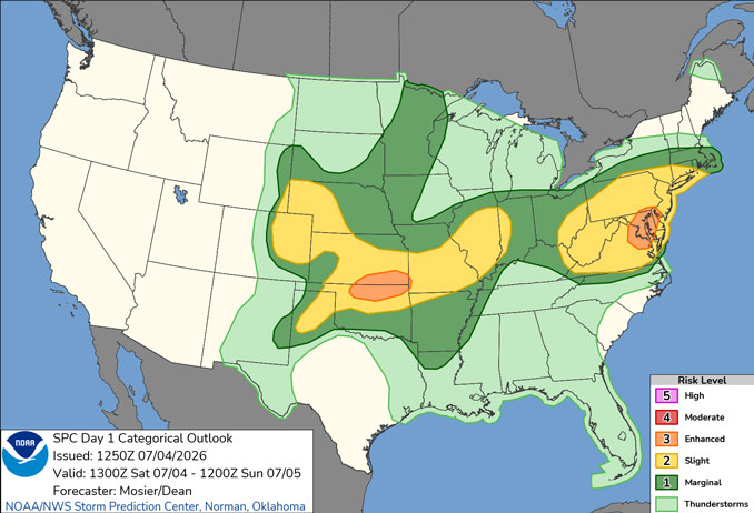
In the afternoon, periods of showers and thunderstorms may re-develop and continue through Saturday and Sunday. There is less potential for storms on Saturday and Sunday, compared to the experience of Thursday and Friday. A few storms could be strong to severe with a threat for damaging winds, especially near and south of I-80.
Locally heavy rainfall will also accompany any thunderstorms and may result in flash flooding especially if storms develop over areas that received heavy rain the past couple days.
Drier and more seasonable conditions expected to start the week before stormier weather returns late week.
See also: LIVE STREAMS: Arlingtoncardinal.com/StormChasers
Temperature Outlook …
SU 68 80 | M 66 80 | T 65 85 | W 68 88
O’HARE FORECAST …
Flood Advisory until July 4, 12:00 PM CDT
Independence Day (Saturday): Showers likely and possibly a thunderstorm before 11am, then showers and thunderstorms likely, mainly after 4pm. Partly sunny, with a high near 83. West northwest wind 5 to 10 mph becoming east southeast in the morning. Chance of precipitation is 60%. New rainfall amounts between a quarter and half of an inch possible.
Saturday Night: Showers and thunderstorms likely, mainly before 7pm. Mostly cloudy, with a low around 68. Northeast wind around 5 mph, with gusts as high as 10 mph. Chance of precipitation is 60%. New rainfall amounts between a tenth and quarter of an inch, except higher amounts possible in thunderstorms.
Sunday: A 30 percent chance of showers and thunderstorms, mainly after 2pm. Partly sunny, with a high near 80. North northeast wind 5 to 10 mph, with gusts as high as 15 mph.
Sunday Night: A slight chance of showers and thunderstorms. Mostly cloudy, with a low around 66. Northeast wind 5 to 10 mph, with gusts as high as 15 mph. Chance of precipitation is 20%.
Monday: Partly sunny, with a high near 80. Northeast wind 5 to 10 mph, with gusts as high as 15 mph.
Monday Night: Partly cloudy, with a low around 65.
Tuesday: Mostly sunny, with a high near 85.
Tuesday Night: Partly cloudy, with a low around 68.
Wednesday: Mostly sunny, with a high near 88.
Wednesday Night: A chance of showers after 1am. Partly cloudy, with a low around 70.
Thursday: A chance of showers and thunderstorms. Mostly sunny, with a high near 87.
Thursday Night: A chance of showers and thunderstorms. Mostly cloudy, with a low around 68.
RADAR • Clouds • Temps • NWS CHGO • UV
O’Hare Weather Forecast SAT JUL 04, 2026 9:05 AM SOURCE: National Weather Service local offices.
