


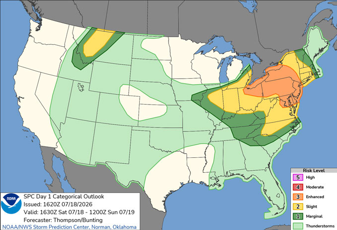
Day 1 Convective Outlook/Categorical for Saturday, July 18, 2026 indicates Level 1 and Level 2/5 risk of severe weather with thunderstorms (SOURCE: NOAA/NWS Storm Prediction Center).
CHICAGOLAND DETAILS …
Radar indicates precipitation in a line of storms that formed south of Arlington Heights, but moved southeast toward the south suburbs of Chicago and Indiana. Additional development likely.
Air Quality Index has improved to “Good” at around 1:00 p.m. Saturday.
Hot and humid conditions continue today with temperatures dropping beginning after 3:00 p.m. Saturday.
Scattered thunderstorms are expected to develop along a cold front this afternoon and evening, some of which could be strong to severe. Highest thunderstorm chances exist near and south of I-80.
Wildfire smoke may return to the area in the wake of the cold front late Saturday and continue into Sunday.
See also: LIVE STREAMS: Arlingtoncardinal.com/StormChasers
Temperature Outlook …
SU 68 81 | M 65 87 | T 71 86 | W 67 77
O’HARE FORECAST …
Beach Hazards Statement in effect from July 18, 07:00 PM CDT until July 19, 10:00 AM CDT
AIR QUALITY ALERT IN EFFECT NOW THROUGH SUNDAY NIGHT for smoke/PM2.5 to a varying degree and duration both later Saturday and Sunday.
Saturday Afternoon: Showers and thunderstorms likely, mainly before 3pm. Patchy smoke after 5pm. Partly sunny, with a high near 87. North wind 10 to 15 mph, with gusts as high as 20 mph. Chance of precipitation is 60%. New rainfall amounts of less than a tenth of an inch, except higher amounts possible in thunderstorms.
Saturday Night: Patchy smoke. Partly cloudy, with a low around 68. Northeast wind 5 to 10 mph, with gusts as high as 15 mph.
Sunday: Areas of smoke. Mostly sunny, with a high near 81. East northeast wind 5 to 10 mph.
Sunday Night: Patchy smoke before 8pm. Mostly clear, with a low around 65. East northeast wind around 5 mph becoming south after midnight.
Monday: A 20 percent chance of showers after 1pm. Mostly sunny, with a high near 87. South southwest wind 5 to 15 mph, with gusts as high as 20 mph.
Monday Night: Showers likely and possibly a thunderstorm. Mostly cloudy, with a low around 71. Chance of precipitation is 70%.
Tuesday: A slight chance of showers and thunderstorms before 7am, then a slight chance of showers between 7am and 1pm, then a slight chance of showers and thunderstorms after 1pm. Mostly sunny, with a high near 86. Chance of precipitation is 20%.
Tuesday Night: Mostly clear, with a low around 64.
Wednesday: Sunny, with a high near 77.
Wednesday Night: Mostly clear, with a low around 61.
Thursday: Sunny, with a high near 82.
Thursday Night: Partly cloudy, with a low around 65.
RADAR • Clouds • Temps • NWS CHGO • UV
O’Hare Weather Forecast Compared to Phoenix, Miami, LA, Wash DC SAT JUL 18, 2026 1:09 PM SOURCE: National Weather Service local offices.
